CATEGORIES:
BiologyChemistryConstructionCultureEcologyEconomyElectronicsFinanceGeographyHistoryInformaticsLawMathematicsMechanicsMedicineOtherPedagogyPhilosophyPhysicsPolicyPsychologySociologySportTourism
III. LOCATION AND GEOGRAPHY
Australia is an island continent in Southern Hemisphere, lying between Antarctica and Asia. It is surrounded by the Indian Ocean to the west; the Timor, Arafura, and Coral Seas to the north; the Pacific Ocean to the east; and the Tasman Sea and Southern Ocean to the south.
The continent of Australia shares marine territorial boundaries with its nearest neighbouring countries. The nearest of these countries include Indonesia, East Timor, Papua New Guinea, New Zealand, New Caledonia, the Solomon Islands and Vanuatu, which are all island nations or territories in the South-East Asian and Asia-Pacific regions. Australia also shares a contested overland border in the Australian Antarctic Territory which adjoins territories claimed by several nations.
Indonesia is Australia's largest near-neighbouring country and belongs to both the Asia-Pacific and South-East Asian regions. Australia's second- and third-largest neighbours, Papua New Guinea and New Zealand, are referred to as belonging to the Oceania region. This region is divided into three island groups of Melanesia, Micronesia and Polynesia. The north-east of these islands is part of Melanesia and the larger of these are called continental islands as distinct from the much smaller islands of Micronesia and Polynesia.
Australia comprises a land area of almost 7.7 million square kilometres. The bulk of the Australian land mass lies between latitudes 10 degrees 41 minutes (10° 41′) south (Cape York, Queensland) and 43° 38′ south (South East Cape, Tasmania) and between longitudes 113° 09′ east (Steep Point, Western Australia) and 153° 38′ east (Cape Byron, New South Wales). The most southerly point on the mainland is South Point (Wilson’s Promontory, Victoria) 39° 08′ south. The latitudinal distance between Cape York and South Point is about 3,180 kilometres (km), while the latitudinal distance between Cape York and South East Cape is 3,680 km. The longitudinal distance between Steep Point and Cape Byron is about 4,000 km. In a jurisdictional and economic sense, however, Australia extends far beyond this land mass.
The state of Tasmania includes numerous small islands and extends to Macquarie Island which lies approximately 1,470 km south east of the main island. The territories of Australia include the Australian Antarctic Territory, Christmas Island, the Cocos Islands, Heard Island, the McDonald Islands, Norfolk Island, the Coral Sea Islands, Ashmore Island, and Cartier Island. In total there are some 12,000 islands. While most of these islands are small, the United Nations Convention on the Law of the Sea allows Australia jurisdiction over large tracts of the ocean and seafloor that surround them.
Australia has an Exclusive Economic Zone that is 200 nautical miles wide (370.4 km). This is measured from the lowest astronomical tide – the lowest level that sea level can be predicted to fall to, under normal meteorological conditions. The Exclusive Economic Zone gives Australia jurisdiction over a marine area of some 10 million sq km.
The land area of Australia is almost as great as that of the United States of America (excluding Alaska), about 50% greater than Europe (excluding the former USSR) and 32 times greater than the United Kingdom.
Australia is the lowest, flattest and, apart from Antarctica, the driest of the continents. Unlike Europe and North America, where some landscapes date back to around 20,000 years ago, when great ice sheets retreated, the age of landforms in Australia is generally measured in many millions of years. This gives Australia a very distinctive physical geography.
Much of the centre of Australia is flat, but there are numerous ranges (e.g. Macdonnells, Musgrave) and some individual mountains of which Uluru (Ayers Rock) is probably the best known. Faulting and folding in this area took place long ago. The area was worn to a plain, and the plain was uplifted and then eroded to form the modern ranges on today’s plain. In looking at Uluru, one remarkable thing is not so much how it got there, but that so much has been eroded from all around to leave it there.
The Australian landforms of today are thus seen to result from long continued processes in a unique setting, giving rise to typical Australian landscapes, which in turn provide the physical basis for the distribution and nature of biological and human activity in Australia.
Although it is a large country, its topography is not too varied and most of it consists of low desert plateau. There are however fertile plains in the southeast. Although most of Australia is arid desert, it supports a wide range of diverse habitats, thus making it incredibly biodiverse. Alpine forests, tropical rainforests and a wide variety of plants and animals thrive there because of its geographic isolation from the rest of the world. As such, 85% of its plants, 84% of its mammals and 45% of its birds are endemic to Australia. It also has the greatest number of reptile species in the world as well as some of the most venomous snakes and other dangerous creatures like the crocodile. Australia is most famous for its marsupial species, which include the kangaroo, koala and wombat.
In its waters, around 89% of Australia's fish species both inland and offshore are endemic. In addition, endangered coral reefs are common on Australia's coast - the most famous of these is the Great Barrier Reef. The Great Barrier Reef is the world's largest coral reef system and it stretches over an area of 133,000 square miles (344,400 sq km). It is made up of over 2,900 individual reefs and supports many different species, many of which are endangered.
Although the impact of environmental variation is highly evident in the traditional cultures of indigenous Australians, it has not been as strong a factor in immigrant cultures. The most significant lifestyle differences are affected primarily by variations in climate.
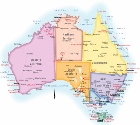
Australia consists of six states, two major mainland territories, and other minor territories. The states are New South Wales, Queensland, South Australia, Tasmania, Victoria and Western Australia. The two major mainland territories are the Northern Territory and the Australian Capital Territory. Western Australia is the largest state covering just under one third of the Australian landmass, followed by Queensland and New South Wales.
Australia also has several minor territories; the federal government administers a separate area within New South Wales, the Jervis Bay Territory, as a naval base and sea port for the national capital. In addition Australia has the following, inhabited, external territories: Norfolk Island, Christmas Island, Cocos (Keeling) Islands, and several largely uninhabited external territories: Ashmore and Cartier Islands, Coral Sea Islands, Heard Island and McDonald Islands and the Australian Antarctic Territory.
The capital city, Canberra, is located in the Australian Capital Territory (ACT). The ACT was created in 1909, and the city of Canberra was designed by an American landscape architect in 1912. The Commonwealth Parliament relocated there from Melbourne in 1927. Canberra has a population of over 300,000 and is the largest inland city.
TASKS
I. Read the text. Find the words that match the definitions below:
1) the real or imaginary line that marks the edge of a state, country etc, or the edge of an area of land that belongs to someone;
2) the distance north or south of the equator (=the imaginary line around the middle of the world), measured in degrees;
3) the whole amount;
4) the right to use an official power to make legal decisions, or the area where this right exists;
5) the regular rising and falling of the level of the sea;
6) an area of countryside or land of a particular type, used especially when talking about its appearance;
7) a group of mountains or hills, usually in a line;
8) a large area of flat dry land;
9) to weaken or damage something by taking away parts of it gradually, or to become weaker in this way;
10) the shape of an area of land, including its hills, valleys etc.;
11) a large, flat area of land that is higher than the land around it;
12) (of land or weather) having little rain; very dry;
13) the natural home of a plant or animal;
14) to become very successful or very strong and healthy;
15) someone whose job is to design buildings.
Date: 2016-03-03; view: 1896
| <== previous page | | | next page ==> |
| Write down your own sentences with these words. | | | Write down your own sentences with these words. |