CATEGORIES:
BiologyChemistryConstructionCultureEcologyEconomyElectronicsFinanceGeographyHistoryInformaticsLawMathematicsMechanicsMedicineOtherPedagogyPhilosophyPhysicsPolicyPsychologySociologySportTourism
MODULE 2. MODERN REALIA OF THE UNITED STATES OF AMERICA (USA)
Exercise 1. Fill in the gaps in the following text with proper names.
The archipelago off the West coast of Northern Europe, comprising more than 5,500 islands is called ________. _________ is the largest island of this archipelago, the second largest is called _________. the country which occupies the largest part of these islands is called the UK, which stands for ___________ . Thus the UK consists of four distinct political divisions - ________, ________ , ________ and _______. Unofficially the country is also known as __________.
Exercise 2. Answer the following questions about the state symbols of the UK:
1. What is the flag of the UK usually called?
2. What does the flag consist of?
3. Why is the flag of Wales not represented in the state flag?
4. What is depicted on the shield of the coat of arms?
5. Who are the supporters of the shield? What do they symbolise?
6. What are the mottoes inscribed on the coat of arms? What is their history?
7. How is the Scottish variant of the coat of arms different from the main one?
8. What is the anthem of the UK called?
Exercise 3. Match the parts of the country with their capitals:
| 1. Scotland | a. London |
| 2. Wales | b. Belfast |
| 3. England | c. Edinburgh |
| 4. Northern Ireland | d. Cardiff |
Exercise 4. Which parts of the UK do these plants symbolise?
 A A
|  B B
|  C C
|  D D
|
Exercise 5. Match the part of the country with its patron saint and its national day:
| England | St Patrick | 23rd April |
| Wales | St George | 30th November |
| Scotland | St Andrew | 17th March |
| Northern Ireland | St David | 1st March |
Exercise 6. Show on the map:
1.The Atlantic Ocean; the North Sea; the Irish Sea; the English Channel; the Straights of Dover; St George's Channel; the North Channel;
2.Rivers in England;
3.Rivers in Scotland;
4.Rivers in Wales;
5.Rivers in Northern Ireland.
Exercise 7. Fill in the table:
| England | Scotland | Wales | Northern Ireland | |
| The longest river | ||||
| The largest lake | ||||
| The highest mountain |
Exercise 8. Show on the map:
1. The mountain ranges in England, Scotland, Wales and Northern Ireland;
2. The biggest cities in all the four parts of the country;
3. The islands belonging to the UK.
Exercise. 9. Fill in the missing information about climate in the UK:
The current climate of the United Kingdom is classified as ______. One of the principle factors which influence the climate is the warming of the waters around the British Isles by the ______.The average annual amount of sunshine for the United Kingdom is relatively low and around 50% of days are ______.
Average annual rainfall exceeds 3 000 mm. The mountains of Wales, Scotland, the Pennines and the Lake District are particularly _____, with rainfall reaching 3 000 mm a year. In contrast, the south, south east, east and the southern midlands receive less than 600 mm of _____ per year. The wettest seasons are ______ and _______.
Generally the UK has mild to cool _____ and warm to hot _____ with moderate variation in temperature throughout the year. In England the average annual temperature is about 10 °C, but over the higher ground this can be several degrees lower. _______ and _______ are often the coldest months, with mean winter temperature of 0°C and the recorded minimum _______ °C. ______ tends to be the warmest month and the highest temperature recorded was ______ °C. However, the average for this month is 15-20 °C.
Exercise 10. Answer the following questions:
1. What mineral resources does the UK have?
2. What is the population of the UK?
3. What are the major national groups leaving in the country?
4. What languages are spoken in the UK? Is there a state language?
5. What is the population of London?
Exercise 11. Characterize the branches of the country’s economy:
1. agriculture
2. fishing
3. manufacturing
4. services
5. creative industries
6. transport
Exercise 12. What do you know about these places in London?
Buckingham palace; Hyde Park; Houses of Parliament; Trafalgar Square; Tower of London; the City; Oxford Street; Fleet Street; the West End; the East End; Kensington Gardens; Piccadilly Circus; the British Museum; St Paul's Cathedral; the Globe Theatre; Wimbledon; Tower Bridge.
What other places of interest in London do you know?
Exercise 13. Revision. What do the following words, phrases and figures refer to?
| Heathrow | EROS | Union Jack | Eire | The Square Mile |
| Cymru | Channel Tunnel | 388 km2 | 23rd April | Great Britain |
| Severn | 346 km | Slieve Donard | Sir Christopher Wren | St Andrews |
| 1 344 m | Loch Lomond | 38,5 °C | rose | harp |
| Hebrides | sheep | Speaker’s Corner | 354 km | the Isle of Man |
| about 59 million | Dieu et mot droit | Big Ben | Glasgow | William the Conqueror |
Further reading
1. Focus on Britain. – London: Foreign and Commonwealth Office, 1993. – 40 p.
2. Sheerin S. Spotlight on Britain [2-d edition] / S. Sheerin, J. Seath, G. White. – Oxford: Oxford University Press, 1990. – 140 p.
3. Vaughan-Rees M. In Britain /M. Vaughan-Rees, P. Byström, S. Bateman. – М.: Титул, 1997. – 122 р.
* It is important to remember that Southern Ireland – that is the Republic of Ireland (also called Eire) – is completely independent.
** The Isle of Wight, the Orkneys, Hebrides and Shetlands are part of the United Kingdom, although the Isle of Man is not.
*** The flag is normally called the Union Jack because it represents a union of countries – England, Scotland, Wales and Northern Ireland.
* Wales was united with England in 1536.
* The Wars of the Roses were a series of civil wars fought in medieval England from 1455 to 1485 between the House of Lancaster and the House of York. The name Wars of the Roses is based on the badges used by the two sides, the red rose for the Lancastrians and the white rose for the Yorkists.
** The battle of Crecy (1346) was fought during the Hundred Years War between the English and the French. The English won a decisive victory in this battle thanks to the value of Welsh longbows used.
* For centuries people from overseas have settled in Britain, either to escape political or religious persecution or in search of better economic opportunities. Jewish refugees who came to Britain towards the end of the 19th century and in the 1930s were followed by other European refuges after 1945. Substantial immigration from the former colonies in the Caribbean and South Asian sub-continent dated principally from the 1950s and 1960s. There are also sizable groups from the United States and Canada, as well as Australians, Chinese, Greek and Turkish Cypriots, Italians and Spaniards.
MODULE 2. MODERN REALIA OF THE UNITED STATES OF AMERICA (USA)
GEOGRAPHY OF THE USA
The term “United States”, when used in the geographical sense, means the 48 states of continental United States, Alaska, Hawaii, Puerto Rico, Guam, and the Virgin Islands of the United States. Forty-eight of the States are in the single region between Canada and Mexico; this group is referred to, with varying precision and formality, as the continental or contiguous United States, and as the Lower 48. Alaska, which is not included in the term contiguous United States, is at the northwestern end of North America, separated from the Lower 48 by Canada. The State of Hawaii is an archipelago in the Pacific Ocean.
1. Geographical position of the USA
The United States of America is a country in the Western Hemisphere. The United States shares land borders with Canada (to the north) and Mexico (to the south), and a territorial water border with Russia in the northwest. The contiguous forty-eight states are otherwise bounded by the Pacific Ocean on the west, the Atlantic Ocean on the east, and the Gulf of Mexico to the southeast. Alaska borders the Pacific Ocean to the south, the Bering Strait to the west, and the Arctic Ocean to the north, while Hawaii lies far to the southwest of the mainland in the Pacific Ocean. The capital city, Washington, District of Columbia, is a federal district located on land donated by the state of Maryland. (Virginia had also donated land, but it was returned in 1847).
Total U.S. area is 9,631,418 km², of which land is 9,161,923 km² and water is 469,495 km². Ranked by land area, the top countries in order are Russia, China, the U.S., and Canada.
2. State symbols of the USA
2.1. The flag of the USA
 The flag of the US (also known as Old Glory, Stars and Stripes or Star-Spangled Banner) consists of 13 horizontal stripes, 7 red alternating with 6 white. The stripes represent the original 13 colonies, the stars represent the 50 states of the Union. The colors of the flag are symbolic as well: Red symbolizes Hardiness and Valor, White symbolizes Purity and Innocence and Blue represents Vigilance, Perseverance and Justice.
2.2. The US Great Seal
The image from the obverse (front) of the Great Seal is often used informally as national arms of the USA. It is only attached (affixed) to certain documents, such as foreign treaties and presidential proclamations. Both sides of the Great Seal can be seen on the back of a U.S. one-dollar bill.
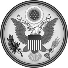 The main figure on the obverse of the seal is a bald eagle with its wings outstretched (or “displayed”, in heraldic terms). From the eagle’s perspective, it holds a bundle of 13 arrows in its left talon, (referring to the 13 original states), and an olive branch, in its right talon, together symbolizing that the United States of America has “a strong desire for peace, but will always be ready for war”. Although not specified by law, the olive branch is usually depicted with 13 leaves and 13 olives, again representing the 13 original states. The eagle has its head turned towards the olive branch, said to symbolize a preference for peace. In its beak, the eagle clutches the motto E pluribus unum (“Out of Many, One”). Over its head there appears a “glory” with 13 mullets (stars) on a blue field. In the current (and several previous) dies of the great seal, the 13 stars above the eagle are arranged in rows of 1-4-3-4-1, forming a six-pointed star.
The shield the eagle bears on its breast, though sometimes drawn incorrectly, has two main differences from the American flag. First, it has no stars on the blue chief (though other arms based on it do: the chief of the arms of the United States Senate may show 13 or 50 , and the shield of the 9/11 Commission has, sometimes, 50 mullets on the chief). Second, unlike the American flag, the outermost stripes are white, not red; so as not to violate the heraldic rule of tincture.
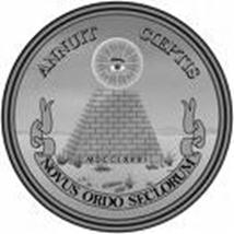 The 1782 resolution adopting the seal blazons the image on the reverse as “A pyramid unfinished. In the zenith an eye in a triangle, surrounded by a glory, proper”. The pyramid is conventionally shown as consisting of 13 layers of blocks to refer to the 13 original states. There are also 13 sides shown on the ribbon. The adopting resolution provides that it is inscribed on its base with the date MDCCLXXVI (1776) in Roman numerals. Where the top of the pyramid should be, the Eye of Providence watches over it. Two mottos appear: Annuit Cœptis signifies that Providence has "approved of (our) undertakings”. Novus Ordo Seclorum, freely taken from Virgil, means “a new order of the ages”.
Date: 2015-01-02; view: 3392
| <== previous page | | | next page ==> |
| Comprehension | | | The USA physical geography |