CATEGORIES:
BiologyChemistryConstructionCultureEcologyEconomyElectronicsFinanceGeographyHistoryInformaticsLawMathematicsMechanicsMedicineOtherPedagogyPhilosophyPhysicsPolicyPsychologySociologySportTourism
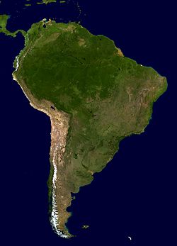
CENTRAL AND SOUTH AMERICA
| CENTRAL AMERICA is a narrow bridge of land linking Mexico in the north to South America in the south. A string of mountains runs down its length, capped by volcanoes. The beautiful, palm-fringed islands of the Caribbean Sea lie off its east coast. South America, the fourth largest continent, contains a range of very different landscapes. About 60 percent of the continent is covered in vast, grassy plains. |
| ||||||||||
| The towering Andes Mountains stretch along the west coast, with the long, thin Atacama Desert sandwiched between the mountains and the sea. Tropical rain forests spread in a lush green blanket across huge areas of the northeast. | |||||||||||
|
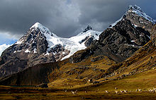
| THE ANDES Stretching for 4,505 miles (7,250 km) along the entire length of South America, the Andes are the world’s longest mountain range. Many peaks rise above 19,685 ft (6,000 m). The mountains were formed when two plates of the Earth’s crust collided. The plates are still moving, causing numerous earthquakes and volcanoes along the range. An extinct volcano, Aconcagua, is the highest Andean peak and the highest mountain in South America at 22,835 ft (6,960 m). | |||||||||

| |||||||||||
| The world’s highest navigable lake, Titicaca, lies in the Andes between Peru and Bolivia. | 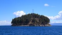
| ||||||||||
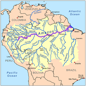
| THE AMAZON RIVER The world’s largest rainforest grows in the vast basin of the mighty Amazon, the longest river in South America. The Amazon rises high in the snowcapped Andes in Peru, then flows 4,001 miles (6,439 km) across Peru and Brazil to its mouth in the Atlantic Ocean. The Amazon carries more water than any other river. | ||||||||||
| At its mouth the Amazon is so wide that you cannot see from one bank to the other. The river discharges so much water into the ocean that the water is still brackish 112 miles (180 km) out to sea. | | ||||||||||
| | 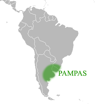 Rolling grasslands cover the center of Argentina and extend into neighboring Paraguay. These are the pampas, vast open plains that stretch across an area of 250,967 sq miles (650,000 sq km). The western pampas are dry, semidesert, but the eastern part has frequent rainfall. The pampas form the economic heartland of Argentina.
| ||||||||||
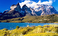
| PATAGONIA In the far southeast of South America lies a huge, dry, windswept plateau of land called Patagonia. This region is sparsely populated, but some small groups of sheep farmers live near Colorado and Negro rivers. They include a community of Welshspeakers whose ancestors settled in the region during the 1860s. Northern Patagonia is semidesert with some scrubby vegetation. The south is colder, drier, and bleaker, with very little plant life. | 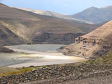
| ||||||||||
| |||||||||||
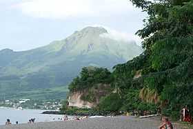
| MONT PELÉE On May 8, 1902, Mont Pelée, a volcano on the Caribbean island of Martinique, erupted. A stream of lava, gas, and hot dust poured down the mountain toward the port of St. Pierre, engulfing the town and killing 30,000 people. Volcanoes are a constant hazard in the Caribbean – two-thirds of Montserrat, including the capital Plymouth, became uninhabitable when the Soufrière Hills volcano erupted in 1995. | ||||||||||
| ISTHMUS OF PANAMA The Isthmus of Panama is a narrow strip of land that separates the Caribbean Sea in the Atlantic Ocean from the Gulf of Panama in the Pacific. It forms the land bridge linking Central America to South America. The Isthmus is only 30–130 miles (48–210 km) wide. Its narrow shape and strategic location made it the ideal choice as the site for the Panama Canal. | 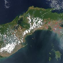
| ||||||||||
EUROPE
| A great curve of mountain ranges that includes the Pyrenees and the Alps roughly divides the cooler north of Europe from the warmer south. In the far north, treeless tundra merges into cool coniferous forests that extend across Scandinavia and into Russia. | |||||||||
| South of this lies the fertile North European Plain, which supports most of the continent’s agriculture and mixed woodland. | 
| |||||||||
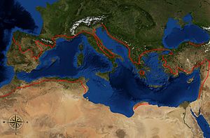
| By contrast, the Mediterranean region to the south is hot and almost desertlike in places. | |||||||||
| Volcanic activity is confined to Iceland and southern Italy, where Mount Etna is constantly active. The Ural and Caucasus mountains form Europe’s eastern borders. | 
| |||||||||
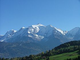
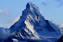
| THE ALPS The mountains that form the Alps run from southeastern France, through Switzerland and Italy, into Austria. In the last 2 million years, ice has molded the scenery, carving pyramid-shaped peaks, like the Matterhorn, knife-edged ridges, dramatic waterfalls, and armchairshaped basins filled with lakes. Alpine plants, such as the Bird’s Eye primrose, have adapted to growing at high altitudes. | |||||||||
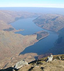
| THE LAKE DISTRICT The 15 lakes of the Lake District in northwestern England lie in U-shaped valleys extending outward like the spokes of a wheel from an uplifted dome of low mountains. Long ago, the valleys contained rivers, but during the Ice Age these were deepened by the movement of glaciers. Most were dammed by eroded rock left behind when the glaciers melted. The erosion of the main valleys has cut off tributary valleys and left them “hanging” above the main valleys, often with waterfalls cascading from them. |
| |||||||||
| 
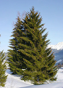
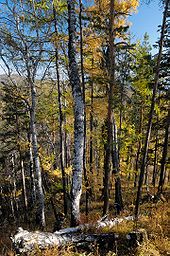
| NORTHERN FORESTS A thick band of dense coniferous forest, known as taiga, covers northern Europe. Conifers (trees that have cones), such as spruce and pine, keep their leaves all year round and can withstand heavy snow. They also provide winter food and shelter for many animals. | ||||||||
| NORTHERN PLAINS The North European Plain stretches from southern England across France and Germany as far as Russia, ending at the Ural Mountains. Most of the plain is low-lying, and in the Netherlands it even lies partly below sea level. Some of the world’s most fertile farmland is found here, as well as important deposits of coal, oil, and natural gas. This is Europe’s most densely populated area and contains many major cities. | 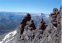
| |||||||||
| ||||||||||

| THE MEDITERRANEAN The region around the Mediterranean Sea has a distinctive climate of hot, dry summers and mild, rainy winters. These conditions are perfect for growing crops such as citrus fruits, grapes, and olives. Many trees, such as cork oaks, develop thick bark as a protection against the heat. | |||||||||
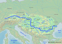
| THE DANUBE The Danube, western Europe’s longest river, flows eastward from its source in Germany to its mouth on the Black Sea. |
| |||||||||
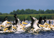
| It serves as a trade route between the nine countries that lie along its course. The Danube delta, where the river divides into numerous channels, is an important wetland area. About 300 different bird species have been recorded in the delta, as well as boars, deer, and wild cats. | |||||||||
ASIA
| Stretching from the frozen Arctic to the hot Equator, Asia is by far the world’s largest and most mountainous continent. Much of the land is barren, with vast, empty deserts in southwest and central Asia, and the remote, windswept plateau of Tibet to the north of the Himalayan mountains. Asia also has some of the world’s most fertile plains and valleys beside rivers that include the Mekong, Indus, and Euphrates. In Southeast Asia, the land is mainly mountainous or covered in tropical rain forests that are teeming with wildlife. Away from the mainland, scattered on either side of the Equator, lie thousands of islands, many of them volcanic. | 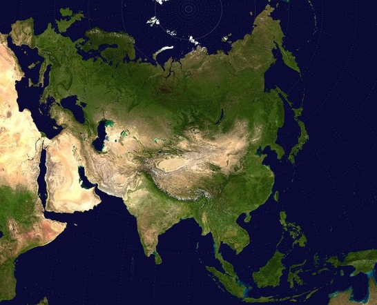
| |||||||
| 
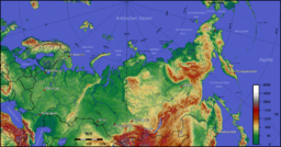
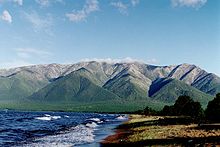
| Most of Siberia, the Asian part of Russia, is bitterly cold in winter. In the north lies the tundra, where part of the soil has been frozen since the end of the last Ice Age. Beneath its surface there are vast supplies of minerals. To the south lies the world’s largest coniferous forest. This cold forest makes way for a dry grassland area, known as steppe, which forms Russia’s main farming region. | ||||||

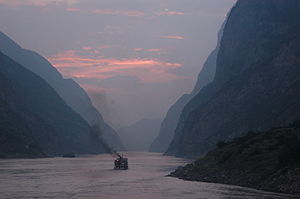
| THE YANGTZE RIVER From its source in the Tanggula Mountains on the plateau of Tibet, the Yangtze River flows through mountainous land for most of its course. On its final stages, it follows the southern edge of the Great Plain of China until it reaches the East China Sea. In the flatter areas, the Yangtze supplies water for irrigation. In the past, flooding has caused thousands of deaths. | |||||||
| ||||||||
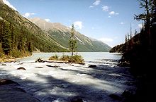
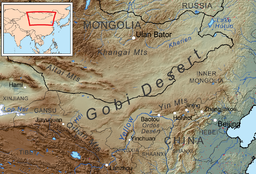
| CENTRAL DESERTS Unlike most deserts, the Takla Makan and Gobi in central Asia have hot summers, but extremely cold winters. Much of their landscape is made up of bare rock, with huge expanses of shifting sand. Vegetation is sparse, except in river valleys, as shown here in the Takla Makan. Some animals, including wild camels, can survive cold winters in the Gobi. |

| |||||||
| ||||||||
| 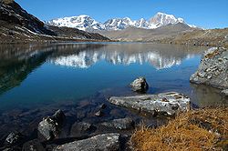
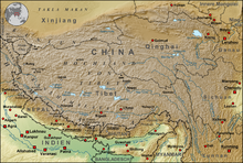
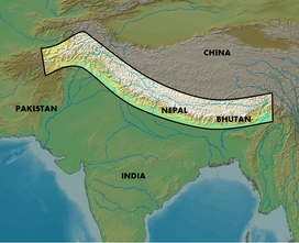
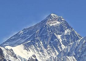
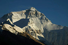
| THE HIMALAYAS The Himalayas form a massive land barrier between the Indian Subcontinent and Tibet. | ||||||

| ||||||||
| The range is permanently snowcapped and contains the world’s highest peak, Mount Everest. The mountains began to form about 50 million years ago when a moving plate, carrying the Subcontinent, began to push against the Eurasian plate. When the plates collided, the edge of the Indian plate was forced under the Eurasian plate, and the seabed in between was folded up to form the Himalayas. |
|
| ||||||
| | ||||||||
| 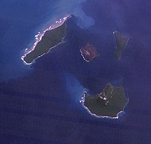
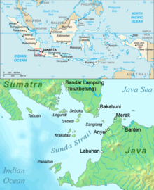
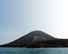
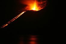
| THE RING OF FIRE Volcanoes erupt so often on the rim of land and islands around the Pacific that the region is called the “Ring of Fire.” The most famous eruption took place in 1883, when the volcanic island of Krakatoa, west of Java, erupted. The explosion was so loud it was heard in Australia. In 1928, a new volcano burst into life on the island. It was named Anak Krakatoa, meaning “son of Krakatoa.” | ||||||
|
| |||||||
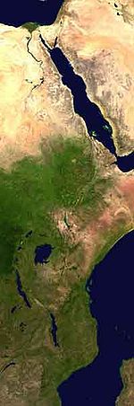
3.14. AFRICA
| The second largest continent, Africa is a land of contrasts. To the north lies the great Sahara, the largest desert in the world, yet the central equatorial area is covered by dense tropical rain forests, while farther south a series of grassy plateaus (areas of flat highland) give way to narrow coastal plains. Major mountain ranges include the Atlas in the north and the Ruwenzori range on the Uganda-Democratic Republic of Congo border. | 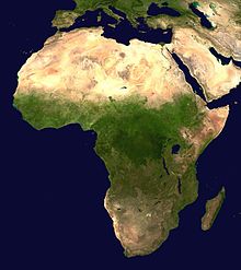
| |||||||||||||||
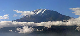
| Africa’s highest mountain is Kilimanjaro, a dormant volcano, in Tanzania. To the east is the Great Rift Valley, which contains several huge lakes. Some of the world’s longest rivers drain the continent, including the Nile, Niger, Congo, and Zambezi. | |||||||||||||||
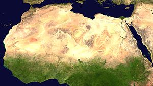
| DESERTS Africa has three huge deserts. The vast Sahara is the world’s largest desert and dominates the northern third of the continent. Thousands of years ago the Sahara had a moist | |||||||||||||||
| climate. Today, the path of wet winds blowing in from the sea is blocked by other winds blowing outward from the desert. | |||||||||||||||
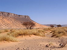
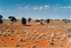
| The Namib and Kalahari deserts cover vast areas of southwestern Africa. Although it lies along the coast, the Namib Desert (shown here) is particularly barren and dry. | 
| 
| ||||||||||||||
| GREAT RIFT VALLEY The Great Rift Valley stretches from Mozambique in the south, through eastern Africa and the Red Sea, into Syria. In most places the valley is 19–62 miles (30–100 km) wide, with steep sides rising up to 6,562 ft (2,000 m). The valley was formed as blocks of land sank between faults in the Earth’s crust. In eastern Africa, the valley has two main branches. The Rift Valley is marked by volcanoes, hot springs, and a long chain of lakes. | |||||||||||||||
| RAIN FORESTS The world’s second largest rain forest, after the Amazon, lies in central Africa. The Congo teems with plant and animal life, including rare creatures such as okapis. It was also the home of groups of pygmies, but many now live in settled villages, because | | |||||||||||||||
| vast areas of forest have been destroyed for logging and farming. One group, the Bambuti, still live in the northeastern forests of Democratic Republic of Congo. | ||||||||||||||||
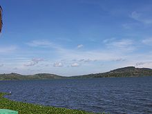
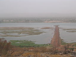
| LAKE VICTORIA Lake Victoria is Africa’s largest lake and the second largest freshwater lake in the world. Lying on the Equator, between Kenya, Tanzania, and Uganda, it covers about 26,828 sq miles (69,484 sq km) and reaches 269 ft (82 m) at its deepest point. The Nile River flows out of the northern end of the lake. Lake Victoria is rich in fish, which provide an important source of income for the large numbers of people living along the lake shores. | 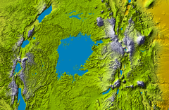
| 
| ||||||||||||||
| | ||||||||||||||||
|
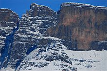
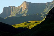
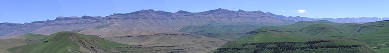
| THE DRAKENSBERG MOUNTAINS The highest mountains in southern Africa are the Drakensberg. They form part of the rim of a saucer-shaped plateau of high land called the Great Escarpment. In the local Zulu language, the mountains are known as Quathlamba, which means the “barrier of pointed spears.” The highest peak, Thabana Ntlenyana, rises 11,424 ft (3,482 m) above sea level and is capped with snow in winter. | ||||||||||||||
| ||||||||||||||||
| THE NIGER RIVER The Niger is Africa’s third longest river. From its source in Guinea, it flows some 2,597 miles (4,180 km) across western Africa to its delta in Nigeria. Along its course, the Niger drains a river basin almost three times the size of France. | 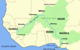
| |||||||||||||||
| The Niger’s water is used for irrigation and hydroelectric power, but its usefulness for transportation is limited by its many waterfalls and rapids. | |||||||||||||||
| 
| 
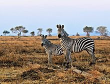
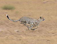
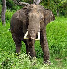
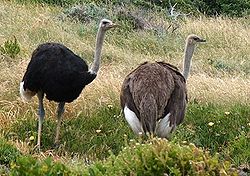
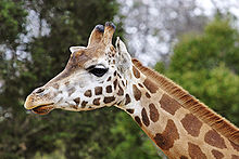
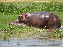
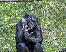
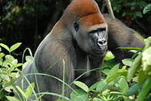
| WILDLIFE Africa has an amazing variety of wildlife. Huge herds of zebras and wildebeests roam the plains, preyed on by lions and cheetahs. There are elephants, ostriches, and long-necked giraffes. Hippos wallow in rivers and swamps. In the rain forests live chimpanzees and gorillas, among the rarest animals on Earth. | |||||||||||||
| 
| 
| ||||||||||||||
| 
| 
| ||||||||||||||
| ||||||||||||||||
Date: 2015-04-20; view: 4000
| <== previous page | | | next page ==> |
| Parts of the world | | | AUSTRALASIA AND OCEANIA |