CATEGORIES:
BiologyChemistryConstructionCultureEcologyEconomyElectronicsFinanceGeographyHistoryInformaticsLawMathematicsMechanicsMedicineOtherPedagogyPhilosophyPhysicsPolicyPsychologySociologySportTourism
Oceanographic regime 6 page
Propagating across the Voronka, Gorlo, and Bassein to the White Sea bays, this long wave becomes steeper. Thus, at the Sosnovets station the wave period was 68 hr and its amplitude reached 69 cm. At the Archangelsk and Kem-Port stations, these characteristics were 65hr and 100 cm, and 62 hr and 92 cm, respectively. Inzhebeykin (2001), making use of a hydrodynamic model, revealed the existence of a deforma- tion of a three-day surge wave in the course of its propagation over the White Sea. About 35% of the total deformation occurred on the way to the Gorlo, another 55% occurred within the Gorlo proper. In the Bassein, the distorted wave continues to
|

Figure 4.34. Types of cyclonic movements from 1902-1965. The moving cyclones fall into the following types: (a) diving , (b) western above the Barents Sea, (c) western above the White Sea, (d) southern, and (e) abnormally displacing.
 |
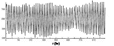
 Figure 4.35. Storm-driven surges at the Sosnovetcs (1), Mudyug (2), Archangelsk, (3), and
Kem-Port (4) stations during the period 31 October-5 November, 1963.
propagate but without any significant changes, and subsequent deformations only occur in the Kandalakshskiy, Onezhskiy, and Dvinskiy Bays.
One of the most substantial surges in the White Sea was observed on 22-23 October, 1965. It was also caused by a diving cyclone. At the Mudyug station, the maximum surge was at least 50% due to the surge wave moving from the Barents Sea and only 35% due to local winds (Figure 4.35).
|
Western Barents Sea cyclones produce storm-driven surges in the White Sea that develop similarly to surges generated by the diving cyclones. Therefore, most significant surges in the White Sea are formed according to the following scheme. Western cyclones, whose center s trajectories run over the Barents Sea, as well as
diving cyclones, generate a long wave in the Barents Sea, whose propagation speed exceeds by far the velocity of baric depression propagation. It happens because, given the depths in the western part of the Barents Sea, the long wave has a velocity of about 150 km hr-1, whereas the speed of the cyclone movement over the Barents Sea is, on average, 34 km hr-1. This free surge wave propagates further on as a Kelvin wave from the Barents Sea to the White Sea with a velocity of about 40 km hr-1, being subjected to considerable deformations owing to its interactions with the tide, as well as the impact of bottom relief and coastal geometry. By the time the crest of the surge wave reaches the apex of the bays (including Mezenskiy Bay), the low-pressure center has had enough time to move further east and south-eastward, to a zone located to the east off the Barents and White Seas and limited approximately by the meridians 45oE and 65oE.
Thus, by the moment of onset of maximal water levels, the White Sea appears to be in the rear part of the cyclone, within the zone of the extreme winds of north- westerly directions. In the southern regions of the sea, these winds cause some elevation of their level, which, being superposed upon the induced Barents Sea surge, results in maximal total and non-periodic water levels in Onezhskiy, Dvinskiy, and (sometimes) Mezenskiy Bays. The induced surge wave contributes most significantly to the formation of maximal water levels. In the northern and north-western sea regions, because of the different directions of the impacts of the induced surge and local winds, the resultant surge is much smaller than it is in the southern areas. The influence of gradients of atmospheric pressure at the sea surface for the cyclone types in question is insignificant. The interaction between the tide and the surge can appreciably increase (up to 25%) the sea level in Mezenskiy, Onezhskiy, and Dvinskiy Bays. It should be noted that, unlike the diving cyclones, the western ones, whose centers move over the Barents Sea, form a more pronounced pre-surge lowering of the sea level, which is most often caused by winds resulting in a negative surge.
When the centre of a cyclone, moving from eastward or north-eastward, passes over the White Sea, the role of the wind constituent in water level elevations increases. When a cyclone moves from the west, the wind causes a negative surge first, and later, when the cyclone moves eastward or north-eastward, a positive surge originates in the southern sea regions. In northern regions, the sequence of water level variations is contrary: a positive surge is followed by a
negative surge. There, a certain delay in the response of the water level to the action of wind is observed.
An example of a storm-driven surge, caused by a western cyclone, whose center moved over the White Sea, is the surge wave of 11-12 December, 1957. A deep cyclone with the sea level pressure (SLP) in its center as low as 963 HPa at 0300,
10 December, 1957 was located in the vicinity of the city of Leningrad (St. Petersburg). It covered the major part of European Russia. The cyclone had great
temperature contrasts (of the order of 10oC) and moved north-eastwards with a velocity of 25-30 km h-1. The cyclone trough became deeper and extended to the north-east. By 2100 on 10 December, near its occlusion point, a partial cyclone was formed in the region of Onezhskiy Bay. The basic cyclone was filled up by about 0300 on 11 December, and the partial one, having become a basic cyclone, began moving north-eastward. By 1500 on 11 December, the White Sea was in the rear of this system, where western winds with speeds of 15-20 m s-1 (and in some places up to 25m s-1) caused a surge wave in the southern part of the White Sea. As is normal for this type of cyclone, sea level elevations in Onegzhskiy Bay were observed earlier than in Dvinskiy Bay. For instance, if the peak of the surge wave at the Onega station was observed at 0100 on 12 December, then in the vicinity of Archangelsk (Solombala station) it occurred the same day at 1000. The cyclone s center at the moment of the maximum surge at the Archangelsk station was northwards off the city of Naryan-Mar.
The role of the interactions between the tide and the surge when sea level elevations are driven by this type of cyclone is far less important than during surge events owing to diving and western cyclones passing over the Barents Sea. The role of the atmospheric pressure gradient in the formation of the surge component of the sea level elevation rises to 20-25% in the rear parts of Dvinskiy and Onezhskiy Bays, and up to 30-35% at the Kem-Port, Solovki, and Sosnovets
stations.
The number of surge events due to southern cyclones is much lower than that caused by western or diving cyclones. Cyclones of the southern type usually come from the central European Russian regions. There they deepen and move north- wards to eventually pass over the White Sea, and further to eastern or south-eastern parts of European Russia. The White Sea (which appears to be at the western or north-western cyclone peripheries) is then subjected to the impact of northerly and north-westerly wind. Such winds cause mild positive surges in the southern regions of the White Sea and insignificant negative surges in its northern areas. With such cyclones, it is the wind that mainly contributes to sea level variations. The role of the atmospheric pressure gradient is negligible and accounts for about 10% in the surge constituent of the sea level. The impact of interactions between the tide and the surge is insignificant. At the moment of maximal surge at the Mudyug station, the cyclone gradually fills up, its center being located west of the White Sea within the 60-62oN and 45-55oE zone (Figure 4.35).
The trajectories of anomalously moving cyclones are quite diverse (Figure 4.34(e)). The prevailing contribution of winds to the surge generated by such cyclones is a feature in common. In anomalously moving cyclones, the winds of northern bearings cause a surge in the southern regions of the sea, yet never reaching maximum magnitudes, and a negative surge in its northern regions. The contribution of atmospheric pressure gradients is rather variable, but most frequently it is rather insignificant. The contribution of non-linear interaction between the tide and the surge varies substantially. However, on the whole, it is lower compared to the cases of surges induced by diving and/or western cyclones moving over the Barents Sea.
|
Negative surges in the White Sea are mostly formed under the influence of anticyclones moving over the White and Barents Seas. Inzhebeykin (1987) shows that the White and Barents Sea negative surges occur when atmospheric antic- yclones arrive in a region, which can be described as an imaginary circle with its center in the vicinity of the city of Apatity and adjacent to parallels 60oN in the south and 78oN in the north. Most frequent (up to 78%) are the arrivals of atmospheric high-pressure areas in the region of the imaginary circle from the north-west and north. Typical anticyclone parameters causing negative surges are characterized by the atmospheric pressure of 1,030 HPa in the center, wind speeds of about 21 km hr-1, and length of 1,600-1,800 km. A typical situation resulting in a positive surge occurs when a medium-size anticyclone enters the Barents Sea area from the north-west or north.
As to the absolute measures, the negative surges are lower but longer than the positive ones. These specific features of negative-positive surge variations are deter- mined by the respective conditions of formation of these phenomena. The reason why positive surges are generally higher than negative ones (Table 4.5) resides in the fact that the wind effect is enhanced in cyclones due to the atmospheric pressure drop, whereas with negative surges a sharp decrease in the atmospheric pressure is compensated for by the wind effect. A shorter lifetime of positive surges in compar- ison with negative ones is due to a longer lifetime of higher pressure areas over the above-mentioned regions in comparison with the time of cyclone passage over the area.
Occasionally, insignificant negative surges (mostly in northern sea regions) appear due to local winds during the passage of baric depressions. A considerable influence of local winds upon negative surges is further evidenced by the fact that negative surges are often observed when cyclones and anticyclones move, respec- tively, westward and eastward off the White Sea, as well as when southerly winds become prevalent over the White Sea. The effective wind direction for negative surges constitutes 135o, 240o, and 155o at the Onega, Kem-Port, Archangelsk, and Mudyug stations, respectively.
Table 4.5. Mean and maximal heights (h) and periods (T ) of negative surges (numerator) and positive surges (denominator) in various regions of the White Sea.
From Potanin (1971).
| Station | Mean value of h (cm) | Mean values of T (hr) | Maximal value of h (cm) | Maximal value of T (hr) |
| Sosnovets | 32/52 | 119/89 | 80/139 | 299/206 |
| Kandalakshskiy | 27/46 | 109/79 | 72/107 | 252/196 |
| Bay | ||||
| Kem Port | 35/61 | 115/83 | 92/157 | 277/176 |
| Onegskiy Bay | 43/88 | 99/79 | 118/214 | 236/181 |
| Dvinskiy Bay | 35/76 | 79/89 | 101/196 | 172/183 |
4.7.3 Mesoscale sea level variability
Mesoscale variability comprises tidal and seiche-induced variations, with periods varying from a few hours to dozens of hours. The next two sub-sections describe these two sources of mesoscale sea level variability in the White Sea.
Tidal variations
Tidal motions in the White Sea contribute most significantly to the actual sea level variations. A considerable complexity and diversity in these are typical. They are induced in the White Sea by the Barents Sea tides because the White Sea s proper tide is very low, and its contribution to sea level variations does not exceed 3 cm (Kravets, 1982).
To achieve a more detailed description of the properties and specific features of the observed tides, the latter are usually presented as a sum of simple harmonic constituents with periods corresponding to those of the components of harmonic decomposition of the potential of the tide-forming force. Tides within the White Sea have a distinctly pronounced semi-diurnal pattern, with a predominance of waves of the corresponding period: M2, S2, N2, and K2. It is only in the region of Zimniaya Zolotitsa and Veprevsky Cape, where the node of waves M2 and S2 is located, that the tides become mixed, with a prevalence of the semi-diurnal type (the relation of the sums of amplitudes of the basic diurnal waves K1 and O1 to the sum of the amplitudes of the major semi-diurnal waves M2 and S2 is equal to 0.63 (Kravets, 1982)). Due to the highly complicated morphometric conditions in the sea and the deformation of the tidal wave in shallow waters, semi-diurnal tides become asym- metric: the period of level decrease differs markedly from the period of level growth. In this respect, most characteristic are tidal level variations in the Kandalakshskiy Bay, where the period of growth is less than that of decrease, and in the Dvinskiy Bay, where, on the contrary, the period of decrease is less than that of growth. Besides, in the semi-diurnal cycle of sea level variation, in the Kandalakshskiy Bay a short time interruption of the level decrease is observed, and in the Dvinskiy Bay there is an interruption in the sea level growth (sometimes the growth is even replaced by a decrease, a phenomenon which bears the name of a dead tide). Such distortions of the tide-driven level variation are due to non-linear effects and are described by the corresponding shallow-water harmonics (Figure 4.36).
There are two types of non-linear shallow-water harmonics: deformed ones, caused by an individual distortion of every major/basic constituent of the tide; and combined harmonics, caused by the interaction between the basic constituents. Both types of non-linear effects take place in the White Sea. Among the shallow-water harmonics, predominant are quarter diurnal M4 and MS4, and a 1/6-day wave M6; the harmonics M4 and M6 are generated as a result of non-linear deformation of wave M2, and MS4 is formed due to a non-linear interaction of the constituents M2 and S2 (Hydrometeorology and .. ., 1993).
Tides sometimes become deformed so heavily that double semi-diurnal tides
come to life (i.e., high and low water can be observed four times during 24 hours). This phenomenon was observed, for example, in the vicinity of the Veprevsky Cape. It is known that co-tidal spatial distributions of tidal waves with similar periods
|
 (a)
(a)

 (b)
(b)
 (c)
(c)
 (d)
(d)
 (e)
(e)
Figure 4.36. Variations of sea level (cm) at the following stations: (a) Abramovsky, (b) Zimnegorsy, (c) Kashkarantcy, (d) Mudyug, and (e) Sosnovets.

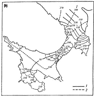
Figure 4.37. Spatial distributions of phases (1) and amplitudes (2) for waves K1(a), M2 (b), and M4 (c).
|
have the same characteristic features. Figure 4.37 shows such maps for waves K1, M2, and M4, as these are the most significant waves in their frequency range. A characteristic feature of diurnal waves is an amphidromic system in the Gorlo with a center in the region of the Intsy Cape (Kravets, 1982). The direction of rotation of lines of equal phases around the amphidromic point is counterclockwise. The greatest wave magnitude K1 (43 cm) is observed at the entrance to the White Sea, in the area of Lumbovskiy Bay. In the rest of the regions of the White Sea, these magnitudes are small, and in the Bassein they do not exceed 14-16 cm, somewhat increasing in the inner parts of the bays. The magnitudes of other diurnal waves (O1, P1, Q1) are several times smaller than the K1 magnitude (Kravets, 1982) (e.g., their amplitudes, greatest in the White Sea, are observed in the Lumbovskiy Bay and constitute 8, 5, and 4 cm, respectively (Hydrometeorology and .. ., 1993)).
Semi-diurnal tides are characterized by the presence of an amphidromic system with a center located on the Veprevsky Cape traverse. The latter is shifted closer to the Zimniy coast (Figure 4.37), and this shift is the largest for the N2 wave and the smallest in the case of the S2 wave. For waves M2 and S2, a degenerate (confluent) amphidromy is also observed near the Letniy coast of the Dvinskiy Bay. The greatest magnitudes (double amplitudes) of semi-diurnal waves occur in the Mezenskiy Bay and constitute, for waves M2, S2, N2, and K2, 6.0, 1.4, 1.0, and 0.2 m, respectively. The distribution of isophases and isoamplitudes of shallow-water waves is of a complex nature. Thus, for the prevailing quarter diurnal harmonic M4, four amphi- dromic systems are established (Figure 4.37) (Kravets, 1982). The amphidromes
located in the Gorlo and Mezenskiy Bay have a common antinode in the Voronka. The system of amphidromes in the Gorlo-Bassein and the Bassein-Onezhskiy Bay areas are linked by common antinodes located in the vicinity of the Intsy Cape and Solovetskiy Archipelago, respectively. The largest amplitudes of the M4 harmonic are observed at the apexes of Mezenskiy (28 cm) and Kandalakshskiy (20 cm) Bays. The amplitude of the 1/6-day wave M6 in the sea does not exceed 5-8 cm, except for the estuaries of the Mezen and Kuloy Rivers, where it reaches 20 cm.
Maximal tidal deviations from the mean sea level are mainly formed by semi- diurnal waves. Therefore, they can be characterized by the amplitude of the syzygial tide. Due to the influence of shallow-water waves, the sea level increases and decreases are not equal. At the southern extremity of the Voronka, the syzygial tide reaches nearly 6 m, and in Mezenskiy Bay it is 8 m.
In the Bassein, the syzygial tide is about 1.5m and increases up to 2.2 m in the Kandalakshskiy Bay and up to 2.9 m in the inner part of the Onezhskiy Bay.
In the Dvinskiy Bay, the tidal amplitude does not exceed 1.5m. The largest magnitudes of the syzygial tide are observed in the Mezenskiy Bay (about 9 m). The smallest magnitudes of the tides of this type are registered at the boundary separating the Gorlo and the Bassein (less than 70 cm; Kandalakshskiy 80 cm) - they are even smaller near the Veprevsky Cape (about 40 cm).
Seiche variations
The intensive tidal motions observed in the White Sea possess a considerable number of overtones, and their frequencies are close to those of seiche oscillations. This makes it rather difficult to identify them in the spectrum of total sea level variations. On the other hand, the sophisticated contours of the coastline and bottom relief make it impossible to employ simple formulae or analytical methods of solving the equations that describe the seiche oscillations. For a long time, the latter remained inadequately studied.
Seiches in the White Sea can be caused by abrupt changes in wind directions and/or atmospheric pressure over the White Sea proper in conditions of fast-moving cyclones and anticyclones. Seiches can also be due to storm-driven surge waves entering the White Sea from the Barents Sea. Specific morphometric features of the White Sea affect the parameters of the inherent seiche oscillations; the latter can have an appreciable amplitude if the period of their proper variations in the White Sea, its individual bays, or their systems coincide with the period of the forcing.
To evaluate the reaction of the White Sea water to the driving forces of a certain frequency, Inzhebeykin (2001) performed a series of simulations by making use of the model reported in his earlier work (Inzhebeykin, 1987). At the boundary (along the Kanin Nos-Sviatoy Nos transect) he assumed the positive surge-driven waves to be Kelvin waves with a period ranging from 3-48 hr. Calculations were performed with a time step of 0.1 hr. In order to evaluate the sea level reaction to forcing oscillations, and determine the resonance frequencies, the total time-averaged energy of the oscillations was assessed. It has been found that the period of oscilla-
|
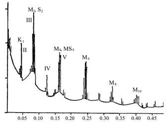
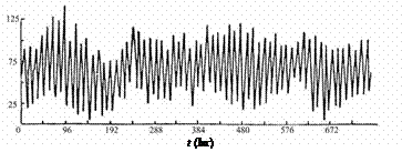
 Figure 4.38. Spectrum of sea level oscillations as registered at the Onega station.
tions for the first mode is 35.7 hr. Oscillation periods corresponding to 2, 3, 4, and 5-node seiches constitute 18.5, 12.5, 7.5, and 6 hr, respectively. The amphidromic point of the first oscillation mode at a resonance frequency corresponding to a 1-node seiche is located in the north-eastern part of the Gorlo south-west of the mid-point of the line connecting the Voronov and Danilov Capes. The amphidromic system forms a cyclonic phase cycle (rotation). The highest values of sea level variations (up to 1.25m) can be formed by a 1-node seiche at the apex of Onezhskiy Bay. In the inner parts of Kandalakshskiy and Dvinskiy Bays, the amplitude can be 1 and 0.75m, respectively.
It should be noted that in the spectrum of sea level oscillation at the Onega station presented in Figure 4.38, for the time period extending from January to April 1966, the peak corresponding to the period of 35.7 hr is not discernible. This may be due to the nature of the synoptic processes that occurred during the above period: as a result, oscillations at this frequency did not originate. Also, the reason might be resulting from the presence of ice cover, which could distort sea level variations.
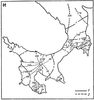
The second mode of resonance oscillations corresponding to a 2-node seiche has a period of 18.5hr. There is one amphidromic point located in the eastern part of the Bassein near the boundary conditionally separating the Gorlo and Bassein (Figure 4.39).
The second amphidromy, which is a degenerate amphidromic system, is located in the north-eastern part of the Voronka, southwards off the Kanin Nos Cape. Both amphidromic systems have a cyclonic nature. The greatest oscillations driven by a 2-node seiche can occur in the Mezenskiy Bay (up to 55 cm), in the Voronka and Onezhskiy Bays (up to 25cm), and in Kandalakshskiy and Dvinskiy Bays (up to 15cm).
The third mode of oscillations at the seiche frequency, with a period of 12.5hr, generates three amphidromic systems with centers located: (a) in the
eastern part of the Voronka; (b) in the extreme south-western part of the Gorlo, close to the Zimnegorskiy Cape; and (c) within a degenerate amphidromic system in the region of the Letniy Orlov Cape in the north-eastern part of Onezhskiy Bay (Figure 4.39).
All three amphidromic systems have a cyclonic nature. At this mode, the maximal seiche variation can be observed in the inner part of Mezenskiy Bay (up to 150 cm). In Kandalakshskiy and Dvinskiy Bays this variation constitutes 30 and 45cm, respectively.
All four amphidromic systems of oscillations have a cyclonic nature at a resonance frequency corresponding to a 4-node seiche with a period of 7.5hr; their centres are located (a) south-westwards off the Kanin Peninsula; (b) at the boundary separating the Voronka and Mezenskiy Bay, along the transect connecting the Konushin Cape and Morzhovets Island; (c) in the central part of the Bassein; and
(d) in the central part of Onezhskiy Bay, but closer to the Liamitskiy coast.
It should be noted that across a relatively small water area constituting the inner part of Mezenskiy Bay, the fourth mode can cause oscillations of more than 160 cm, which is an absolute maximum out of all magnitudes assessed for the oscillations from the first to the fifth mode throughout the White Sea.
At the same time, sea level variations in the case of the fourth mode are not significant in other regions of the White Sea and may only reach 65cm in the Gorlo, 45cm in the inner part of Kandalakshskiy Bay, 25cm in the Voronka and at the apexes of Dvinskiy and Onezhskiy Bays, and 10 cm in the Bassein (Figure 4.39).
The period of oscillations at a resonance frequency corresponding to a 5-node seiche is 6.0 hr. Amphidromes having a cyclonic nature are located (a) in front of the entrance to the Gorlo, on the traverse relating the Danilov Cape and Morzhovets Island; (b) in the northern part of Mezenskiy Bay; (c) in the southern part of the Bassein, north-eastward off Zhizhgin Island; (d) in the southern part of Onezhskiy Bay, close to the Liamitskiy coast; and (e) within a degenerate amphidromic system in the north-eastern part of the Voronka. The sea level oscillation in the case of a 5-node seiche can reach several centimeters in Kandalakshskiy Bay.
4.8 ICE REGIME AND WINTERTIME HYDROLOGY OF THE WHITE SEA
The basic factors determining the specific features of the ice regime in the White Sea are its geographical location, morphometric features, heat budget, water dynamics, and salinity. The inland location and the enclosed nature of a considerable part of its Bassein, its relative shallowness, and the large volume of river runoff are responsible for essential continental impacts exerted upon the White Sea.
The proximity to the North Atlantic and direct communication with the Barents Sea create conditions for heating and water salinity increase due to transformed Atlantic and Barents Sea water. These factors also render the regional climate more benign. Up to a quarter of the total heat received by the White Sea throughout
|
the year comes with the Barents Sea Current. The benign effect of the warm Barents Sea water is also revealed during the winter period. The White Sea ice is mostly first- year thin ice, whose thickness varies between 30-70 cm.
The sea ice regime and the process of ice exchange between the White and Barents Seas is determined by the extent of severity of the winter season, the wind regime, and the rate of inflow of the Barents Sea water. The continental influence during the autumn to winter period results in cooling of the air masses over the sea. The ice distribution and its physico-chemical parameters are affected by a significant spatial and temporal variability of the seawater salinity. The maximum degree of water freshening due to the land runoff occurs during summer (May-June).
A substantial inhomogeneity in salinity of surface waters in both the central part of the Bassein and the coastal zone persists up to the beginning of freezing. By autumn, saline water (with salinity above 24.70) occupy the major area of the White Sea, whereas brackish waters are mostly restricted to bay apexes and estuarine offshore zones. This explains why early freezing and development of fast ice are restricted to shallow freshened areas: in the central regions, characterized by a marine type of ice regime, the formation of ice cover lags behind.
Date: 2016-03-03; view: 660
| <== previous page | | | next page ==> |
| Oceanographic regime 5 page | | | Oceanographic regime 7 page |