CATEGORIES:
BiologyChemistryConstructionCultureEcologyEconomyElectronicsFinanceGeographyHistoryInformaticsLawMathematicsMechanicsMedicineOtherPedagogyPhilosophyPhysicsPolicyPsychologySociologySportTourism
Oceanographic regime 7 pageFast ice is the predominant type of ice in Kandalakshskiy, Onezhskiy, and Dvinskiy Bays. The above-mentioned three bays are the areas of the most extensive fast ice zones in the White Sea. Small areas of fast ice of insignificant extension are formed along of the Kanin-Konushinskiy coastline, along the entire Terskiy coast (in the western parts of the Voronka, Gorlo, and Bassein, respectively), and also along the eastern part of the Gorlo (more precisely, along the Zimniy coast). The fast ice zone is ridged and hummocked (in some places with stamukha inclusions) practically everywhere in the White Sea. The degree of hummocking is estimated at 4-5 points (on a 5-point scale). This is due to the direction and force of winds that prevail in both the White Sea and the ambient region during fall and winter. It also arises from dynamic impacts produced by large drift ice floes on the fast ice. The high dynamic activity of ice processes, the prevalence of a steady, oriented displacement of drift ice floes northwards in the direction of the Barents Sea, may result in a partial or even complete ice renewal or its replacement in the central regions of the White Sea. For the same reasons, rafted and ridged ice is predominant over the entire White Sea area. It should be mentioned, however, that the role of the thermal factor in increasing the drift ice thickness is not very important. As mentioned above, the White Sea is characterized by pronounced water dynamics and active tide-related processes and phenomena, as well as by a substan- tial difference between tidal current speeds over the entire area. Since the sea is subdivided into individual smaller basins and sub-basins, this fact influences the pattern of tidal currents. The effect of tides is very important in Mezenskiy and Onezhskiy Bays as well as in the Voronka and the Gorlo. The tidal currents have a reversible pattern and may lead to a 16-19 or even 25-28-km displacement of ice fields during half of the tidal cycle. The tide-driven variations of the level of the White Sea are also considerable there. For instance, according to the observational data from 28 September, 2003
Figure 4.39. Spatial distributions of (1) phases and (2) amplitudes corresponding to seishes of (a) one, (b) two (c) three, (d) four, and (e) five nodes.
(e)
(obtained by scientists of the White Sea Marine Experimental Station (WSMES) of the Polar Institute Fishery and Oceanography (PINRO), Murmansk) in Palkina Bay, in the vicinity of the city of Kandalaksha, the maximal tide ( high water with a height difference H = 2.6 m) was registered at 0552 and 1809 Moscow time, and low water at 0058 and 0125 (September 29), respectively. Below a summary of the calculated data is presented on tidal variations during the winter season (February-March) for a number of stations located in various parts of the White Sea. The available data (Tables of .. ., 1941) indicate that for the Letniy coast (the time of meridian 30oE) the mean level in Unskaya Bay (64o47tN, 38o27tE) is 0.68 m. In the mouth of the Lopshentga River (64o58tN, 37o42tE) it is 0.73 m. For the Morzhovets Island region (the time of meridian 45oE), the tidal effects are more clearly pronounced. For Morzhovets Island proper (66o45tN, 42o25tE) the mean level is 3.92 m, for the Voronov Cape (66o31tN, 42o20tE) it is 3.98 m, and for the Litke Bank (67o11tN, 42o48tE) it is
3.49 m (in the latter case, because of a significant contribution of shallow-water waves). The Konushinskiy coast and Mezenskiy Bay are known for well-developed tides. Regrettably, because of the effect of shallow-water waves, the data presented below are not sufficiently precise. Thus, calculations for the Konushin Cape (67o09tN, 43o58tE) yield a mean level value of 4.17 m. For the estuary of the Mezen River (45oE) several stations have been chosen characteristic of the significant spatial variability of tidal parameters. It has been revealed that in the mouth the Pyya River (66o02tN, 44o09tE) the mean sea level is 4.24 m, whereas in the nearby mouth of the Kamenka River (65o53tN, 44o08tE) the mean sea level drops abruptly and reaches 2.42 m. Experience of navigation in winter provides evidence that under the influence of tide-driven currents, some quasi-permanent zones of compacting (balls and gaffs) and open packing of drift ice are formed in the White Sea. From ancient times, navigators knew about these natural phenomena and benefited from this knowledge when choosing the routes of winter navigation. These phenomena significantly affect the local ecology, and also the behavior of polar seals, in particular, the location of zones of mass accumulation of the Greenland seal White Sea whelping and molting migrations. Ice dynamics in the White Sea is governed not only by tides, but also by the prevalent winds. According to Hydrometeorology ... (1991), in the Gorlo and the Voronka, as well as Mezenskiy and Onezhkiy Bays, the actual currents are approxi- mately equivalent to tide-driven ones in terms of their speeds, directions, and reversal times. At the same time, in the Bassein, Dvinskiy, and Kandalakshskiy Bays, the total ice drift is, to a great extent, determined by non-periodic forcing, namely the wind component. This knowledge is extremely important for airborne counts of marine mammals and for thematic decoding of the data of satellite sub-surface sensing using synthetic aperture radar (SAR) surveys. Intensive ice formation in the White Sea begins in December. As has been mentioned above, the process of fast ice formation is directed from the inner parts of the bay to the central part of the White Sea. In January a substantial part of the water area becomes covered with ice (75-99% of ice fields can be found by then). The reported accumulation of ice near the eastern coasts of the bays is due to the predominance of south-westerly winds in the region. The basic growth of ice thickness in the White Sea takes place in February (Figure 4.40). By then, almost the entire (75-99%) sea area, except for the north- westernmost part of the Voronka, is covered with ice. During this period thin first- year (or white) and gray-white ice prevails, the latter being predominant in the deep- water central and eastern parts of the Bassein. In March (Figure 4.41), across the entire marine area (except its western regions), white, thin first-year ice is prevalent. South-westerly and north-westerly winds, most frequent at this time, force the ice to move from the western part of the sea to its central and eastern parts. Near the Karelskiy and Pomorskiy coasts, open water areas are formed (the so-called recurring polynyas).
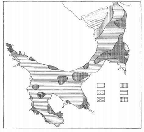
1-24% 25-49% 75-99% 100%
Figure 4.40. Distribution of the ice cover in the White Sea in February. The event rate is given in %. From Hydrometeorology ... (1993).
The distribution of ridges and ridged ice zones in March is shown in Figure 4.42. A vast 2-3-point hummocky zone installs in the major part of Onezhskiy Bay, entire Dvinskiy Bay, the central and eastern parts of the Bassein, Gorlo, and Voronka. Ridged ice (with hummocking up to 3-4 points) occupies the entire Mezenskiy Bay and vast areas in the eastern part of the Voronka. The steady air temperature transition from negative to positive values and the beginning of springtime ice melting occurs in the second 10-day period of April. The first to melt is the young ice covering polynyas and coastal leads. The white ice, prevalent in the sea, is carried by westerly winds away from the Bassein s center to the eastern part of the sea, and further on to the Gorlo and the Voronka under the influence of stable runoff currents and winds. Drifting ice can accumulate in the eastern parts of the Dvinskiy and Mezenskiy Bays, in the Voronka and partly in the Gorlo and thereby become hummocky and ridging. A more rapid process of ice
%. From Hydrometeorology ... (1993).
breaking and melting occurs in May. However, the complete release of the White Sea from ice occurs, as a rule, in the first 10-day period of June. In the text presented above a statistical pattern of ice formation and destruction in the White Sea was demonstrated. The nature of ice processes can doubtless vary from year to year and from month to month. An essential differentiation in ice conditions in the Arctic Basin has been discovered in recent years. During regular satellite SAR surveys, that started from the early 1990s, a significant variability of the ice parameters in the Arctic Seas were revealed (Melentyev et al., 2003a). These observations have been confirmed during the aircraft counts of numbers of the Greenland seals organized in the mid-1990s (Chernook et al., 1998a). To demonstrate the recent modifications of meteorological and ice conditions in the studied region, we have chosen to look at the month of March in two years, viz. 2002 and 2003. According to Chekmasova (2002), the monthly mean temperature in March 2002 in the northern hemisphere was 13.1oC (i.e., 1.6oC higher than the
From Hydrometeorology ... (1991).
climatic norm). At that time, a specific feature of the hydrometeorological and ice conditions of the northern regions of European Russia remained unchanged and characterized by a fast income of warm air masses of North Atlantic origin. The warm air practically prevented the penetration of the cold Arctic air into the continent. As a result, the daily mean air temperature over the major part of European Russia was mostly higher than usual (except for 3-5 days at the end of the month). In some places, on some individual days, the maximum air temperature exceeded the absolute maximum for the daytime. Both in the European and Asiatic parts of Russia, mean monthly air temperatures appeared to be 2-6oC and sometimes even 7-8oC higher than the mean climatic ones (Figure 4.43). Positive temperature anomalies of such an amplitude and scale (over the major part of Russia) are an extremely rare phenomenon. The probability of a positive temperature anomaly over a territory like this one during the last 70 years was only 15-17%, but in the period 1990-2001 it increased sharply and reached 42%.
In March 2002, the weather was characterized by frequent and sharp tempera- ture fluctuations. For instance, at the end of March in the Archangelsk Oblast the air temperatures went down to -30 to -36oC at night, but in the daytime they varied between -6 to +2oC and -6 to -12oC. Strong winds reaching 18-22 m s-1and 24-28 m s-1were observed on most Arctic coasts. These temperature anomalies influenced the ice distribution in the White Sea that was fixed by satellite microwave measurements (Figure 4.44, see color section). The specific features and anomalies of ice conditions in the White Sea and adjacent water basins during the next spring season were also analyzed using tradi- tional hydrometeorological and satellite observations. According to Bogdanova (2003), during the first 10 days of March 2003, in the Murmansk Oblast, the mean air temperature was 5oC above norm. During the second and third 10-day
Figure 4.45. Monthly mean anomalies of air temperature distribution over the Arctic in March 2003. (1) !iT > 2oC; (2) !iT < 0oC. From Bogdanova (2003).
periods of March 2003, the mean air temperature in the Murmansk Oblast and Karelia was 1-2oC above norm (Figure 4.45). In the White Sea, snowstorms were frequent, and the winds were very strong (up to 25m s-1). In the Archangelsk Oblast the wind speed was up to 33 m s-1, whereas on the coastal zone of the Murmansk Oblast the winds reached 36 m s-1. These phenomena affected the distribution of ice cover parameters, as revealed by means of passive microwave remote sensing (Figure 4.46). As we see from the brief summary of the data about ice regime in the White Sea, this region is one of the most adequately studied water areas in the western sector of the Russian Arctic. However, despite the fact that systematic observations of the state of ice cover in the White Sea were started as far back as 1894-1998, the wintertime hydrology and regime characteristics of the ice phenomena in the sea
Figure 4.46. Ice cover mapped by the DMSP SSM/I satellite passive microwave sensor on 17 March, 2003.
have not been studied adequately. A number of problems remain concerning (e.g., the modification of ice cover parameters due to climate variability and change; and ice production and decay (high variability of seasonal ice melt is the specific feature of the ice regime of the White Sea) as investigated on the basis of traditional measurements). In this context, good prospects for further studies of the ice regime can be provided by satellite measurements, particularly using passive and active microwave sensors (see Chapter 6).
Date: 2016-03-03; view: 611
|


 0% 50-74%
 Figure 4.41. Distribution of the ice cover in the White Sea in March. The event rate is given in


 From Chekmasova (2002).
