CATEGORIES:
BiologyChemistryConstructionCultureEcologyEconomyElectronicsFinanceGeographyHistoryInformaticsLawMathematicsMechanicsMedicineOtherPedagogyPhilosophyPhysicsPolicyPsychologySociologySportTourism
Geography
Look at the map. You can see that the United Kingdom of Great Britain and Northern Ireland is situated on the Isles. They are called the British Isles. There are more than 5000 small islands there. Two of them are the biggest: Great Britain and Ireland. We know that the UK consists of 4 countries: England, Wales, Scotland and Northern Ireland. England, Scotland and Northern Ireland are situated on the largest island which is called Great Britain. Northern Ireland is situated on the smaller one which is called Ireland and occupies the northern part of it.
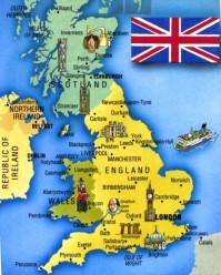
You can see that the UK is washed by water from all sides. It is separated from Europe by the English Channel and the Strait of Dover. It is washed by the Atlantic ocean in the west, by the North sea in the east. The UK is separated from the Ireland by the Irish sea. The geographical position flavoured the development of the country as a great sea country.
England occupies the southern part of Great Britain. Scotland is in the north of the island and Wales is in the west of Great Britain and Northern Ireland is in the north-east of Ireland.
The central and the most beautiful part of the county is England. The landscape is diverse. In the north and in the west of the country you can see mountains, but the other area is plain. England has more fertile soil than others. Also there are many lakes in the north-western district which is known as Lake District.
Scotland can be called the country of mountains. The region of the mountains which is known as Highlands is the oldest in the world. The Grampians is the chain of the mountains there. Ben Nevis is the highest peak. There are some other chains: the Pennine in England and the Cumbrian Mountains in Wales.
You will find a lot of forests along the county. But none of them can be called great. The biggest one is Sherwood Forest. It occupies the area in the eastern part of England. Of course, you have heard the legends about it. The most famous is about Robin Hood.
There are many rivers in the UK. But they are not long. The longest one is the Severn which flows in England. The Thames, the Mersey and the Clyde are the most important rivers. They play a great role in British trade and commerce. You can travel by water along the whole country because many of the rivers are connected14 by canals.
London, Glasgow, Liverpool,Birmingham, Manchester and Edinburgh are the largeast cities in the UK. The total area15 of the UK is 224,000 sq km. And the population16 is about 60 million. Its advantageous17 position has made the UK one of the powerful country in the world.
Geography
[Task 1] A. There follows a selection of words describing a range of geographical features. Read each set of notes and decide which country is being described:
India South Africa Nepal Canada Brazil Holland Mexico Japan
1. – a peninsula bounded by a large mountain range in the North – a wide plateau extending to the ocean in the south – unpredictable monsoon climate – population (approximately 750,000,000) concentrated in the northern plains-
2. – enormous forest areas in the interior – coastal mountains in the West – numerous islands off the north coast – lowlands in the north – continental climate, severe inland, more moderate by the sea – total area:3,851,809 square miles –
3. – a wide variety of land and climate – a huge river basin in the north – thickly forested – a vast plateau in the south – densely populated in coastal belt to the East – relatively underdeveloped in central areas beyond the highlands in the South-East – lies on the Equator
4. – consists of four main islands – mountainous and hilly – many active volcanoes – subject to earthquakes, typhoons and tidal waves – extends through many degrees of latitude – the climate, therefore, is very diverse –
5. – located round the mouth of the Rhine and opposite the Thames estuary – a long coastline – most of the country flat and low-lying – large areas in the West and north below sea level – subject to floods – complex network of canals –
6. – mountainous with numerous lakes – varied climate according to altitude, ranging from tropical to temperate to cold – highest point over 18,000 feet (nearly 6,000 metres) – desert in the West – half of the country lies inside the Tropic of Cancer –
7. – to the north the southern slopes of a gigantic mountain chain – tropical forests and jungle – highest peak 8,845 metres – fertile valleys for agriculture in central zone –
8. – most highly developed country in its continent – rich in mineral deposits and other natural resources – large industrialized urban areas round coasts – rural in the interior – rich vegetation, good irrigation -
B. Think of a country you know well and describe some of its most important geographical features. Read the list to your group-mates without naming the country. How fast can they guess?
C. Discussion point: What influence can a country’s physical geography have on the lifestyle, standard of living and quality of life of the population?
Date: 2015-01-02; view: 3342
| <== previous page | | | next page ==> |
| Geography | | | Task 2] Read the following texts and do the tasks that follow them |