CATEGORIES:
BiologyChemistryConstructionCultureEcologyEconomyElectronicsFinanceGeographyHistoryInformaticsLawMathematicsMechanicsMedicineOtherPedagogyPhilosophyPhysicsPolicyPsychologySociologySportTourism
The USA physical geography
The United States is affected by a large variety of natural disasters yearly. Although severe drought is rare, it has occasionally caused major problems, such as during the Dust Bowl (1931-1942), which coincided with the Great Depression. Farmland failed throughout the Plains, entire regions were virtually depopulated, and dust storms ravaged the land. More recently, the western U.S. experienced widespread drought from 1999-2004, and signs of a major, long-term drought across the Great Plains have developed. In the past year, drought has spread from the Southern Plains westward through the Southwest and east along the Gulf Coast to Florida.
The United States also experience, by a large margin, the most frequent and powerful tornadoes in the world. The Great Plains and Midwest, due to the contrasting air masses, sees frequent severe thunderstorms and tornado outbreaks during spring and summer. The strip of land from north Texas north to Kansas and east into Tennessee is known as Tornado Alley, where many houses have tornado shelters and many towns have tornado sirens. Another natural disaster that frequents the country are hurricanes, which can hit anywhere along the Gulf Coast or the Atlantic Coast as well as Hawaii in the Pacific Ocean. Particularly at risk are the central and southern Texas coasts, the area from southeastern Louisiana east to the Florida Panhandle, the east coast of Florida, and the Outer Banks of North Carolina, although any portion of the coast could be struck. Hurricane season runs from June 1 to November 30, with a peak from mid-August through early October. Some of the more devastating hurricanes have included the Galveston Hurricane of 1900, Hurricane Andrew in 1992, and Hurricane Katrina in 2005. The remnants of tropical cyclones from the Eastern Pacific also occasionally impact the southwestern United States, bringing sometimes heavy rainfall.
Like drought, widespread severe flooding is rare. Some exceptions include the Great Mississippi Flood of 1927, the Great Flood of 1993, and widespread flooding and mudslides caused by the 1982-1983 El Niño event in the western United States. Localized flooding can, however, occur anywhere, and mudslides from heavy rain can cause problems in any mountainous area, particularly the Southwest. Large stretches of desert shrub in the west can fuel the spread of wildfires. The narrow canyons of many mountain areas in the west and severe thunderstorm activity during the monsoon season in summer leads to sometimes devastating flash floods as well, while Nor'Easter snowstorms can bring activity to a halt throughout the Northeast (although heavy snowstorms can occur almost anywhere).
The West Coast of the continental United States and areas of Alaska (including the Aleutian Islands, the Alaskan Peninsula and southern Alaskan coast) make up part of the Pacific Ring of Fire, an area of heavy tectonic and volcanic activity that is the source of 90% of the world's earthquakes. The American Northwest sees the highest concentration of active volcanoes in the United States, in Washington, Oregon and northern California along the Cascade Mountains. There are several active volcanoes located in the islands of Hawaii, including Kilauea in ongoing eruption since 1983, but they do not typically adversely affect the inhabitants of the islands. There has not been a major life-threatening eruption on the Hawaiian islands since the 17th century. Volcanic eruptions can occasionally be devastating, such as in the 1980 eruption of Mount St. Helens in Washington.
The Ring of Fire makes California and southern Alaska particularly vulnerable to earthquakes. Earthquakes can cause extensive damage, such as the 1906 San Francisco Earthquake or the 1964 Good Friday Earthquake near Anchorage, Alaska. California is well known for seismic activity, and requires large structures to be earthquake resistant to minimize loss of life and property. Outside of devastating earthquakes, California experiences minor earthquakes on a regular basis.
Other natural disasters include: tsunamis around Pacific Basin, mud slides in California, and forest fires in the west.
The USA physical geography
The contiguous United States may be divided into seven broad physiographic divisions: from east to west, the Atlantic–Gulf Coastal Plain; the Appalachian Highlands; the Interior Plains; the Interior Highlands; the Rocky Mountain System; the Intermontane Region; and the Pacific Mountain System. An eighth division, the Laurentian Uplands, a part of the Canadian Shield, dips into the United States from Canada in the Great Lakes region. It is an area of little local relief, with an irregular drainage system and many lakes, as well as some of the oldest exposed rocks in the United States.
The Atlantic–Gulf Coastal Plain begins at Cape Cod and Long Island (moraines and outwash plains) and contains southeastern Atlantic and Gulf continental shelf – includes all of Florida and Louisiana. It is low and flat.
The Appalachian Highlands sweeping from Newfoundland to Alabama dominate the landscape of the Eastern seaboard. Their peaks, ridges, hills, and valleys form a belt almost 3,200 kilometers long and up to 580 kilometers wide.
The Interior Plains may be divided into two sections: the fertile central lowlands, the agricultural heartland of the United States; and the Great Plains, a treeless plateau that gently rises from the central lowlands to the foothills of the Rocky Mountains.
The Interior Highlands are located just West of the Mississippi River between the Interior Plains and the Gulf Coastal Plain. This region consists of the rolling Ozark Plateau to the north and the Ouachita Mountains, which are similar in structure to the ridge and valley section of the Appalachians, to the east.
The Rocky Mountain System is a geologically young and complex system that extends into northwest United States from Canada and runs south into New Mexico. There are numerous high peaks in the Rockies; the highest is Mountain Elbert (4,399 m). The Rocky Mountains are divided into four sections – the Northern Rockies, the Middle Rockies, the Wyoming (Great Divide) Basin, and the Southern Rockies. Along the crest of the Rockies is the Continental Divide, separating Atlantic-bound drainage from that heading for the Pacific Ocean.
The Intermontane Region is between the Rocky Mountains and the ranges to the west. It is an arid expanse of plateaus, basins, and ranges. The Columbia Plateau, in the north of the region, was formed by volcanic lava and is drained by the Columbia River and its tributary the Snake River, both of which have cut deep canyons into the plateau. The enormous Colorado Plateau, an area of sedimentary rock, is drained by the Colorado River and its tributaries; there the Colorado River has entrenched itself to form the Grand Canyon, one of the world’s most impressive scenic wonders. West of the plateaus is the Basin and Range province, an area of extensive semidesert.
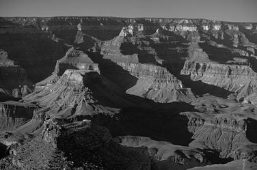
the Grand Canyon
The Pacific Mountain System is between the Intermontane Region and the Pacific Ocean. It is a series of ranges generally paralleling the coast, formed by faulting and volcanism. The Cascade Range, with its numerous volcanic peaks extends south from southwest Canada into northern California, and from there is continued south by the Sierra Nevada, a great fault block. Mountain Whitney (4,418 m), in the Sierra Nevada, is the highest peak in the contiguous United States.
Alaska contains some of the most dramatic and untapped scenery in the country. Tall, prominent mountain ranges rise up sharply from broad, flat tundra plains. On the islands off the south and southwest coast are many volcanoes. Hawaii, far to the south of Alaska in the Pacific Ocean, is a chain of tropical, volcanic islands, popular as a tourist destination for many from East Asia and the mainland United States.
3.1. The USA major rivers and lakes
The longest river in the United States is the Missouri River*. The Missouri River starts in Montana and covers 4 090 km before flowing into the Mississippi River, the second longest river in the United States. The Mississippi (3 770 km) flows to the south and empties into the Gulf of Mexico at New Orleans.
The Missouri-Mississippi river system is the third longest river in the world.
Another important river of the United States is the Hudson River which flows across the northeastern part of the country and empties into the Atlantic Ocean at New York.
The rivers in the west of the country are unsuitable for navigation because they flow through deep canyons and are cut by numerous rapids, which fact, however, makes them a good source of electric power. These rivers start in the Cordilleras and empty into the Pacific Ocean. The largest among them are the Columbia River and the Colorado River.
World-famous is the region of the Great Lakes, situated in the north-east of the United States bordering Canada. It is a system of five great lakes (Lake Superior, Lake Michigan, Lake Huron, Lake Erie and Lake Ontario) joined together by natural channels. These are fresh lakes. Lake Superior is the largest lake that’s partly in the United States at 82 413 km2. The largest lake entirely contained in the United States is Lake Michigan, 58 016 km2.
Great Salt Lake, located in the northern part of the U.S. state of Utah, is the largest salt lake in the western hemisphere. Although it has been called “America’s Dead Sea”, the lake provides habitat for millions of native birds, brine shrimp, shorebirds, and waterfowl.
3.2. The USA major mountains ranges
The country has three major mountain ranges. The Appalachians extend from Canada to the state of Alabama, a few hundred miles west of the Atlantic Ocean. They are the oldest of the three mountain ranges, and offer spectacular sightseeing and excellent camping spots. The Rockies are the highest in North America, extending from Alaska to New Mexico, with many areas protected as national parks. They offer hiking, camping, and sightseeing opportunities. The combined Sierra Nevada and Cascade ranges are the youngest. The Sierras extend across the “backbone” of California, with sites such as Lake Tahoe and Yosemite National Park, then give way to the even younger volcanic Cascade range, with some of the highest points in the country.
The highest mountain in the USA is Denali/Mountain McKinley (6,194 m) in south central Alaska.
Date: 2015-01-02; view: 3149
| <== previous page | | | next page ==> |
| Natural disasters | | |