CATEGORIES:
BiologyChemistryConstructionCultureEcologyEconomyElectronicsFinanceGeographyHistoryInformaticsLawMathematicsMechanicsMedicineOtherPedagogyPhilosophyPhysicsPolicyPsychologySociologySportTourism
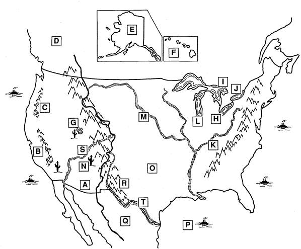
THE GEOGRAPHY OF THE UNITED STATES
A. The Geography of the United States
The United States is the fourth largest country in the world in land area. Forty-eight of the fifty states are in the middle of the North American continent between the Atlantic Ocean on the east and the Pacific Ocean on the west. It is about 3000 miles (4800 kilometers) from the east coast to the west coast and about 1500 miles (2400 kilometers) from the Canadian border on the north to the Mexican border on the south. The island state of Hawaii is in the Pacific Ocean, and the state of Alaska is northwest of Canada.
The map on the next page shows the geography of the United States. The two main mountain ranges run north and south—the Appalachian Mountains in the eastern part of the United States and the Rocky Mountains in the west. Between them are the Great Plains. There is another mountain chain west of the Rockies—the Sierra Nevada and the Cascade ranges.
The longest river in the United States is the Mississippi. The Missouri and Ohio Rivers flow into the Mississippi, and the Mississippi flows south into the Gulf of Mexico. The major rivers in the western part of the United States are the Colorado and the Rio Grande. The highest mountains of the Rockies form the Continental Divide. Rivers to the east of the divide flow east, and rivers to the west of it flow into the Pacific Ocean.
The Great Lakes on the northern border of the country are Lake Superior, Lake Michigan, Lake Huron, Lake Erie, and Lake Ontario. The Great Salt Lake is in a desert area in the western part of the United States. The Mojave, the Gila, and the Painted Deserts are in the southwestern part of the country.
B. Write О for oceans, M for mountains, R for rivers, L for lakes, and D for deserts.
1. M the Appalachians 8. _ the Ohio
2. _ the Atlantic 9. _ the Pacific
3. _ the Sierra Nevada Range 10. _ the Rockies
4. _ Superior 11. _ the Cascade Range
5. _ the Mojave and the Gila 12. _ the Missouri
6. __ Michigan and Huron 13. __ the Mississippi
7. _ the Colorado 14. _ Erie and Ontario
C. Write T for true and F for false. Correct the false sentences.
1. _F_ In land area, the United States is the largest country in the world.
2. __ All the states except Hawaii and Alaska are together on the North American continent between the Atlantic and Pacific Oceans.
3. __ It is farther from the Canadian border to the Mexican border than from the east coast to the west coast.
4. __ The two main mountain ranges in the United States are the Hurons and the Eries.
5. __ Between the mountain chains are the Great Plains, and there is also a low plain along the Atlantic Ocean.
6. __ The longest river in the United States is the Gulf of Mexico.
7. __ The rivers west of the Rockies flow into the Pacific Ocean, and the rivers east of the Rockies flow east.
8. __ The five Great Lakes are in the southwestern part of the country.
9. __ The Mojave Desert is west of the Mississippi River.
10. __ The Great Salt Lake is south of the Sierra Nevada and Cascade Mountains.

D. Use the Scale of Miles on the map. Write the shortest distances between:
1. the Atlantic Ocean and the Pacific Ocean: _________________________________
2. the Canadian and the Mexican borders: ___________________________________
3. the Appalachian and the Rocky Mountains: ________________________________
4. The Rocky Mountains and the Sierra Nevada: ______________________________
5. The Mississippi and the Colorado Rivers: __________________________________
6. Lake Michigan and the Gulf of Mexico: ___________________________________
7. The Great Salt Lake and the Rio Grande: __________________________________
8. The Mojave and the Gila Deserts: ________________________________________
E. Write the letters from the map on the lines.
1. D Canada 11. _ the Cascade Mountains
2. _ Mexico 12. _ the Sierra Nevada
3. _ Alaska 13. _ the Great Plains
4. _ the Hawaiian Islands 14. _ Lake Huron
5. __ the Gulf of Mexico 15. __ Lake Erie
6. _ the Ohio River 16. _ Lake Ontario
7. __ the Missouri River 17. __ Lake Michigan
8. _ the Colorado River 18. _ the Great Salt Lake
9. _ the Rio Grande 19. _ the Painted Desert
10. __ the Rocky Mountains 20. __ the Gila Desert
Date: 2015-01-02; view: 5608
| <== previous page | | | next page ==> |
| AMERICAN SYMBOLS | | | The History of Immigration |