CATEGORIES:
BiologyChemistryConstructionCultureEcologyEconomyElectronicsFinanceGeographyHistoryInformaticsLawMathematicsMechanicsMedicineOtherPedagogyPhilosophyPhysicsPolicyPsychologySociologySportTourism
World Trends
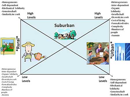
Figure 2. Graphic Depiction of Rural, Suburban, and Urban Societal Characteristics
© 2009 Ron J. Hammond, Ph.D.
The 2008 Population data Sheet from the www.PRB.org website stated, "The world will pass a milestone in 2008: One-half of the world's residents will live in urban areas. This event is impressive when we consider that less than 30 percent lived in urban areas in 1950 (page 5)." Look at Figure 3 below to see NASA's amazing time-lapsed, night time photograph of the Americas, Western Europe, and Western Africa. From this satellite photograph you can see the population concentrations throughout the US, South America and Western Europe in contrast to the relatively sparsely lit Western Africa. This not only represents fewer numbers, but also less utilization of rather expensive electrical lights in the urban areas. You can barely distinguish Canada from the US. This is because most Canadians live in the lower portion of the country where the climate is more conducive to human existence.
Figure 3. NASA's Photograph of Americas, Western Europe, and Western Africa*
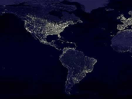
*Used by Permission of NASA, 1995
In Figure 4 you can see the NASA night photo of the rest of the world (not including the north and south continents). On the left side of the photograph it becomes obvious that most of Africa is not as lit up as are the other regions of the world. There are nearly 800 million people currently living in Africa. Electricity and city lights are very expensive based on the standard of living there. Notice the lights of Europe, Russia, The Middle East, India, Eastern China and Asia, the Island nations and the outer boundary of Australia. These light concentrations are in and near major cities and photographically distinguish the differences in socio-economic status between these regions of the world. They also identify the world's urban areas in a clear way.
Figure 4. NASA's Photograph of Africa, Europe, Middle East, Russia, Asia, Australia, and Island Nations*
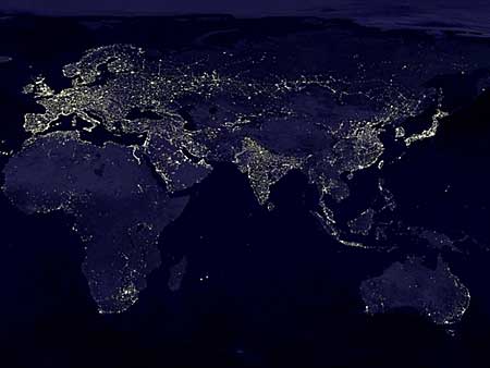
*Used by Permission of NASA, 1995
Look again at the United States in Figure 3. You can see a massive cluster in the North-eastern region. The clusters represent what sociologists call a Megalopolis, which is an overspill of one urban area into another often where many small towns grow into one huge urban area connected by a major transportation corridor. Some of the larger ones today include: Boston-Washington; Chicago-Pittsburgh; and New York-New Jersey. A megalopolis often has 10 million or more people living there. These are found in Europe, Asia, India, Mexico, and Japan. A megalopolis is comprised of Metropolitan Areas, or large population concentrations in cities which have influence of the city's various zones. Each city has a number of zones of influence within its boundaries.
Date: 2015-02-28; view: 1656
| <== previous page | | | next page ==> |
| The United States Road System | | | Theories of Urban Development |