CATEGORIES:
BiologyChemistryConstructionCultureEcologyEconomyElectronicsFinanceGeographyHistoryInformaticsLawMathematicsMechanicsMedicineOtherPedagogyPhilosophyPhysicsPolicyPsychologySociologySportTourism
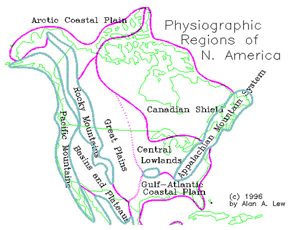
Western Mountain and Basin Regions
The three major physiographic regions in the western US are: (1) the Rocky Mountains, (2) the Intermountain Basin and Plateaus region (the largest and oldest part of the West), and (3) the Pacific Coast Mountain and Valley region. The mountainous West was created by the rapid speed with which North America moved westward into and over the Pacific Ocean Plate. The Intermountain Basin and Plateaus region was the first portion to be uplifted, creating a large mountain range through present-day Nevada some 80 million years ago. The Rocky Mountains were formed 60 million years ago. Today, the Front Range of the Rockies still rises a mile above the Great Plains at Denver (Colorado).
The Rocky Mountains
The Rocky Mountains contain a mix of sedimentary, igneous, and metamorphic rock. Late in Cretaceous times (about 70 million years ago), tremendous mountain-building processes disturbed the western half of the continent where a long series of sedimentary beds lay evenly spread over the ancient continental floor. This disturbance was accompanied by volcanic activity and is known as the Laramide Revolution. It resulted in a great uplift of the sedimentary beds, folding and faulting, and metamorphic changes. The uplift was followed by the erosion of the sedimentary layers and exposure of the underlying igneous rock. In some places, the cover was preserved, usually in pockets formed by downfaulting. This diversity gives the West its varied and interesting physiography. The Rockies include the Brook Range in Alaska, the Canadian Rockies, the Northern Rockies (Idaho and Montana), the Central Rockies (Colorado), and the Southern Rockies (New Mexico). The highest peaks rise to over 14,000 feet.
The Rockies are breached in only a few places. In the far north, the Lizard River flows through a break in the Mackenzie Mountains. There is another break between the Northern and Central Rockies where the Wyoming Basin is formed. Here, the old Oregon Trail made use of the route, so that wagons could traverse the continental divide at about 7,000 feet.
Climate in the Rocky Mountains is generally cold in the winter and mild in the summer. Highland climates, however, are difficult to classify because of great variation from valley floors to mountain peaks. In addition, south-facing slopes which receive much sunshine can be very different from colder, north-facing slopes in climate and vegetation. Latitude plays a major role as the mountain chains existing farther to the north are much colder and have more permanent snow and active alpine glaciers than those to the south.
The Western Plateaus
West of the Rockies lies an area whose astonishing physical features are the product of crustal faulting, volcanic activity, and intense recent erosion and downcutting by rivers. The basic form of this region is that of a series of high elevation plateaus. In the southwest, these plateaus are flat and descend in an almost step-like fashion from the Rocky Mountains into the Great Basin. The vast plateau in the northwest was shaped by volcanic activity, while in Canada the plateaus are narrow, steep, and mountainous until they open into the rolling hills of interior Alaska.
The development of these plateaus, like that of the Rockies, resulted from the Laramide Revolution. Their different levels are the result of faulting. The two main plateaus of the West are the Colorado Plateau and the Columbia Plateau. The Colorado plateau covers portions of Colorado, Utah, Arizona, and New Mexico. It is composed of relatively flat sedimentary rock that was uplifted. The Colorado River cuts the Grand Canyon through this uplifted sedimentary rock. The Columbia Plateau is located in eastern Washington and parts of Oregon and Idaho. It is composed of lava flows that combine to be several thousand feet thick. Hells Canyon, on the Snake River between Oregon and Washington, is the deepest gorge in the US and is cut into this plateau.
The climate of the plateaus varies with latitude (those farther north are colder) but they generally have a hot summer and mild to cold (depending on elevation) winter. Precipitation is typically under 10 inches a year (although it reaches 20 inches on the Fraser Plateau). Runoff from the surrounding mountain peaks provides a major source of water for irrigated farm fields, which often do well. The Columbia Plateau is one of the richest producing irrigated wheat regions on the continent.
The Western Plateaus in Canada and Alaska
The Fraser Plateau comprises much of central British Columbia, situated between a narrow band of the Rockies and the Canadian Coast Mountains. Like the Columbia Plateau to the south, it is comprised of large areas of extrusive igneous lava. The entire plateau is drained by the Fraser River, which enters the sea at Vancouver. North of here the Plateau region becomes narrow and is bisected by rivers cutting through mountains composed of a mixture of various rocks of different ages and composition. The older of these rocks is the source of the gold that was first discovered in the Yukon Territory of Canada in the late 1800s. The Klondike gold region sits astride the Yukon Plateau and the Yukon Interior (a northern basin and range-like region in Alaska). The Yukon Interior reaches over 500 miles in width in western Alaska.
The Great Basin and the Great Salt Lake
At the western edge of the Colorado Plateau lies a great fault line at the base of the Wasatch Mountains. West of this lies the Great Basin, which stretches for 500 miles from north to south and east to west. Waters flow into, but not out, of the Great Basin. The Great Basin is centered on Nevada and is composed of the caved-in remnants of a pre-Rockies mountain system which was formed 80 million years ago. Numerous faulted mountain blocks run north and south through the Great Basin, with areas between these ranges consisting of unconsolidated alluvium. This basin and range landscape also extends into southern California, Arizona, and New Mexico. The Great Salt Lake occupies some 2,000 square miles of the eastern edge of the Great Basin. It is the remnant of the former Lake Bonneville, which was 10 times larger at the end of the last ice age.
Rainfall is generally under 5 inches throughout the basin and range deserts of the American West. Irrigated fields rely on water from the plateaus and higher peaks. Groundwater is another important source of irrigation, although it is becoming more and more difficult to reach as water tables drop. Most of the rain that does fall comes in the summer months, from moisture originating in the Gulf of California and the Gulf of Mexico. Altitudinal zonation on the higher mountains is well pronounced, as one can often travel from desert to tundra within a hundred miles.
The Pacific Coast Mountains and Valleys
The Pacific Coast province is very diverse. Within it are found the highest points and the last remaining active volcanoes on the continent. Like the rest of the mountainous West, the Pacific Coast portion was also shaped by plate tectonic activity. The granite peaks of the Sierra Nevada Mountains in California are an exposed intrusive igneous formation, while the Cascade Range to the north are of extrusive igneous (lava) origin. Farther to the north, Canada's Coast Mountains and the Alaska Range (in Alaska) are intrusive igneous formations, similar to the Sierra Nevada. The Coast Mountains are the world's highest coastal mountain system, while the Alaska Range contains the highest mountains on the continent, including McKinley (also known as Denali) at 20,320 feet.
Pacific Ring of Fire*
Subduction
Both intrusive and extrusive igneous rock come from Pacific Ocean sea floor plates that have been pushed under the North American plates, a process known a subduction. The ocean plates melted and the molten magma then rose to form the Alaska Range, Coast Mountains, Sierra Nevada, and Cascade Range. (A similar process pushed up the Rocky Mountains and Colorado Plateau.) As these mountains were uplifted, the area immediately to their west was sunken to form a depression. The depression originates as the Gulf of California in Mexico and continues as the Central Valley in California, the Willamette Valley in Oregon, the Puget Sound lowland in Washington, the coastal straits of British Columbia, and the Alexander Archipelago in the Alaska Panhandle.
The Coast Range: Lateral Faulting and Earthquakes
Along the Pacific shoreline of California, Oregon, and Washington, the low-lying Coast Range is formed by the crumpling edge of the North American continent. The continued subduction of a small ocean plate under Oregon and Washington ensures volcanic activity in the Cascades. In California, however, the North American Plate is sliding sideways against the large Pacific Ocean Plate. This causes lateral or strike-slip faulting throughout the Coast Range of California. The Pacific Plate moves northward at about 2 inches a year, causing an ever present danger of serious earthquake activity. The Coast Range continues as Baja California in the south and Vancouver Island and Queen Charlotte Island in the north. The Alaska Peninsula, which contains more active volcanoes than anywhere else on the continent, could also be considered an extension of this coastal edge.
Unlike the eastern trailing coastline, the western coasts are all leading coastlines. They are steep and show signs of emergence--i.e., rising up out of the sea with older coastlines now hundreds of feet in the air.
Mediterranean and Marine West Coast Climates
California is famous for its Mediterranean climate. This climate exhibits a distinct summer dry and winter wet pattern, which is different from that found anywhere else in the US or Canada. This climate gradually changes to the Marine West Coast climate as one moves north through Oregon and into Washington. The Marine West Coast climate is wet all year round, although it, too, has a winter peak. The main air masses creating these climates are a north Pacific low pressure system, which bring cool and moisture storms, and a mid-Pacific high pressure system, which brings dry air to the coast of California. These two air masses move north in the summer and south in the winter. Because the moisture hitting the West Coast comes off the ocean, it has a moderating maritime influence, with coastal snow being uncommon, except in northern British Columbia and Alaska.
West Coast Rainshadows
The two north-south mountain systems on the West Coast create two rainshadow patterns. The first, smaller rainshadow occurs in the inland valleys of California, Oregon, and Washington and the coastal channels of British Columbia. Thus, Sacramento, Portland, Seattle, and Vancouver (British Columbia) all lie in a warmer and less rainy rainshadow area. A more significant rainshadow exists east of the Sierra Nevada, Cascade Range, and Canada's Coast Mountains. This rainshadow extends the naturally occurring deserts of the southwestern US far north to the Canadian border. In Canada and Alaska, the dry polar desert is extended southward by the same rainshadow process behind the Coast Mountains. Dry rainshadow conditions also extend into Alaska, where the north-south mountains shift to an east-west moisture barrier in the Alaska Range.
Date: 2015-02-16; view: 4708
| <== previous page | | | next page ==> |
| Folding and the Ozarks | | | Population of the USA |