CATEGORIES:
BiologyChemistryConstructionCultureEcologyEconomyElectronicsFinanceGeographyHistoryInformaticsLawMathematicsMechanicsMedicineOtherPedagogyPhilosophyPhysicsPolicyPsychologySociologySportTourism
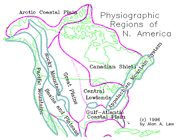
Physical Provinces of Anglo North America
Overview
Anglo North America is defined as that part of the North American continent comprised primarily by the US and Canada. This area comprises almost 7.5 million square miles and extends over 50 degrees of latitude from the Florida Keys to the Queen Elizabeth Islands in northernmost Canada. The distance from Newfoundland in the east to San Francisco in the west is more than 3,300 miles. North America can be divided into three physically distinct sections, each of which has important physical geography divisions within it. These are
1. The Eastern Lowlands
the Central or Interior Lowlands,
the Great Plains, and
the Canadian Shield.
2. The Eastern Mountain System
the Appalachian Mountains, and
the Ozark Plateau.
3. The Western Mountains and Basins
the Rocky Mountains, the Intermountain Basins and Plateaus, and
the Pacific Coast Mountains and Valleys.
North America's Physiographic Regions (Map)
Eastern Lowland Landscapes
Over half of the US, and even more of Canada, is flat land. The largest expanse of flat land is located between the Appalachian Mountains in the East and Rocky Mountains in the West. This vast Interior Lowland stretches from the Gulf of Mexico in the south to Hudson Bay in the north. The southern and eastern portions of the Eastern Lowlands consist of the Gulf and Atlantic Coastal Plains, which wrap around the eastern mountains in a gradual slope to the sea. The northernmost portion of the Interior Lowland is the 4-billion-year-old igneous rock of the Canadian Shield. Between the Great Lakes and the Gulf Coastal Plain is the Central Lowlands of the Midwest and Great Plains. This area is higher in elevation and consists of more consolidated sedimentary rock. All three of these areas are very flat.
The Gulf and Atlantic Coastal Plains
The Gulf Coastal Plain faces the Gulf of Mexico, while the Atlantic Coastal Plain borders the Atlantic Ocean. Together, these two plains wrap around the southern end of the Appalachian Mountains, filling in an area that was under water up until only 75 million years ago. This is the flattest of the Interior Lowlands subregions. In Texas, these plains are 300 miles wide. Northeastward, from the Florida Peninsula, they gradually narrow as more of the plain is under the sea. Near New York, the plain comes to an end--reappearing north of the Hudson only in parts of Cape Cod and the islands off the coast of southern New England.
These plains are also among the youngest in the US. When the Rocky Mountains were first beginning to rise some 70 million years ago, most of the Gulf and Atlantic Coastal Plains were under water. The coastal plains were gradually built up by unconsolidated (and easily eroded) sediments washed out from the Appalachian Mountains, the Central Lowlands, and the Great Plains. Successive layers of sedimentation form belts with low scarp edges facing inland, but the general slope of the plains' surface is very gentle and no true coastline is formed. Instead, swamps (wet forests), marshes (wet grasslands), and lagoons are fronted by almost continuous sand bars and reefs, which characterize a transition zone between land and sea. Deposits of coastal marine life in these areas is the basis for vast reservoirs of oil and natural gas.
The climate throughout this region is humid subtropical, with summer rainy seasons. Annual rainfall is over 40 inches for the entire coastal plains area, with some areas reaching over 60 inches at the southern extremes. Temperatures are moderate in the winter and hot in the summer. The major air mass which influences the climate of this region comes from the south, bringing warm and moist tropical air. In the spring, this southerly flow may come in the form of hurricanes. This air mass is weaker in the winter, and occasional Arctic air masses reach deep into the South, often destroying the region's fruits and vegetables. The heavy precipitation washes out many of the nutrients in the soils, creating low nutrient ultisols. Vast areas of needleleaf evergreens make the lowland South one of the two major timber-producing regions in the US.
The Florida Peninsula and Mississippi River Valley
Florida lies entirely within the Gulf and Atlantic Coastal Plains. It is entirely flat (the highest elevation is 345 feet), is mostly sandy, and has large swamp areas. The southern tip is dominated by the 5,000-square-mile Everglades swamp. The coastal plains spread inland to include the Mississippi River Valley as far north as Cairo, IL., at the confluence of the Mississippi and Ohio Rivers. The Mississippi Valley is wide and flat, and the heavy silt load of the river continues to build its delta as the river empties into the Gulf.
East Coast Trailing Coastline Landscape
A shallow shelf extends up to 250 miles from the coastline to the edge of the North American continent. This situation is known as a "trailing coastline," because it is often found on the side of the continent that is trailing behind a migrating continent. North America is moving westward, toward the Pacific Ocean and away from the Atlantic Ocean.
Date: 2015-02-16; view: 6523
| <== previous page | | | next page ==> |
| Climate and Biogeography | | | The Central Lowlands and Great Plains |