CATEGORIES:
BiologyChemistryConstructionCultureEcologyEconomyElectronicsFinanceGeographyHistoryInformaticsLawMathematicsMechanicsMedicineOtherPedagogyPhilosophyPhysicsPolicyPsychologySociologySportTourism
Air Masses in the Western US
The Rockies and prevailing west-to-east winds keep most of the tropical and polar air masses in the eastern US. The western US is primarily influenced by the desert-creating high pressure system in the Southwest, and the upper latitude humid low pressure system in the Northwest. In the winter, the low pressure storms from the northwest occasionally migrate as far south as the Mexican border. Most of the rainfall in the Southwest, however, comes in the summer months from humid equatorial low pressure systems originating in either the Gulf of Mexico or the Gulf of California. Unlike in the nation's midsection, these seldom penetrate deeper than the border states of Arizona and New Mexico.
Surface Physiography: Altitudinal Zonation and Rainshadows
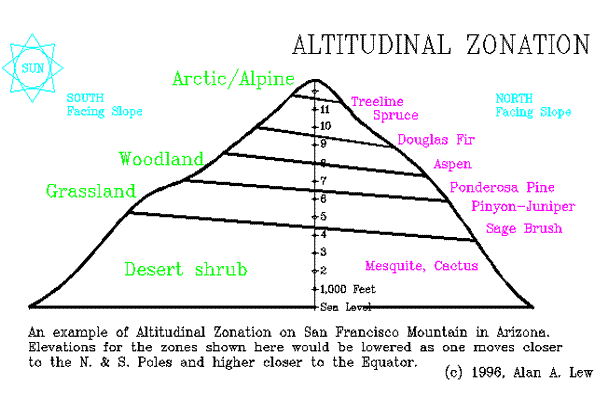
One of the two ways that surface physiography influences climate is through altitudinal zonation. "Altitudinal zonation" results from the fact that higher elevations are colder than lower elevations. As one moves up a high mountain slope, the climate and resulting vegetation change from warmer to colder weather types. The effect is similar to moving from lower to higher latitudes (i.e., from the equator to the poles). Altitudinal zonation is most pronounced in the southwestern US, where mountain peaks stand out as lush islands in a sea of desert.
Altitudinal Zonation (diagram)
The second way that physiography influences climate is through the creation of a "rainshadow." Water molecules slow down when the air gets colder, allowing condensation and clouds to form. When the temperature is warmer, the molecules warm up and move faster, and the clouds dissipate. As a mass of warm air rises into an area of colder air, it will eventually cool to a temperature at which condensation will occur and a cloud will form. This is known as the "dew point" temperature. If the air mass continues to rise and cool, condensation increases until precipitation (rain, snow, hail, etc.) occurs.
This process takes place regularly in the Cascade Range (in Oregon and Washington) and Sierra Nevada Range (in California). Air masses are pushed up the western side of the mountains in a process known as 'orographic uplift'. This cools the air and typically results in precipitation (rain or snow). By the time the air mass reaches the top of these ranges, it has lost much of its original moisture. The air mass then starts down the back side of the mountain. This causes the air to warm up and the molecules to speed up, with the result that the clouds disappear and the little moisture that is left is now spread out over a wider area. We say that the downwind side is in the "rainshadow" of the mountain. The deserts of the Southwest extend as far north as eastern Washington because of this rainshadow effect. In Hawaii, the wet side of an island is referred to as its "windward" side, while the dry, rainshadow side is known as the "leeward" or "lee" side.
Date: 2015-02-16; view: 4772
| <== previous page | | | next page ==> |
| Glacial Till and Moraines | | | Climate and Biogeography |