CATEGORIES:
BiologyChemistryConstructionCultureEcologyEconomyElectronicsFinanceGeographyHistoryInformaticsLawMathematicsMechanicsMedicineOtherPedagogyPhilosophyPhysicsPolicyPsychologySociologySportTourism
Destin, Florida
| Destin, Florida | |
| |
| Nickname(s): The World's Luckiest Fishing Village | |
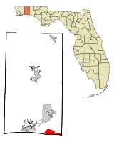 Location in Okaloosa County and the state of Florida
| |
Coordinates:  30°23′36″N 86°28′31″W / 30.39333°N 86.47528°W / 30.39333; -86.47528Coordinates: 30°23′36″N 86°28′31″W / 30.39333°N 86.47528°W / 30.39333; -86.47528 30°23′36″N 86°28′31″W / 30.39333°N 86.47528°W / 30.39333; -86.47528Coordinates: 30°23′36″N 86°28′31″W / 30.39333°N 86.47528°W / 30.39333; -86.47528
| |
| Country | United States |
| State | Florida |
| County | Okaloosa |
| Government | |
| • Mayor | Sarah "Sam" Seevers |
| Area | |
| • Total | 8.2 sq mi (21.2 km2) |
| • Land | 7.5 sq mi (19.5 km2) |
| • Water | 0.6 sq mi (1.7 km2) |
| Elevation | 26 ft (8 m) |
| Population (2010) | |
| • Total | 12,305 |
| • Density | 1,477.1/sq mi (543.500/km2) |
| Time zone | CST (UTC-6) |
| • Summer (DST) | CDT (UTC-5) |
| ZIP codes | 32540-32541 |
| Area code(s) | |
| FIPS code | 12-17325[1] |
| GNIS feature ID | 0281516[2] |
| Website | www.cityofdestin.com |
 Seal
Seal
Destin is a city located in Okaloosa County, Florida. It is a principal city of the Fort Walton Beach-Crestview-Destin, Florida Metropolitan Statistical Area.
Located on Florida's Emerald Coast, Destin is known for its white beaches and emerald green waters. Originating as a small fishing village, it is now a popular tourist destination – according to the Florida Department of Environmental Protection, over 80 percent of the Emerald Coast's 4.5 million visitors each year visit Destin.[3] The city styles itself "The World's Luckiest Fishing Village",[4][5] and claims to have the largest fishing vessel fleet in the state of Florida.[6]
Destin is named after Captain Leonard Destin, a New London, Connecticut fishing master who settled in the area c. 1845 or 1850. The first condominiums were built in the 1970s, although Destin was not incorporated as a municipality until 1984. The city has experienced rapid growth since the 1980s.
The city is located on a peninsula separating the Gulf of Mexico from Choctawhatchee Bay. The peninsula was originally an island; hurricanes and sea level changes gradually connected the island to the mainland. As of the 1940s it technically became an island again with the completion of the Choctawhatchee-west bay canal.
Date: 2015-02-16; view: 592
| <== previous page | | | next page ==> |
| | | Geography |