CATEGORIES:
BiologyChemistryConstructionCultureEcologyEconomyElectronicsFinanceGeographyHistoryInformaticsLawMathematicsMechanicsMedicineOtherPedagogyPhilosophyPhysicsPolicyPsychologySociologySportTourism
Climate of the White Sea catchment and scenarios of climate and river runoff changes
This chapter expands upon climate and climate-related hydrological variability in the White Sea region, as seen from observations and models. Section 3.1 describes the patterns of climate variability as revealed by a long observational time series. Section 3.2 describes different climatic scenarios and estimates of changes in river runoff, based on new model experiments using the Max-Planck Institute for Meteorology ECHAM4/OPYC3 model.
3.1 CLIMATE
Arctic climate and atmospheric circulation patterns in the White Sea region have been described by Kondratyev as well as by Alekseev et al. (Bobylev et al., 2003). Climate change over the Kola Peninsula and Karelia was discussed by Filatov et al. (Bobylev et al., 2003). This analysis of the regional climate is based on the data from long-term monitoring performed by the State Weather Service (SWS) at weather stations and sites located in various regions of the White Sea watershed area, as well as at observation points located on the marine coast and islands (Figure 3.1). All these measurements were obtained from the Russian Hydrometeorological Service (Roshydromet).
The climatic regime of the White Sea region can be described as intermediate between maritime and continental types. In terms of its origin, it belongs to the Atlantic-Arctic zone of the temperate latitudinal belt. Due to the air masses coming from the Atlantic throughout the year, winters there are relatively warm but lengthy, whereas summers are short and cold. Additional specific climate features include significant cloudiness, high air humidity, abundant precipitation, and generally unstable weather conditions throughout the year. During all seasons, the White Sea is exposed to frequent shifts in overlaying air masses as pressure systems migrate over the water surface. An average year has 215 days
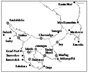
Figure 3.1. Locations of the SWS stations: • =hydrological stations; • = weather stations and sites.
with cyclones (cf. 150-160 cyclonic days in the Moscow area). Intensive cyclonic activity and relatively rapid shifts of synoptic processes create high variability (sometimes within one day) of the values of meteorological elements and parameters. A key factor responsible for the climate formation in the region is the atmo- spheric circulation over the Atlantic/European sector of the northern hemisphere. According to Wangenheim s classification (Girs, 1971), there are several types of atmospheric circulation, namely westerly W , easterly E, and meridional C. The pattern of long-term variability of the hydrometeorological regime has a few features in common with the variability patterns of the prevalent types of atmo- spheric circulation. The intensity of the westerly W form has been slightly decreasing since the early 20th century, causing a minor decrease in river runoff (Smirnova et al., 2001). Importantly, in the 1920s-1930s there was a sharp decrease in the intensity of the westerly circulation, which normally brings moist air masses in to the region. It was the time period between 1929 and 1939 that Girs (1971) described as an E- form era, noted for the lowest precipitation rates. In the following 20 years, the climate became more temperate, and a sharp decline in westerly flows occurred between the 1960s and the early 1970s (36 days in 1976). As a result, the river runoff practically dropped below the norm, and the water level subsided at most
stations.
Since the mid-1970s, the number of days with westerly winds began increasing, being accompanied by a respective increase in the freshwater runoff. With a certain
|
time lag, these processes resulted in a substantial rise in water level as well as in tendencies to a decrease in water salinity and water temperature enhancement in different parts of the sea, which generally lasted until the 1990s (Smirnova et al., 2001).
Since 1985, a positive anomaly of easterly winds (E) has been recorded, and the frequency of the westerly form (W ) has been close to the norm. The discharge of individual rivers to the White Sea, except for the Mezen River, and the total river runoff exhibited positive anomalies.
The air temperature and atmospheric pressure in different parts of the White Sea can also be used to illustrate the specific features of the contemporary meteorological regime. In the late 1980s, negative anomalies of air temperature were superseded by positive anomalies (up to 2.0-2.5oC). Correspondingly, the sign of the atmospheric pressure anomaly changed from positive to negative.
The reduction in atmospheric pressure is due to increased westerly flows and significantly intensified cyclonic activity, whereas the warm air masses arriving from the Atlantic Ocean increase the air temperature. In general, however, the positive anomalies of the air temperature in the second-half of the 1980s and the early 1990s were rather low, whereas the negative anomalies of the atmospheric pressure proved to be more significant.
According to Wangenheim s classification, the White Sea falls into the zone of prevalent westerly winds (W -circulation), where a zonal air movement (i.e., the west- to-east transport of air masses) is typical. This is the direction in which baric systems displace from Greenland and Iceland to the Barents and White Seas. As it passes over Fennoscandia, the Atlantic air masses cool down, generating substantial air temperature differences between the eastern and western coasts of the White Sea. The air temperature at the land surface of the eastern coast is normally lower than that on the western coast. This pattern can be broken, however, by incursions of cold air masses from the north (C-circulation). Recently, the annual number of days with easterly winds has increased, contributing to a rise in the mean annual air tempera- ture over East Fennoscandia (Filatov, 1997).
Based on the movement of low-pressure systems over more than a 50-year period, cyclones can be grouped into dipping , westerly, southerly, and abnormally moving. Inzhebeikin (2001) wrote that in the case of westerly cyclones, the mechanisms of storm surge generation by this type of cyclone differs significantly depending on whether the core of the cyclone passes over the Barents Sea or the White Sea (or to the south of the latter). The cyclones ascribed to westerly ones are therefore classified in this chapter as the Barents Sea westerly and White Sea westerly cyclones. Cyclones usually migrate over the White Sea or the Barents Sea from west to east with a cycle of 4-6 days. The frequency of the dipping and westerly cyclones is ca 88%. Cyclones of this type most often originate in the central parts of European Russia and, while deepening, migrate northward to pass the eastern or south-eastern part of the White Sea. The pathways of abnormally moving cyclones are quite diverse. Cyclones of this type typically involve northerly winds that generate sea surface level (SSL) set-ups in southern parts of the sea without reaching maximum values, and SSL drops in northern areas caused by wind-driven currents.
Let us consider synoptic-scale processes against a background of atmospheric macro-circulation processes. In summer, low-pressure systems from the Atlantic bring rainfall and reduce the mean air temperature. Winter incursions of cold air coming from the Arctic to the rear of transient cyclones yield clear, but colder weather. In winter, Atlantic air masses attenuate frosts and cause periods of warming. As a result of studying circulation processes in the White Sea area (Table 3.1), the following types of weather were identified (White Sea Sailing Directions, 1983):
1 South-west (SW) cold winter type. This type is typical of the winter monsoon. It forms when a high-pressure system is present south of the White Sea with a simultaneous development of cyclonic activity over the Barents Sea. There are prevailing south-westerly winds with a velocity of 5-9 m s-1. The lowest air temperature is recorded in February (-14oC).
2 North (N) winter type. This is typical of rear and core parts of depressions located over eastern and south-eastern parts of the Barents Sea. Cold Arctic air masses pass over a relatively warm, ice-free surface of the Barents Sea, getting warmer and richer in moisture. Gradually, the air masses turn to be unstable, with the development of cumulus and cumulonimbus types of clouds. The wind velocity may reach 12-15m s-1. The air temperature in February is
-12oC.
3 North-east (NE) winter type. This is a type of weather with possibly the lowest winter air temperatures. It forms when high-pressure systems move from the Kara Sea or north-western Siberia. North-easterly winds with a velocity of 5-12 m s-1 prevail. The mean air temperature in February is -9oC.
4 South-west (SW) warm type. This occurs when cyclones from the Atlantic pass over the White Sea. South-westerly winds with a velocity of 5-9 m s-1and up to 12-23 m s-1, are typical. The mean air temperature in February is -9oC.
5 North (N) summer type. This situation is typical of summer monsoons. It occurs when high-pressure systems are present over the Barents Sea, with the cyclonic activity taking place south-east and south of the White Sea. North-easterly winds with a velocity of 3-9 m s-1are prevalent. The mean air temperature ranges from 10oC in July to 6oC in September.
6 South-west (SW) summer type. This situation occurs when depressions in the pressure field pass over the Barents Sea. South-westerly and westerly winds with a velocity of 7-12 m s-1are typical. The mean monthly air temperature ranges from 8oC to 13oC.
7 South-east (SE) summer type. This circulation pattern takes place when an extensive high-pressure system is established over north-eastern Europe. The prevalence of south-easterly winds with a velocity of 3-7 m s-1is typical of this type. The mean air temperature ranges from 16oC in July to 10oC in September.
8 East (E) summer type. It is caused by interactions between a stable high-pressure system over the Barents Sea and depressions in the baric field coming from the south. Easterly winds with a velocity of 5-9 m s-1prevail. The mean air tem- perature ranges from 5oC to 12oC.
|
Table 3.1. Circulation indices for the White Sea region over the 50oN-70oN latitudinal zone during the period 1951-2000.
From Gruza and Korovkina (1991).

Month Circulation indices
December 30W-30E
January 40E-90E
February 110W-140W
March 30W-10E
April 20E-80E
May 110W-140W
June 20E-50E
July 100E-130E
August 100W-140W
September 20W-40E
October 50E-90E
November 110W-140W
Atmospheric circulation processes in this region depend upon the North Atlantic Oscillation (NAO). The NAO is a measure of the atmospheric pressure difference variability between the Icelandic Low and Azores High centers-of-action (stronger than average gives a positive index value (NAO+)). The NAO is particu- larly important in winter, exerting a strong control on the northern hemisphere extra-tropical climate (e.g., modulating the westerly jet stream and temperature from eastern North America into Eurasia). Dickson et al. (2000) and Dvorkin et al. (2000) concluded that the NAO is responsible for the main patterns of oscillations occurring in the Norwegian and Barents Seas. It should be noted, however, that decadal-to-multidecadal air temperature variability in the Atlantic Arctic (e.g., the pronounced early 20th century warming), appears to be linked to patterns other than those characterized by NAO indices (Bengtsson et al., 2004; Johannessen et al., 2004). These oscillations are conducive to appreciable variations in SSL. The NAO also generates anomalies of air and surface water temperatures in the Norwegian, Barents, and White Seas, extending even as far as the East Siberian Sea. The pressure field over the White Sea basin is such that the monsoon tendency is evident in the annual series of wind directions. Presumably, it is because the White Sea is confined to the margins of the continent. The monsoon activity, however, is somewhat different from the typical pattern, since the spectrum of wind directions is quite wide: southerly, south-westerly, and westerly winds prevail from September to March (the well-known autumn-winter monsoon tendency), and northerly, north- easterly, and easterly winds dominate from May to August (spring-summer
monsoon tendency).
Local wind regimes may differ significantly when the synoptic conditions are the same, but the underlying terrain is different. Because the number of weather
Table 3.2. Mean monthly and annual wind velocities (m s-1).
From Hydrology ... (1991).
| Meteorological station | Jan | Feb | Mar | Apr | May | Jun | Jul | Aug | Sep | Oct | Nov | Dec | Year |
| Louhi | 3.0 | 3.0 | 3.2 | 3.1 | 3.3 | 3.4 | 3.0 | 2.8 | 3.1 | 3.3 | 3.4 | 3.2 | 3.2 |
| Gridino | 4.9 | 4.6 | 4.7 | 4.7 | 4.9 | 4.9 | 4.6 | 4.6 | 5.1 | 5.3 | 5.1 | 5.0 | 4.9 |
| Kem Port | 5.3 | 5.0 | 5.2 | 4.7 | 4.8 | 4.8 | 4.4 | 4.3 | 5.0 | 5.5 | 5.7 | 5.3 | 5.0 |
| Zhuzhmui | 4.9 | 4.8 | 4.5 | 4.3 | 4.2 | 4.0 | 3.8 | 3.9 | 4.8 | 5.4 | 5.4 | 5.1 | 4.6 |
| Raznavolok | 4.9 | 4.8 | 4.7 | 4.3 | 4.6 | 4.6 | 4.3 | 4.3 | 4.9 | 5.4 | 5.7 | 5.2 | 4.8 |
Kolezhma 4.3 4.4 3.9 3.9 4.1 4.2 3.6 3.5 3.9 4.3 4.6 4.4 4.1

monitoring stations is limited and the catchment topography is complex, the wind conditions can hardly be portrayed for the White Sea area at large, and can be described only for individual observation sites.
Westerly and south-westerly winds prevail over the territory (their annual frequency is 17-23% and 15-21%, respectively) from September through March. By November, northern winds become more frequent. In October-November, northerly winds are replaced by southerly, and storms, resulting in storm surges, grow more frequent. During the cold period of the year, winds show more stability in direction and are the strongest because significant horizontal pressure gradients establish in this period. Mean monthly and annual wind velocities registered at the weather stations located in the study area are shown in Table 3.2.
The prevailing wind speed over the Karelian coast of the White Sea is 3.5-
5.3 m s-1throughout the year (these data are from stations located on the coast and islands). Wind velocities recorded at weather stations situated offshore (e.g., Loukhi) are generally lower, remaining in the range of 2.8-3.4 m s-1.
An essential feature of the wind regime is the number of high wind days. The study area has an average of 11 to 21 days a year when the wind velocity reaches 15m s-1at least at one of the measurement moments. There exist records of winds reaching 30 m s-1(e.g., Kem-Port; Raznavolok) and 40 m s-1(Gridino, September 1970, see Figure 3.1).
The duration of sunshine periods depends on astronomical factors (day length and solar altitude) and atmospheric circulation, which controls the degree of cloudi- ness. Sunshine duration (SD) on the Karelian coast of the White Sea ranges from 1,560 h year-1to 1,700 h year-1in the south (i.e., 34-39% of the possible maximum). The annual cycle of SD based on long-term data from the Kem and Louhi weather stations is illustrated in Figure 3.2.
Daylight hours are the longest in June-July, when they reach 270-300 hours (i.e., 42-49% of the maximum possible duration). The shortest sunshine duration is in December - zero hours per month in the north to 6 hours in the southern part of the coast. The number of days with no sunshine is 1-3 in the summer and 27-31 days in December.
Intensive cyclonic activity is conducive to high amounts of clouds throughout
|
 |
 Figure 3.2. Annual cycle of sunshine duration (hours per month) at Kem and Louhi stations.
the year. The average amount of clouds (expressed on a 10-point scale) over the western Karelian coast of the White Sea is 7.2-7.5 points over a year. The greatest cloudiness is observed from October through December constituting 7.8-8.2 points. In January, cloudiness begins to decrease to reach a minimum in March (6.6 points on average). Cloudiness in summer is about 6.5-7.0 points. The stability of sky conditions over the day can be judged by the number of clear and cloudy days. The mean annual number of cloudy days in the study area ranges from 165 in the southern part to 172 in the northern part. The number of clear days, on the contrary, is 20 in the south, and up to 15 in the north of the region.
Mean annual air temperature along the western coast of the White Sea over a period of nearly 100 years of measurements ranges from -0.4oC in the north to 1.3oC in the south (Table 3.3). The coldest month of the year is January (-10 to
-12.8oC). The lowest air temperatures of the year may occur in any of the winter months. Thus, a temperature of -47oC was recorded at the Kolezhma weather station (Figure 3.1) in February (1946).
The warmest month of the year is July when the mean daily air temperature is 13.9-14.7oC. The absolute air temperature maximum is 35oC (recorded at the Kolezhma and Kem weather stations). The annual air temperature range in the study area is 24-27oC.
Spring is evident by day-time thawing, usually observed in late March-early April. The air temperature stabilizes above 0oC around 20 April, and above 5oC around 20 May. The weather in the spring season is unstable, with thaw events often
Table 3.3. Mean monthly and annual air temperature (oC).

 Station Jan Feb Mar Apr May Jun Jul Aug Sep Oct Nov Dec Annual Zasheyek -12.8 -12.8 -8.5 -2.3 3.8 10.5 14.0 11.9 6.5 0.4 -5.3 -9.9 -0.4
Louhi -12.1 -11.9 -7.9 -1.6 4.8 11.6 14.7 12.5 7.1 1.0 -4.5 -8.8 0.4
Gridino -10.1 -10.6 -6.9 -1.5 3.8 9.9 13.9 13.0 8.2 2.2 -2.6 -6.6 1.1
Kolezhma -11.1 -10.7 -6.5 -0.6 5.411.8 14.7 13.2 8.3 2.4 -3.2 -8.2 1.3
alternating with frosts, and the occasional short-lived snow cover. Frosts may normally occur until the end of the first 10-day period of June.
The beginning of the summer is associated with the onset of the frost-free period - 10-12 June on average - when the air temperature steadies above 10oC. The air temperature along the Karelian coast of the White Sea never steadies above 15oC. The average duration of the summer season in the area is 80 days. Autumn begins between late August and early September when the air temperature drops steadily below 10oC.
The winter season in the area is lengthy, although not severe. The beginning of the winter season is matched by the average date of the establishment of snow cover. The air temperature normally stays below 0oC during late October. Annually, the period with a mean daily air temperature remaining steadily below zero lasts for 180-190 days.
Figure 3.3 shows the dynamics of the mean annual air temperature at the surface based on the data from the Zasheyek, Louhi, and Kolezhma weather stations (Figure 3.1). A very slight upward trend (0.1oC per 60 years) is distinguishable for Kolezhma, whereas the air temperature trend at other observation sites is negative. Regional changes in surface air temperature in the area in question differ from the upward trend of the global temperature change.
|
(w) is dominated by fluctuations with
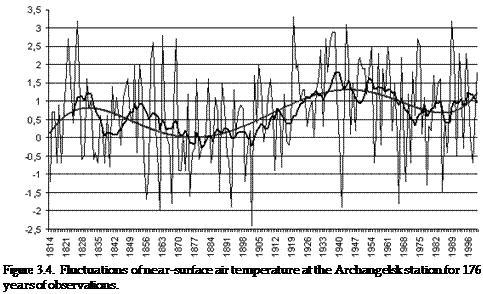
timescales of 4-5 years and 11-13 years. Such patterns of the air temperature variability with the same cycles are observed for the air temperature spectra across vast regions of Fennoscandia (Filatov, 1997). Smirnov et al. (1998) report that 3-4-year variations are evident almost throughout the entire North Atlantic. Their mechanisms have not been described in sufficient detail. The same paper proves that the four-year cycle arises when fluctuations with a seven-year cycle interfere with shorter cycle fluctuations (e.g., biennial). We detected these fluctuations in the data on daily air temperature measurements within the White Sea basin (Figures 3.4-3.5), and in the data for long-term monitoring of the White Sea water temperature for more than 20 years (Figure 3.6).
The lowest sea surface temperature (SST) for all of the White Sea stations analyzed were recorded in the late 1970s, mid-1980s, and early 1990s, with the highest in 1989. The SST minimum occurred one year earlier in the southern part of the sea (Zhuzhmui station), on the Karelian coast and on the Zimniy coast (the Intsy station) (1978) than in the north of the central part. A possible reason is the
|
 |

 (b)
(b)
 (c)
(c)
Figure 3.3. Mean annual air temperature (oC) at the weather stations (a) Zasheyek, (b) Louhi, and (c) Kolezhma in the White Sea catchment.
following. In the 1960s and the first-half of the 1970s, the frequency of westerly finds, related to the NAO processes, decreased notably (Smirnova et al., 2001), causing a decline in atmospheric precipitation brought down from the Atlantic and in river runoff in the south of the White Sea watershed area. Stations situated in the north of the White Sea area (e.g., Chavanga station) are more exposed to a direct impact of cold water masses transported from the Barents Sea by the Deriugin Current.
  | |||
 |
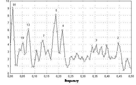 Figure 3.5. Frequency spectrum of near-surface air temperature at the Archangelsk station during 176 years of observations.
Joint analyses of water and air temperature data on the White and Barents Seas (Belkin et al., 1998) along the Kola meridian have revealed a good deal of similarity both in their variability and the duration, amplitude, and phase of their cycles.
It is obvious that the observed changes in the surface water temperature at the
|
 |
 Table 3.4. Statistical characteristics of the surface water temperature (mean daily data) at the Solovki, Gridino, Zhuzhmui, Intsy, Kandalaksha, Chavanga, Mudjug, Zhizhtin, and Unskiy lighthouse stations.
Unskiy Parameter Solovki Gridino Zhuzhmui Intsy Kandalaksha Chavanga Mudjug Zhizhtin lighthouse
| Mean | 3.73 | 3.32 | 3.34 | 3.08 | 3.87 | 3.53 | 5.24 | 2.84 | 4.19 |
| Medium | 0.43 | 0.30 | 0.70 | 0.48 | 1.10 | 1.30 | 0.08 | 0.88 | 0.83 |
| Standard | 5.89 | 5.48 | 5.35 | 5.03 | 5.05 | 4.54 | 6.99 | 4.72 | 6.31 |
| deviation | |||||||||
| Variance | 34.67 | 29.98 | 28.60 | 25.31 | 25.54 | 20.61 | 48.88 | 22.26 | 39.76 |
| Kurtosis | -0.98 | -0.89 | -1.22 | -1.16 | -0.61 | -0.51 | -0.86 | -1.25 | -0.98 |
| Asymmetry | 0.72 | 0.76 | 0.59 | 0.62 | 0.88 | 0.84 | 0.82 | 0.55 | 0.70 |
| Minimum | -1.95 | -2.00 | -1.90 | -1.60 | -1.78 | -1.95 | -1.70 | -2.00 | -1.90 |
| Maximum | 18.28 | 17.90 | 16.40 | 16.55 | 18.68 | 19.10 | 24.50 | 15.70 | 21.60 |
northern White Sea stations (Table 3.4), namely, the Chavanga and Kandalaksha are in good conformity with the changes in the water temperature reported from the Barents Sea, but with a one-year time lag (Figures 3.7 and 3.8).
The White Sea watershed area is in a zone of excessive humidity. The factors significantly affecting the distribution of atmospheric precipitation are the morpho- metric features of the terrain and characteristics of the substratum. Both are highly consequential in terms of the actual spatial distribution of soil moisture. Precipita- tion notably decreases near the large water bodies and the total annual atmospheric
 |
 Figure 3.7. Variability of the mean annual water surface temperature in both the Barents Sea (200 m off the Kola meridian) and the White Sea (Chavanga, Kandalaksha, Intsy, and Zhuzhmui stations).
precipitation over the Karelian coast of the White Sea is the lowest (500-550 mm). The relatively flat coast of the central and northern White Sea is covered by extensive areas of mires, with no obstructions to winds as far as the uplands of the western coast. Due to these topographic characteristics, the impact of the White Sea in the area results in milder mean annual air temperatures and in a regional atmospheric precipitation minimum along the northern coast. During the summer period, the White Sea is colder than the land, so the air from the sea warms up over land both retaining its own moisture, and also absorbing it from the land (Romanov, 1961). The annual atmospheric precipitation to the south of 64oN is over 500 mm, further to the north it is under 500 mm, being 400 mm on the coast of the Barents Sea (Table 3.5). This happens because pathways of baric depression movements in the summer are found further south than they are in winter due to shifts of atmospheric action centers. Annual precipitation is the lowest in the center of the basin and the Voronka (below 300 mm) and is highest over the relatively warm southern part of the sea (i.e., over Dvinskiy and Onezhskiy Bays (500-600 mm)).
The precipitation is unevenly distributed throughout the year (Table 3.6). It is most abundant from June through October (280-320 mm), accounting for about 60% of the annual total. The months with the lowest atmospheric precipitation are February and March (17-26 mm month-1). Of the total annual atmospheric precipitation in the area, 71-75% falls in the warm period of the year (April- October). Average annual precipitation comprises 55-65% of liquid, 20-30% of solid, and 13-18% of mixed atmospheric precipitation.
|
 | |||
 |


 Figure 3.8. Multi-year series of annual atmospheric precipitation at (a) Kolezhma, (b) Zasheyek, and (c) Louhi stations.
Table 3.5. Mean annual and maximum daily rates of precipitation at some stations in the White Sea.
From Climate of the USSR ... (1968).
Station name Total (mm) Daily maximum (mm)
| Kanin Nos | 9.0 | |
| Sosnovets island | - | |
| Mezent | 18.0 | |
| Louhi | 23.6 | |
| Kemt 425 - | ||
| Archangelsk | 14.8 | |
| Onega | 28.0 |
Table 3.6. Mean monthly precipitation over the west coast of the White Sea (mm).


 Month Jan Feb Mar Apr May Jun Jul Aug Sep Oct Nov Dec Annual Precipitation 35 19 29 34 42 50 65 69 66 62 43 43 567
Thus, the average precipitation increases in the north-to-south and east-to-west directions. Heavy precipitation can reduce the salinity of surface water layers. Significant inter-annual variations in atmospheric precipitation are reported. For instance, precipitation over Kolezhma in May 1978 was 1.6 mm with the norm for the month being 36 mm. At the Louhi station, 138 mm of precipitation was recorded in August 1981, with the norm being 76 mm. Maximum daily precipitation may be quite significant (e.g., 60 mm of rain fell on Louhi during a single day in August 1959 and 60 mm fell on Kolezhma during 3 hours in July 1989).
The regional precipitation patterns are classified in four main categories (Schwer, 1976): non-continental (maritime), semi-continental, continental, and extremely continental. These are identified depending on the ratio in the amount of atmospheric precipitation during spring/summer (March through August) and autumn/winter (September through February) seasons. More abundant atmospheric precipitation in the autumn/winter season is characteristic of the maritime climate. The annual pattern of atmospheric precipitation at the Kanin Nos, Cape Konushin, Mezen, Archangelsk, and Onega stations (the atmospheric precipitation ratio of the two periods is below 1.0) is typical of maritime locations. Stations on the west coast of the White Sea (Kolezhma, Kem-Port, and Louhi stations) and the Sosnovets station show slight prevalence of total precipitation in the spring/summer season, which is characteristic of the semi-continental, transitional climate.
Relative air humidity over the White Sea area is a fairly stable meteorological characteristic, with high values during the entire year: from monthly means of 67-69% in May-June to 88-89% in November-December. The annual dynamics of the relative air humidity according to the data from the stations located close to the White Sea is shown in Figure 3.9.
|
 %
%
Fog represents yet another phenomenon not uncommon for the White Sea. Fog is formed chiefly due to changes in air temperature and humidity. The annually averaged number of foggy days on the west coast of the White Sea is 32-34. In some years, the number of foggy days may reach 54-60. Fog events are least frequent from May through July (1-2 days a month), and they are most frequent in August and October (3-5 days), which is due to the activation of cyclonic activity and transport of Atlantic air masses over the White Sea. This results in the formation of advection fog. The frequency of fog occurrences during winter is also quite high: typically three days a month, which is due to a higher probability of radiation fogs caused by air cooling over ice-covered bays.
Drifting snow is a typical feature of climatic conditions in the White Sea Basin. Two types of drifting snow are distinguished: falling/blowing snow and low blowing snow. Since it is not always possible to determine the exact type of drifting snow, all types are summed up when calculating the number of days with this phenomenon. Drifting snow may take place in the region from September through June, with an average of between 30 and 40 days per year. Drifting snow grows more frequently in the middle of the winter season, peaking in January due to high wind activity, the greatest number of days with solid precipitation among all months and the driest snow. The number of drifting snow days may then reach 10-15, or even 20-25 per month in some years. By April, the frequency of drifting snow drops significantly to 3-4 days per month. Years with drifting snow in June are very rare on the Karelian coast of the White Sea. However, this phenomenon has been recorded at least once in the observations from the Louhi and Kem-Port stations over the study period.
3.2 CLIMATIC SCENARIOS AND ESTIMATION OF RIVER RUNOFF CHANGES
3.2.1 Climatic scenarios
The statistical analysis of the meteorological and water balance data from north- western Russia undertaken for the period 1880-1999, and numerical simulations
carried out using the Max-Planck Institute for Meteorology model called ECHAM4/ OPYC3 (Roeckner et al., 1999), shows changes in the climate and hydrological regime in the White Sea Basin (Filatov et al., 2002). Possible climate and water balance changes in the studied region were assessed for the period 2000-2050 (via two IPCC scenarios with doubling greenhouse gases and two options: with and without aerosols).
The analysis of general tendencies in the long-term (decadal) meteorological and hydrological time series in the White Sea catchment (WSC) points to the presence of positive linear trends in annual air temperature (T ), precipitation (P), total evapora- tion (E), and river runoff (R) (see Figures 3.3, 3.8, and 3.11).
Simulated data (on about 40 parameters, including air temperature, total pre- cipitation, and others) were obtained for the period 1960-1999 and for two scenarios for the period 2000-2050. The option of doubling of greenhouse gases only, and the option of doubling of greenhouse gases while taking into account the effect of atmospheric aerosols, are coined here as G and GA scenarios, respectively.
To estimate the conformity between the monthly averaged observed annual air temperature and precipitation and the simulation data obtained for separate weather within the White Sea Basin, these data were compared with those in the correspond- ing grid points, situated nearby. Analysis of the superposed observed and model data for weather stations showed a good correspondence in monthly and annual air temperature. However, it is not the case for monthly precipitation data (Bobylev et al., 2003). The climate in the WSC will become more continental. Figure 3.10 illustrates the present and anticipated (under the GA and G scenarios) air tempera- ture spatial distribution over the region.
The regional climate model simulations indicate a strong tendency for an increase in the annual air temperature and precipitation in the years to come. The mean annual precipitation will increase by about 30-50 mm in the case of both scenarios. The mean annual air temperature for the next 50-year period will rise from 1.8oC to 2.5-2.7oC (Figure 3.11). As shown by Filatov et al. (2003), at
|
-1
-1
+1 +1 +

| |
|
| |
+2 +
+2 -1 +3 + 2
+1 +
| |
| |
| |
| |
+4 +3 2
+5 +4 3
Figure 3.10. Spatial distribution of mean air temperature in the White Sea region (1) observed from 1950-1999, and simulated future options according to the (2) GA and (3) G scenarios.
850
 (a)
(a)

 550
550
(b)
|
 400
400
 350
350
1840 1860 1880 1900 1920 1940 1960 1980 2000 2020 2040
(c)
Figure 3.11. Observed (up to the year 2000) and modeled time series of the water balance elements (modeled for the GA and G scenarios): (a) precipitation, (b) evaporation, and (c) river runoff for north-western Russia. All values are 15-year moving averages.
present the spring air temperature over the territory has a most pronounced increas- ing trend. In future, in accordance with the GA and G scenarios the winter season (December-February) will have the largest temperature increase across the entire area.
Coupling of the GCM and regional model (Salo, 2003) allowed estimation of the anticipated changes in precipitation, total evaporation, and river runoff for the territory of Karelia during the period 2000-2050. This estimation shows that in the
Table 3.7. Observed and modeled changes in the mean annual air temperature and water
balance elements for the territory of Karelia.
 Period
| ||||
| Variable | 1950-1999 | 2000-2049 | Scenario option | Changes (%) |
| Air temperature (oC) | 1.8 ± 0.2 | 2.7 ± 0.3 | GA | |
| 2.5 ± 0.1 | G | + 38-50 | ||
| Precipitation (mm) 750 ± 25 763 ± 17 CA 767 ± 12 G + 1-2 | ||||
| Evaporation (mm) | 413 ± 13 | 466 ± 17 | CA | |
| 455 ± 9 | G + 10-13 | |||
| River runoff (mm) | 322 ± 14 | 297 ± 7 | CA | |
| 312 ± 7 | G -3-8 |
case of both scenarios all water balance parameters, excluding river runoff, will increase (Table 3.7).
3.2.2 Estimation of change in river runoff to the White Sea
The total area of the White Sea Basin watershed is 718,000 km2. The coefficient of the relative watershed, determined as the ratio of the total sea area to the watershed area is 1 : 8.3. According to Ivanov (1976), it is the greatest coefficient of all the marginal seas of the Arctic Ocean. This coefficient is indicative of the potentially significant role of the watershed area in the development of hydrological and chemical-biological processes in the White Sea. The mean annual influx of river water to the White Sea is 231 km3, including 108 km3(46.8%) coming from the Severnaya Dvina watershed (Table 3.8).
River watershed areas, located in similar physico-geographical conditions, are characterized by both (i) a synchronism of time series reflecting the annual water discharge and (ii) high correlation coefficients (r). The analyses of water discharge from rivers flowing into the White Sea from the Kola Peninsula (Ponoi, Varzuga, and Umba Rivers) indicate that the correlation of discharge series is in the range 0.83-0.87. In the case of the western coast of the White Sea (Kem, Nizhnii Vyg, and Kovda Rivers) the correlation coefficients are much lower due to the fact that the river discharge there is regulated by numerous hydroelectric power plants. The time series of the annual runoff of the largest tributary of the White Sea, viz. the Severnaya Dvina River, is strongly correlated with time series for the Onega and Mezen Rivers (r "' 0.77 and 0.71, respectively) and weakly correlated with the runoff from significantly smaller watersheds (e.g., that of the Kola Peninsula). This result points to both a significant heterogeneity in river runoff in various parts of the WSC and a strong influence of seasonal and interannual industrial impact related to the hydropower runoff. The negative trend observed during the period of investigations relates to the runoffs of the Severnaya Dvina, Onega, and Mezen Rivers, while an
|
Table 3.8. The mean annual water income from the WSC.
From Ivanov (1999).
Surface of watershed area River runoff


Catchment (km2) (%) (km3) (%)
| Kola Peninsula | 66,900 | 9.3 | 25.8 | 11.2 |
| Karelia | 101,000 | 14.1 | 32.8 | 14.3 |
| Arkhangelsk region (excluding the | 193,000 | 26.9 | 64.0 | 27.7 |
| catchment of the Severnaya Dvina River) Severnaya Dvina River | 357,000 | 49.7 | 46.8 | |
| Total | 718,000 | 100.0 | 231 | 100.0 |
increase is reported for the largest western tributaries of the White Sea (Kovda, Kem, and Nizhnii Vyg Rivers). The river runoff from the Kola Peninsula watershed exhibits only a weakly positive trend.
The time series for the river runoff of the seven largest rivers (Severnaya Dvina, Mezen, Onega, Kem, Nizhnii Vyg, Kovda, and Ponoi) along with the contribution of their watersheds to the total WSC were used to calculate the average weighted module of annual discharge for the entire White Sea Basin (Mws).
Using the available data, we calculated a continuous time series of the total
annual river runoff into the White Sea during 1882-1988. The average Mws discharge for a 107-year period is 241 km3, which only slightly (by 4.5%) differs from the normal discharge into the White Sea, viz. 231 km3(see Chapter 2 and Figure 3.12).
The above-mentioned runoff time series is characterized by a significant secular variability. For the entire period of observations the standard deviation for runoff is
40.2 km3. The obtained parameterization for the revealed linear trend allows predic-
tion of a general decrease in the runoff into the White Sea during the period under consideration.
During 1882-1988, the rate of decrease in the river runoff into the White Sea was
29.1 km3per 100 years. The general trend in the decrease of freshwater runoff should lead to a certain increase in water salinity, which was supported by both a suite of independent direct measurements (Smirnova et al., 2001), as well as by numerical simulation data (Neelov et al., 1996; see also Chapter 8).
According to the scenarios used in ECHAM4/OPYC3 modeling, the annual atmospheric precipitation in the region will grow by 5-10% with regard to the present-day values, while the mean annual total evaporation will increase by 25-30% (Table 3.8). As result, the total river runoff to the White Sea may decrease by 10-15% (from 322 mm presently to 297-312 mm in the future). Thus, the mean annual volume of river inflow to the White Sea may reduce. The mean annual volume of river runoff to the White Sea decreased from 228 to 195-205 km3during the 20th century, according to the calculations performed. In this case,

changes in the hydrological regime do not appear to be significant but, nonetheless, it will require some new approaches to the management of several basic branches of the regional economy (hydro-engineering construction, hydroelectric power industry, shipping, etc.).
Date: 2016-03-03; view: 774
| <== previous page | | | next page ==> |
| White Sea watershed hydrology and anthropogenic impact 4 page | | | Oceanographic regime 1 page |