CATEGORIES:
BiologyChemistryConstructionCultureEcologyEconomyElectronicsFinanceGeographyHistoryInformaticsLawMathematicsMechanicsMedicineOtherPedagogyPhilosophyPhysicsPolicyPsychologySociologySportTourism
Agriculture and fishingAlaska Alaska ( Alaska was purchased from Russia on March 30, 1867, for $7.2 million ($120 million adjusted for inflation) at approximately two cents per acre ($4.74/km²). The land went through several administrative changes before becoming an organized (or incorporated) territory on May 11, 1912, and the 49th state of the U.S. on January 3, 1959.[6] The name "Alaska" (Аляска) was already introduced in the Russian colonial period, when it was used only for the peninsula and is derived from the Aleut alaxsxaq, meaning "the mainland" or, more literally, "the object towards which the action of the sea is directed".[7] It is also known as Alyeska, the "great land", an Aleut word derived from the same root. Geography Alaska has a longer coastline than all the other U.S. states combined.[8] It is the only non-contiguous U.S. state on continental North America; about 500 miles (800 km) of British Columbia (Canada) separates Alaska fromWashington state. Alaska is thus an exclave of the United States, possibly the largest exclave in the world. It is technically part of the continental U.S., but is often not included in colloquial use; Alaska is not part of the contiguous U.S., often called "the Lower 48".[9] The capital city, Juneau, is situated on the mainland of the North American continent, but is not connected by road to the rest of the North American highway system. The state is bordered by the Yukon Territory and British Columbia in Canada, to the east, the Gulf of Alaska and the Pacific Ocean to the south, the Bering Sea, Bering Strait, and Chukchi Sea to the west and the Arctic Ocean to the north. Alaska's territorial waters touch Russia's territorial waters in the Bering Strait, as the Russian Big Diomede Island and Alaskan Little Diomede Island are only 3 miles (4.8 km) apart. With the extension of the Aleutian Islands into the eastern hemisphere, it is technically both the westernmost and easternmost state in the United States, as well as also being the northernmost.
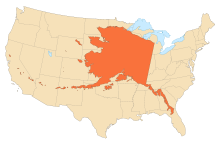
Alaska's size compared with the 48 contiguous states. Alaska is the largest state in the United States in land area at 586,412 square miles (1,518,800 km2), over twice the size of Texas, the next largest state. Alaska is larger than all but 18 sovereign countries. Counting territorial waters, Alaska is larger than the combined area of the next three largest states: Texas, California, and Montana. It is also larger than the combined area of the 22 smallest U.S. states. Regions There are no officially defined borders demarcating the various regions of Alaska, but there are six widely accepted regions: South Central The most populous region of Alaska, containing Anchorage, the Matanuska-Susitna Valley and the Kenai Peninsula. Rural, mostly unpopulated areas south of the Alaska Range and west of the Wrangell Mountains also fall within the definition of Southcentral, as well as the Prince William Sound area and the communities of Cordova and Valdez. Southeast Also referred to as the Panhandle or Inside Passage, this is the region of Alaska closest to the rest of the United States. As such, this was where most of the initial non-indigenous settlement occurred in the years following theAlaska Purchase. The region is dominated by the Alexander Archipelago as well as the Tongass National Forest, the largest national forest in the United States. It contains the state capital, Juneau, the former capital, Sitka, andKetchikan, at one time Alaska's largest city.[10] The Alaska Marine Highway provides a vital surface transportation link throughout the area, as only three communities (Haines, Hyder and Skagway) enjoy direct connections to the contiguous North American road system. Interior The largest region of Alaska, much of it uninhabited wilderness. Fairbanks is the only community of any significant size. Small towns and Native villages are scattered throughout, mostly along the highway and river systems. Denali National Park and Preserve is located here, home to Mount McKinley (also widely known by its local name of Denali), the highest point in North America. Southwest. A sparsely inhabited region stretching some 500 miles (800 km) inland from the Bering Sea. Most of the population lives along the coast. Kodiak Island is also located in Southwest. The massive Yukon–Kuskokwim Delta, one of the largest river deltas in the world, is here. Portions of the Alaska Peninsula are considered part of Southwest, with the remaining portions included with the Aleutian Islands (see below). North Slope The North Slope is mostly tundra peppered with small villages. The area is known for its massive reserves of crude oil, and contains both the National Petroleum Reserve–Alaska and thePrudhoe Bay Oil Field.[11] Barrow, the northernmost city in the United States, is located here. The Northwest Arctic area, anchored by Kotzebue and also containing the Kobuk River valley, is often regarded as being part of this region. However, the respective Inupiat of the North Slope and of the Northwest Arctic seldom think of themselves as one. Aleutian Islands More than 300 small, volcanic islands make up this chain, which stretches over 1,200 miles (1,900 km) into the Pacific Ocean. The International Date Line was drawn west of 180° to keep the whole state, and thus the entire North American continent, within the same legal day. However, because some of these islands fall in the Eastern Hemisphere, this makes Alaska the northernmost, easternmost and westernmost state in the union, with the southernmost state being Hawaii. Two of the islands, Attu and Kiska, were occupied by Japanese forces during World War II. Natural features With its myriad islands, Alaska has nearly 34,000 miles (54,720 km) of tidal shoreline. The Aleutian Islands chain extends west from the southern tip of the Alaska Peninsula. Many active volcanoes are found in the Aleutians and in coastal regions. Unimak Island, for example, is home to Mount Shishaldin, which is an occasionally smoldering volcano that rises to 10,000 feet (3,048 m) above the North Pacific. It is the most perfect volcanic cone on Earth, even more symmetrical than Japan's Mount Fuji. The chain of volcanoes extends toMount Spurr, west of Anchorage on the mainland. Geologists have identified Alaska as part of Wrangellia, a large region consisting of multiple states and Canadian provinces in thePacific Northwest which is actively undergoing continent building. One of the world's largest tides occurs in Turnagain Arm, just south of Anchorage – tidal differences can be more than 35 feet (10.7 m). (Many sources say Turnagain has the second-greatest tides in North America, but several areas in Canada have larger tides.) Alaska has more than three million lakes.[13][14] Marshlands and wetland permafrost cover 188,320 square miles (487,747 km2) (mostly in northern, western and southwest flatlands). Glacier ice covers some 16,000 square miles (41,440 km2) of land and 1,200 square miles (3,110 km2) of tidal zone. The Bering Glacier complex near the southeastern border with Yukon covers 2,250 square miles (5,827 km2) alone. With over 100,000, Alaska has half of the world's glaciers. Land ownership According to an October 1998 report by the United States Bureau of Land Management, approximately 65% of Alaska is owned and managed by the U.S. federal government as public lands, including a multitude of national forests, national parks, and national wildlife refuges. Of these, the Bureau of Land Management manages 87 million acres (35 million hectares), or 23.8% of the state. The Arctic National Wildlife Refuge is managed by the United States Fish and Wildlife Service. It is the world's largest wildlife refuge, comprising 16 million acres (6.5 million hectares). Of the remaining land area, the state of Alaska owns 101 million acres (41 million hectares); its entitlement under the Alaska Statehood Act. A portion of that acreage is occasionally ceded to organized boroughs, under the statutory provisions pertaining to newly formed boroughs. Smaller portions are set aside for rural subdivisions and other homesteading-related opportunities, though these are infrequently popular due to the often remote and roadless locations. The University of Alaska, as a land grant university, also owns substantial acreage which it manages independently. Another 44 million acres (18 million hectares) are owned by 12 regional, and scores of local, Native corporations created under the Alaska Native Claims Settlement Act. Regional Native corporation Doyon, Limited often promotes itself as the largest private landowner in Alaska in advertisements and other communications. Provisions of ANCSA allowing the corporations' land holdings to be sold on the open market starting in 1991 were repealed before they could take effect. Effectively, the corporations hold title (including subsurface title in many cases, a privilege denied to individual Alaskans) but cannot sell the land. Individual Native allotments can be and are sold on the open market, however. Various private interests own the remaining land, totaling about one percent of the state. Alaska is, by a large margin, the state with the smallest percentage of private land ownership when Native corporation holdings are excluded. Climate The climate in Juneau and the southeast panhandle is a mid-latitude oceanic climate (Köppen climate classification Cfb) in the southern sections and a subarctic oceanic climate (Köppen Cfc) in the northern parts. On an annual basis, the panhandle is both the wettest and warmest part of Alaska with milder temperatures in the winter and high precipitation throughout the year. Juneau averages over 50 inches (1,270 mm) of precipitation a year. This is also the only region in Alaska in which the average daytime high temperature is above freezing during the winter months. The climate of Anchorage and south central Alaska is mild by Alaskan standards due to the region's proximity to the seacoast. While the area gets less rain than southeast Alaska, it gets more snow, and days tend to be clearer. On average, Anchorage receives 16 inches (406 mm) of precipitation a year, with around 75 inches (191 cm) of snow, although there are areas in the south central which receive far more snow. It is a subarctic climate (Köppen Dfc) due to its brief, cool summers. The climate of Western Alaska is determined in large part by the Bering Sea and the Gulf of Alaska. It is a subarctic oceanic climate in the southwest and a continental subarctic climate farther north. The temperature is somewhat moderate considering how far north the area is. This region has a tremendous amount of variety in precipitation. An area stretching from the northern side of the Seward Peninsula to the Kobuk River valley is technically a desert, with portions receiving less than 10 inches (254 mm) of precipitation annually. On the other extreme, some locations between Dillingham and Bethel average around 100 inches (2,540 mm) of precipitation.[16] The climate of the interior of Alaska is subarctic. Some of the highest and lowest temperatures in Alaska occur around the area near Fairbanks. The summers may have temperatures reaching into the 90s °F (the low to mid 30s °C), while in the winter, the temperature can fall below −60 °F (−51.1 °C). Precipitation is sparse in the Interior, often less than 10 inches (254 mm) a year, but what precipitation falls in the winter tends to stay the entire winter. The highest and lowest recorded temperatures in Alaska are both in the Interior. The highest is 100 °F (37.8 °C) in Fort Yukon (which is just 8 miles or 13 kilometers inside the arctic circle) on June 27, 1915,[17][18] making Alaska tied with Hawaii as the state with the lowest high temperature in the United States.[19][20] The lowest official Alaska temperature is−80 °F (−62.2 °C) in Prospect Creek on January 23, 1971,[17][18] one degree above the lowest temperature recorded in continental North America (in Snag, Yukon, Canada).[21] The climate in the extreme north of Alaska is Arctic (Köppen ET) with long, very cold winters and short, cool summers. Even in July, the average low temperature in Barrow is 34 °F(1.1 °C).[22] Precipitation is light in this part of Alaska, with many places averaging less than 10 inches (254 mm) per year, mostly as snow which stays on the ground almost the entire year. History Alaska natives Numerous indigenous people occupied Alaska for thousands of years before the arrival of European peoples to the area. The Tlingit people developed a matriarchal society in what is today Southeast Alaska, along with parts of British Columbia and the Yukon. Also in Southeast were the Haida, now well known for their unique arts, and the Tsimshian people, whose population were decimated by a smallpox epidemic in the 1860s. The Aleutian Islands are still home to the Aleut people's seafaring society, although they were among the first native Alaskans to be exploited by Russians. Western and Southwestern Alaska are home to the Yup'ik, while their cousins the Alutiiq lived in what is now Southcentral Alaska. The Gwich’in people of the northern Interior region are primarily known today for their dependence on the caribou within the much-contested Arctic National Wildlife Refuge. The North Slope and Little Diomede Island are occupied by the widespread Inuit people. Colonization Some researchers believe that the first Russian settlement in Alaska was established in 17th century.[23] According to this hypothesis, in 1648 several koches of Semyon Dezhnyov's expedition were thrown to Alaska by storm and founded this settlement. This hypothesis is based on the message of Chukchi geographer Nikolai Daurkin who had visited Alaska in 1764–1765 and reported about a village on theKheuveren river, populated by "bearded men" who "pray to the icons". Some modern researchers associate Kheuveren with Koyuk River.[24]
It is usually assumed that the first European boat to reach Alaska was the St. Gabriel under the authority of the surveyor M. S. Gvozdev and assistant navigator I. Fyodorov on August 21, 1732 during expedition of Siberian cossak A. F. Shestakov adb Belorussian explorer D. I. Pavlutsky (1729—1735)[25] Another European contact with Alaska occurred in 1741, when Vitus Bering led an expedition for the Russian Navy aboard the St. Peter. After his crew returned to Russia with sea otter pelts judged to be the finest fur in the world, small associations of fur traders began to sail from the shores of Siberia towards the Aleutian islands. The first permanent European settlement was founded in 1784. Between 1774 and 1800 Spain sent several expeditions to Alaska in order to assert its claim over the Pacific Northwest. In 1789 a Spanish settlement and fort were built in Nootka Sound. These expeditions gave names to places such as Valdez, Bucareli Sound, and Cordova. Later, the Russian-American Company carried out an expanded colonization program during the early-to-mid-19th century. Sitka, renamed New Archangel from 1804 to 1867, on Baranof Island in the Alexander Archipelago in what is now Southeast Alaska, became the capital of Russian America and remained the capital after the colony was transferred to the United States. The Russians never fully colonized Alaska, and the colony was never very profitable. William H. Seward, the United States Secretary of State, negotiated the Alaska Purchase (also known as Seward's Folly) with the Russians in 1867 for $7.2 million. Alaska was loosely governed by the military initially, and was administered as a district starting in 1884, with a governor appointed by the president of the United States, as well as a district court headquartered in Sitka.
Miners and prospectors climb theChilkoot Trail during the Klondike Gold Rush. For most of Alaska's first decade under the American flag, Sitka was the only community inhabited by American settlers. They organized a "provisional city government," which was Alaska's first city government, but not in a legal sense. Legislation allowing Alaskan communities to legally incorporate as cities did not come about until 1900, and home rule for cities was extremely limited or unavailable until statehood took effect. U.S. Territory Starting in the 1890s and stretching in some places to the early 1910s, gold rushes in Alaska and the nearby Yukon Territory brought thousands of miners and settlers to Alaska. Alaska was officially incorporated as an organized territory in 1912. Alaska's capital, which had been in Sitka until 1906, was moved north to Juneau, and began to take shape with the construction of the Alaska Governor's Mansion that same year. During World War II, the Aleutian Islands Campaign focused on the three outer Aleutian Islands – Attu, Agattu and Kiska[26] – that were invaded by Japanese troops and occupied between June 1942 and August 1943. Unalaska/Dutch Harbor became a significant base for the U.S. Army Air Corps and Navy submariners. The U.S. Lend-Lease program involved the flying of American warplanes through Canada to Fairbanks and thence Nome; Soviet pilots took possession of these aircraft, ferrying them to fight the German invasion of the Soviet Union. The construction of military bases contributed to the population growth of some Alaskan cities. Statehood Statehood for Alaska was an important cause of James Wickersham early in his tenure as a congressional delegate. Decades later, the statehood movement gained its first real momentum following a territorial referendum in 1946. The Alaska Statehood Committee and Alaska's Constitutional Convention would soon follow. Statehood supporters also found themselves fighting major battles against political foes, mostly in the U.S. Congress but also within Alaska. Statehood was approved by Congress on July 7, 1958. Alaska was officially proclaimed a state on January 3, 1959. On April 27, 1964, the massive "Good Friday Earthquake" killed 133 people and destroyed several villages and portions of large coastal communities, mainly by the resultant tsunamisand landslides. It was the third most powerful earthquake in the recorded history of the world, with a moment magnitude of 9.2. It was over one thousand times more powerful than the 1989 San Francisco earthquake. The time of day (5:36 pm), time of year and location of the epicenter were all cited as factors in potentially sparing thousands of lives, particularly in Anchorage. The 1968 discovery of oil at Prudhoe Bay and the 1977 completion of the Trans-Alaska Pipeline led to an oil boom. Royalty revenues from oil have funded large state budgets from 1980 onward. That same year, not coincidentally, Alaska repealed its state income tax. In 1989, the Exxon Valdez hit a reef in the Prince William Sound, spilling over 11,000,000 US gallons (42,000 m3) of crude oil over 1,100 miles (1,600 km) of coastline. Today, the battle between philosophies of development and conservation is seen in the contentious debate over oil drilling in the Arctic National Wildlife Refuge. Demographics Main article: Demographics of Alaska
The United States Census Bureau estimates that the population of Alaska was 722,718 on July 1, 2011, a 1.76% increase since the 2010 United States Census.[4] In 2010, Alaska ranked as the 47th state by population, ahead of North Dakota, Vermont, and Wyoming (and Washington, D.C.)[28] Alaska is the least densely populated state, and one of the most sparsely populated areas in the world, at 1.2 inhabitants per square mile (0.46 /km2), with the next state, Wyoming, at 5.8 inhabitants per square mile (2.2 /km2).[29] Alaska is the largest U.S. state by area, and the tenth wealthiest (per capita income).[30] As of April 2012, the state's unemployment rate was 6.9%.[31] Race and ancestry According to the 2010 U.S. Census, Alaska had a population of 710,231. In terms of race and ethnicity, the state was 66.7% White (64.1% Non-Hispanic White Alone), 19.1% American Indian and Alaska Native, 7.1% Asian, 4.7% Black or African American, 1.6% Native Hawaiian and Other Pacific Islander, 1.6% from Some Other Race, and 7.3% from Two or More Races. Hispanics or Latinos of any race made up 5.5% of the population.[32] In 1960, the Census Bureau reported Alaska's population as 77.2% White, 3% Black, and 18.8% American Indian and Alaska Native.[33] As of 2011, 50.7% of Alaska's population younger than age 1 were minorities.[34] Languages According to the 2005–2007 American Community Survey, 84.7% of people over the age of five speak only English at home. About 3.5% speak Spanish at home. About 2.2% speak another Indo-European language at home and about 4.3% speak an Asian language at home. And about 5.3% speak other languages at home.[35] A total of 5.2% of Alaskans speak one of the state's 22 indigenous languages, known locally as "native languages". These languages belong to two major language families:Eskimo–Aleut and Na-Dene. As the homeland of these two major language families of North America, Alaska has been described as the crossroads of the continent, providing evidence for the recent settlement of North America by way of the Bering land bridge. Religion Alaska has been identified, along with Pacific Northwest states Washington and Oregon, as being the least religious in the U.S.[36][37] According to statistics collected by the Association of Religion Data Archives, about 39% of Alaska residents were members of religious congregations. Evangelical Protestants had 78,070 members, Roman Catholics had 54,359, and mainline Protestants had 37,156.[38] After Catholicism, the largest single denominations are The Church of Jesus Christ of Latter-day Saints with 30,169,[39] and Southern Baptists with 22,959. The large Eastern Orthodox (with 49 parishes and up to 50,000 followers)[40] population is a result of early Russian colonization and missionary work among Alaska Natives.[41] In 1795, the First Russian Orthodox Church was established in Kodiak. Intermarriage with Alaskan Natives helped the Russian immigrants integrate into society. As a result, an increasing number of Russian Orthodox churches[42] gradually became established within Alaska. Alaska also has the largest Quaker population (by percentage) of any state.[43] In 2009 there were 6,000 Jews in Alaska (for whom observance of the mitzvah may pose special problems).[44] Estimates for the number of Alaskan Muslims range from 2,000[45][46]to 5,000.[47] In 2010, the local Muslim community broke ground on the first mosque in the state.[48] Alaskan Hindus often share venues and celebrations with members of other religious communities including Sikhs and Jains.[49][50][51] Economy The 2007 gross state product was $44.9 billion, 45th in the nation. Its per capita personal income for 2007 was $40,042, ranking 15th in the nation. The oil and gas industry dominates the Alaskan economy, with more than 80% of the state's revenues derived from petroleum extraction. Alaska's main export product (excluding oil and natural gas) is seafood, primarily salmon, cod, Pollock and crab. Agriculture represents only a fraction of the Alaskan economy. Agricultural production is primarily for consumption within the state and includes nursery stock, dairy products, vegetables, and livestock. Manufacturing is limited, with most foodstuffs and general goods imported from elsewhere. Employment is primarily in government and industries such as natural resource extraction, shipping, and transportation. Military bases are a significant component of the economy in both Fairbanks and Anchorage. Federal subsidies are also an important part of the economy, allowing the state to keep taxes low. Its industrial outputs are crude petroleum, natural gas, coal, gold, precious metals, zinc and other mining, seafood processing, timber and wood products. There is also a growing service and tourism sector. Tourists have contributed to the economy by supporting local lodging. Largest employers According to the Alaska Department of Labor and Workforce Development, the following were the state's largest private sector employers in 2010:[52]
Energy Alaska has vast energy resources. Major oil and gas reserves are found in the Alaska North Slope (ANS) and Cook Inlet basins. According to the Energy Information Administration, Alaska ranks second in the nation in crude oil production. Prudhoe Bay on Alaska's North Slope is the highest yielding oil field in the United States and on North America, typically producing about 400,000 barrels per day (64,000 m3/d). The Trans-Alaska Pipeline can transport and pump up to 2.1 million barrels (330,000 m3) of crude oil per day, more than any other crude oil pipeline in the United States. Additionally, substantial coal deposits are found in Alaska's bituminous, sub-bituminous, and lignite coal basins. The United States Geological Survey estimates that there are 85.4 trillion cubic feet (2,420 km3) of undiscovered, technically recoverable gas from natural gas hydrates on the Alaskan North Slope.[53] Alaska also offers some of the highest hydroelectric power potential in the country from its numerous rivers. Large swaths of the Alaskan coastline offer wind and geothermal energy potential as well.[54] Alaska's economy depends heavily on increasingly expensive diesel fuel for heating, transportation, electric power and light. Though wind and hydroelectric power are abundant and underdeveloped, proposals for state-wide energy systems (e.g. with special low-cost electric interties) were judged uneconomical (at the time of the report, 2001) due to low (<$0.50/Gal) fuel prices, long distances and low population.[55] The cost of a US gallon of gas in urban Alaska today is usually $0.30–$0.60 higher than the national average; prices in rural areas are generally significantly higher but vary widely depending on transportation costs, seasonal usage peaks, nearby petroleum development infrastructure and many other factors. Alaska accounts for one-fifth (20 percent)[citation needed] of domestically produced United States oil production. Prudhoe Bay (North America's largest oil field) alone accounts for 8% of the U.S. domestic oil production. Permanent Fund The Alaska Permanent Fund is a constitutionally authorized appropriation of oil revenues, established by voters in 1976 to manage a surplus in state petroleum revenues from oil, largely in anticipation of same from the recently constructed Trans-Alaska Pipeline System. The fund was originally proposed by Governor Keith Miller on the eve of the 1969 Prudhoe Bay lease sale, out of fear that the legislature would spend the entire proceeds of the sale (which amounted to $900 million) at once, and was later championed by Governor Jay Hammond and Kenai state representative Hugh Malone. It has served as an attractive political prospect ever since, diverting revenues which would normally be deposited into the general fund. The Alaska Constitution was written so as to discourage dedicating state funds for a particular purpose. The Permanent Fund has become the rare exception to this, mostly due to the political climate of distrust existing during the time of its creation. From its initial principal of $734,000, the fund has grown to $40 billion as a result of oil royalties and capital investment programs.[56] Most if not all the principal is invested conservatively outside Alaska. This has led to frequent calls by Alaskan politicians for the Fund to make investments within Alaska, though such a stance has never really gained momentum. Starting in 1982, dividends from the fund's annual growth have been paid out each year to eligible Alaskans, ranging from an initial $1,000.00 in 1982 (equal to three years' payout, as the distribution of payments was held up in a lawsuit over the distribution scheme) to $3,269.00 in 2008 (which included a one-time $1,200.00 "Resource Rebate"). Every year, the state legislature takes out 8 percent from the earnings, puts 3 percent back into the principal for inflation proofing, and the remaining 5 percent is distributed to all qualifying Alaskans. To qualify for the Permanent Fund Dividend, one must have lived in the state for a minimum of 12 months, maintain constant residency subject to allowable absences,[57] and not be subject to court judgments or criminal convictions which fall under various disqualifying classifications or may subject the payment amount to civil garnishment. Cost of living The cost of goods in Alaska has long been higher than in the contiguous 48 states. This has changed for the most part in Anchorage and to a lesser extent in Fairbanks, where the cost of living has dropped somewhat in the past five years. Federal government employees, particularly United States Postal Service (USPS) workers and active-duty military members, receive a Cost of Living Allowance usually set at 25% of base pay because, while the cost of living has gone down, it is still one of the highest in the country. The introduction of big-box stores in Anchorage, Fairbanks, and Juneau also did much to lower prices. Wal-Mart opened their first Anchorage store in 1993, and debuted in Fairbanks in 2004. The company currently has locations covering most of the population centers of Alaska, including Juneau, Ketchikan and Kodiak. However, rural Alaska suffers from extremely high prices for food and consumer goods, compared to the rest of the country due to the relatively limited transportation infrastructure. Many rural residents come into these cities and purchase food and goods in bulk from warehouse clubs like Costco and Sam's Club. Some have embraced the free shipping offers[58] of some online retailers to purchase items much more cheaply than they could in their own communities, if they are available at all. Agriculture and fishing Due to the northern climate and short growing season, relatively little farming occurs in Alaska. Most farms are in either the Matanuska Valley, about 40 miles (64 km) northeast of Anchorage, or on the Kenai Peninsula, about 60 miles (97 km) southwest of Anchorage. The short 100-day growing season limits the crops that can be grown, but the long sunny summer days make for productive growing seasons. The primary crops are potatoes, carrots, lettuce, and cabbage. The Tanana Valley is another notable agricultural locus, especially Delta Junction area, about 100 miles (160 km) southeast of Fairbanks, with a sizable concentration of farms growing agronomic crops; these farms mostly lie north and east of Fort Greely. This area was largely set aside and developed under a state program spearheaded by Hammond during his second term as governor. Delta-area crops consist predominately of barley and hay. West of Fairbanks lies another concentration of small farms catering to restaurants, the hotel and tourist industry, andcommunity supported agriculture. Alaskan agriculture has experienced a surge in growth of market gardeners, small farms and farmers' markets in recent years, with the highest percentage increase (46%) in the nation in growth in farmers' markets in 2011, compared to 17% nationwide.[59] The peony industry has also taken off, as the growing season allows farmers to harvest during a gap in supply elsewhere in the world, thereby filling a niche in the flower market.[60] Alaska, with no counties, also lacks county fairs. However, a small assortment of state and local fairs (with the Alaska State Fair in Palmer the largest), are held mostly in the late summer. The fairs are mostly located in communities with historic or current agricultural activity, and feature local farmers exhibiting produce in addition to more high-profile commercial activities such as carnival rides, concerts and food. "Alaska Grown" is used as an agricultural slogan. Alaska has an abundance of seafood, with the primary fisheries in the Bering Sea and the North Pacific, and seafood is one of the few food items that is often cheaper within the state than outside it. Many Alaskans take advantage of salmon seasons to harvest portions of their household diet while fishing for subsistence, as well as sport. This includes fish taken by hook, net or wheel.[61] Hunting for subsistence, primarily caribou, moose, and Dall sheep is still common in the state, particularly in remote Bush communities. An example of a traditional native food is Akutaq, the Eskimo ice cream, which can consist of reindeer fat, seal oil, dried fish meat and local berries. Alaska's reindeer herding is concentrated on Seward Peninsula where wild caribou can be prevented from mingling and migrating with the domesticated reindeer.[62] Most food in Alaska is transported into the state from "Outside", and shipping costs make food in the cities relatively expensive. In rural areas, subsistence hunting and gathering is an essential activity because imported food is prohibitively expensive. The cost of importing food to villages begins at 7¢ per pound (15¢/kg) and rises rapidly to 50¢ per pound ($1.10/kg) or more. The cost of delivering a 1 US gallon (3.8 L) of milk is about $3.50 in many villages where per capita income can be $20,000 or less. Fuel cost can exceed $8.00 per gallon.[citation needed] Transportation Roads Alaska has few road connections compared to the rest of the U.S. The state's road system covers a relatively small area of the state, linking the central population centers and theAlaska Highway, the principal route out of the state through Canada. The state capital, Juneau, is not accessible by road, only a car ferry, which has spurred several debates over the decades about moving the capital to a city on the road system, or building a road connection from Haines. The western part of Alaska has no road system connecting the communities with the rest of Alaska. One unique feature of the Alaska Highway system is the Anton Anderson Memorial Tunnel, an active Alaska Railroad tunnel recently upgraded to provide a paved roadway link with the isolated community of Whittier on Prince William Sound to the Seward Highway about 50 miles (80 km) southeast of Anchorage at Portage. At 2.5 miles (4.0 km) the tunnel was the longest road tunnel in North America until 2007.[63] The tunnel is the longest combination road and rail tunnel in North America. Rail Built around 1915, the Alaska Railroad (ARR) played a key role in the development of Alaska through the 20th century. It links north Pacific shipping through providing critical infrastructure with tracks that run from Seward to Interior Alaska by way of South Central Alaska, passing through Anchorage, Eklutna, Wasilla, Talkeetna, Denali, and Fairbanks, with spurs to Whittier, Palmer and North Pole. The cities, towns, villages, and region served by ARR tracks are known statewide as "The Railbelt". In recent years, the ever-improving paved highway system began to eclipse the railroad's importance in Alaska's economy. The railroad, though famed for its summertime tour passenger service, played a vital role in Alaska's development, moving freight into Alaska while transporting natural resources southward (i.e., coal from the Usibelli coal mine near Healy to Seward and gravel from the Matanuska Valley to Anchorage). The Alaska Railroad was one of the last railroads in North America to use cabooses in regular service and still uses them on some gravel trains. It continues to offer one of the last flag stop routes in the country. A stretch of about 60 miles (100 km) of track along an area north of Talkeetna remains inaccessible by road; the railroad provides the only transportation to rural homes and cabins in the area; until construction of the Parks Highway in the 1970s, the railroad provided the only land access to most of the region along its entire route. In northern Southeast Alaska, the White Pass and Yukon Route also partly runs through the state from Skagway northwards into Canada (British Columbia and Yukon Territory), crossing the border at White Pass Summit. This line is now mainly used by tourists, often arriving by cruise liner at Skagway. It featured in the 1983 BBC television series Great Little Railways. The Alaska Rail network is not connected to Outside. In 2000, the U.S. Congress authorized $6 million to study the feasibility of a rail link between Alaska, Canada, and the lower 48.[64][65][66] Alaska Rail Marine provides car float service between Whittier and Seattle. Marine transport Many cities, towns and villages in the state do not have road or highway access; the only modes of access involve travel by air, river, or the sea. Alaska's well-developed state-owned ferry system (known as the Alaska Marine Highway) serves the cities of southeast, the Gulf Coast and the Alaska Peninsula. The ferries transport vehicles as well as passengers. The system also operates a ferry service from Bellingham, Washington and Prince Rupert, British Columbia in Canada through the Inside Passage to Skagway. The Inter-Island Ferry Authority also serves as an important marine link for many communities in the Prince of Wales Island region of Southeast and works in concert with the Alaska Marine Highway. In recent years, cruise lines have created a summertime tourism market, mainly connecting the Pacific Northwest to Southeast Alaska and, to a lesser degree, towns along Alaska's gulf coast. The population of Ketchikan may rise by over 10,000 people on many days during the summer, as up to four large cruise ships at a time can dock, debarking thousands of passengers. Air transport Cities not served by road, sea, or river can be reached only by air, foot, dogsled, or snowmachine accounting for Alaska's extremely well developed bush air services—an Alaskan novelty. Anchorage itself, and to a lesser extent Fairbanks, are served by many major airlines. Because of limited highway access, air travel remains the most efficient form of transportation in and out of the state. Anchorage recently completed extensive remodeling and construction at Ted Stevens Anchorage International Airport to help accommodate the upsurge in tourism (in 2000–2001, the latest year for which data is available, 2.4 million total arrivals to Alaska were counted, 1.7 million by air travel; 1.4 million were visitors).[67][68]
Regular flights to most villages and towns within the state that are commercially viable are challenging to provide, so they are heavily subsidized by the federal government through theEssential Air Service program. Alaska Airlines is the only major airline offering in-state travel with jet service (sometimes in combination cargo and passenger Boeing 737-400s) from Anchorage and Fairbanks to regional hubs like Bethel, Nome, Kotzebue, Dillingham, Kodiak, and other larger communities as well as to major Southeast and Alaska Peninsula communities. The bulk of remaining commercial flight offerings come from small regional commuter airlines such as Era Aviation, PenAir, and Frontier Flying Service. The smallest towns and villages must rely on scheduled or chartered bush flying services using general aviation aircraft such as the Cessna Caravan, the most popular aircraft in use in the state. Much of this service can be attributed to the Alaska bypass mail program which subsidizes bulk mail delivery to Alaskan rural communities. The program requires 70% of that subsidy to go to carriers who offer passenger service to the communities. Many communities have small air taxi services. These operations originated from the demand for customized transport to remote areas. Perhaps the most quintessentially Alaskan plane is the bush seaplane. The world's busiest seaplane base is Lake Hood, located next to Ted Stevens Anchorage International Airport, where flights bound for remote villages without an airstrip carry passengers, cargo, and many items from stores and warehouse clubs. Alaska has the highest number of pilots per capita of any U.S. state: out of the estimated 663,661 residents, 8,550 are pilots, or about one in 78.[69] Other transport Another Alaskan transportation method is the dogsled. In modern times (that is, any time after the mid-late 1920s), dog mushing is more of a sport than a true means of transportation. Various races are held around the state, but the best known is the Iditarod Trail Sled Dog Race, a 1150-mile (1850 km) trail from Anchorage to Nome (although the distance varies from year to year, the official distance is set at 1,049 miles (1,688 km)). The race commemorates the famous 1925 serum run to Nome in which mushers and dogs like Togo and Balto took much-needed medicine to the diphtheria-stricken community of Nome when all other means of transportation had failed. Mushers from all over the world come to Anchorage each March to compete for cash, prizes, and prestige. The "Serum Run" is another sled dog race that more accurately follows the route of the famous 1925 relay, leaving from the community of Nenana (southwest of Fairbanks) to Nome.[70] In areas not served by road or rail, primary transportation in summer is by all-terrain vehicle and in winter by snowmobile or "snow machine," as it is commonly referred to in Alaska. Data transport Alaska's internet and other data transport systems are provided largely through the two major telecommunications companies: GCI and Alaska Communications. GCI owns and operates what it calls the Alaska United Fiber Optic system[71] and as of late 2011 Alaska Communications advertised that it has "two fiber optic paths to the lower 48 and two more across Alaska.[72] In January 2011, it was reported that a $1 billion project to run connect Asia and rural Alaska was being planned, aided in part by $350 million in stimulus from the federal government.[73] Date: 2015-12-18; view: 513
|
 i/əˈlæskə/) is a state in the United States, situated in the northwest extremity of the North American continent, with the international boundary with Canada to the east, the Arctic Ocean to the north, and the Pacific Ocean to the west and south, with Russia further west across the Bering Strait. Alaska is the largest state in theUnited States by area, the 4th least populous and the least densely populated of the 50 United States. Approximately half of Alaska's 722,718[4] residents live within theAnchorage metropolitan area.