CATEGORIES:
BiologyChemistryConstructionCultureEcologyEconomyElectronicsFinanceGeographyHistoryInformaticsLawMathematicsMechanicsMedicineOtherPedagogyPhilosophyPhysicsPolicyPsychologySociologySportTourism
Defense Systems
Defense Systems, combination of electronic warning networks and military strategies designed to protect a country from a strategic missile or bomber attack. Defense systems use radar and satellite detection systems to monitor a nation’s airspace, providing data that would allow defense forces to detect and coordinate against such an attack. Several large countries, including the United States, also maintain an arsenal of offensive nuclear weapons as a deterrent to a nuclear attack.
Modern defense systems originated during World War II (1939-1945) in response to the advent of long-range bomber aircraft. Radar stations in Great Britain were installed to detect approaching German bombers and give British fighter aircraft time to intercept the enemy. Before World War II, most nations focused national defense against assaults from land or sea. After World War II, the United States enjoyed a brief period of military superiority as the sole possessor of nuclear weapons, but the detonation of the first Soviet atomic bomb in 1949 brought a new military threat. The United States began to focus its defenses on early detection of long-range bombers, to give U.S. fighter aircraft enough time to respond to a large-scale attack. The ballistic missile threat was the most important development in defense systems. When the first German V-2 ballistic missiles arced over England on September 6, 1944, a new day in warfare dawned. The V-2 traveled at supersonic speeds and was impossible to intercept. After World War II an immediate missile race began between the United States and the Union of Soviet Socialist Republics (USSR). The goal was to build upon German technology and create a long-range intercontinental ballistic missile, or ICBM, that could deliver a nuclear warhead.
By 1958, both the United States and the USSR had successfully tested ICBMs and immediately began to improve them. As a result, both nations became extremely vulnerable to attack. The amount of warning that existing national radar systems could give for an incoming bomber attack had been measured in hours, but an ICBM could loft from a launching base in the USSR and impact in the United States within 30 minutes. There were no technical means to stop a missile once launched, so national leaders turned to the idea of deterrence. Deterrence uses the threat of an offensive attack as a defense—or deterrent—against such an attack. The USSR, with their initial lead in rocket and missile technology, had adopted a so-called first strike strategy. The Soviet leaders recognized that an exchange of nuclear missiles would be so devastating to both countries that the USSR had to launch its missiles first, and in such numbers that a crippled United States would not be able to mount a significant retaliatory strike. The United States publicly said it would never undertake a first strike, deciding instead to develop a second-strike capability of such magnitude that no Soviet first strike would avoid retaliation. This strategy became known as mutually assured destruction, which had the appropriate acronym MAD. The arms buildup between the United States and the USSR, and the tensions surrounding the buildup, became known as the Cold War (because no direct combat took place). Although the world came close to nuclear war on several occasions (see Cuban Missile Crisis), the USSR never dared to launch a first strike, so the United States never had to retaliate.
Although the Cold War ended in the early 1990s, major military powers continue to employ some version of offensive deterrent and defensive warning capability. Shortly after World War II, political and military alliances were created to offer mutual defense. The United States, Britain, France, and several other countries formed the North Atlantic Treaty Organization (NATO), while the USSR and its satellite countries responded with the Warsaw Pact. Practically all countries monitor their own airspace, but for strategic defense the members of these alliances generally looked to either the United States or the USSR for protection.
Several countries such as the United States, Russia, Britain, France and China maintain a force of offensive nuclear weapons to deter against a nuclear attack. The offensive capability of the United States rests on what is known as the Nuclear Triad, comprised of strategic bombers, land-based ICBMs, and submarine-launched ballistic missiles. It was devised so if any one of the three “legs” is destroyed by an attack, the other two can still function. The nuclear powers of the world maintain some or all of these forces.
The United States had initially (from 1945 through about 1960) depended upon the bomber aircraft of the Strategic Air Command (SAC) to deter an attack from the USSR. In the early years of SAC, these aircraft included the Boeing B-50 and the Consolidated B-36. Later jets such as the Boeing B-47 Stratojet and Boeing B-52 Stratofortress jet bombers were faster and could carry more payload. The United States currently maintains B-52, Rockwell B-1B, and Northrop Grumman B-2 bombers capable of being armed with nuclear weapons as part of its strategic force.
The USSR began an intensive ICBM development program after World War II, and the United States responded in kind. While the Soviet bomber fleet never approached that of the United States in size or capability, the Soviet ICBM fleet was truly formidable. The USSR developed greater numbers of ICBMs than the United States, and these had larger warheads, greater range and superior accuracy to U.S. weapons. The USSR also was successful in hardening (or making resistant to a nuclear attack) its silo launch facilities to a far greater degree than the United States was able to do.
A similar process followed for the submarine-launched ballistic missile (SLBM), when in the late 1950s the USSR built several submarines able to carry the SS-N-4 Sark missile. In 1960 the United States sent the USS George Washington on patrol, carrying Polaris SLBMs. As technology improved, the SLBM assumed greater importance. A ballistic missile submarine is difficult to detect, can remain on duty for weeks at a time without surfacing, and can fire its missiles from beneath the water’s surface.
The U.S. Strategic Command monitors defense information from various sources and would coordinate a military response to a nuclear attack. The Strategic Air Command (SAC) was for many years the primary deterrent force. It has been replaced in part by the Air Combat Command. For many years as much as 50 percent of the SAC bomber fleet was on airborne alert, armed with nuclear weapons, and able to attack immediately upon notice. In the event of an attack, U.S. Strategic Command would collect data and present recommendations to the U.S. president and senior advisers (referred to as the National Command Authority). Only the president can make the decision to use nuclear weapons, even in response to an attack. The plan a president would use to respond to an attack is called the Single Integrated Operational Plan, or SIOP. The SIOP consists of several planned responses to various nuclear scenarios. If the President were to decide to use nuclear weapons, several procedures and code phrases would be used to verify the President’s authority. When the procedures are completed, they would authorize the military to use nuclear weapons. Numerous precautions exist in this process to prevent accidental or unauthorized use of nuclear weapons. The president and the rest of the National Command Authority would possibly give orders from a modified Boeing 747 called a National Airborne Operations Center (NAOC). By being airborne, command authority is less vulnerable to a ground attack. These airplanes are outfitted with advanced communications equipment so the president can stay in contact with U.S. Strategic Command at all times. U.S. Strategic Command also has a number of airborne command centers that can coordinate military forces in the event that ground centers have been destroyed or damaged.
The consequences of a nuclear exchange would be devastating, with casualties estimated to be in the hundreds of millions on both sides and massive damage to the environment. Both the USSR and the United States were aware of the catastrophic scale of a nuclear exchange, and both built elaborate defensive systems to detect an incoming nuclear attack.
From 1949 (when the USSR developed nuclear weapons) to 1959 (when ICBMs became operational), the main strategic threat was bombers. To provide advance warning, several radar posts were built across Canada by joint cooperation between Canada and the United States. The first series of linked radar stations was called the Pinetree Line, established in 1954. Two more lines, the Mid-Canada Line and the Distant Early Warning Line (or DEW Line) were created for more complete radar coverage. The DEW Line, comprising 60 radar sites along the 70th parallel, became operational in 1957. To warn against ICBMs, the Ballistic Missile Early Warning System (BMEWS) was introduced in 1962. It consists of sophisticated radar sites in Greenland, Alaska, and England. These sites could detect, track and predict impact points of both intercontinental ballistic missiles and smaller intermediate range ballistic missiles (IRBMs) launched from within the USSR. A typical site has four giant scanner search radars, each 50.3 m (165 ft) high and 122 m (400 ft) long; and one tracking radar, a 25.6 m (84 ft) antenna in a 42.6 m (140 ft) diameter housing. The purpose of the BMEWS is to provide sufficient warning time for U.S. bombers to get airborne and ICBM forces to prepare for a counterstrike. BMEWS is backed up by the Perimeter Acquisition Radar Characterization (PARCS) system. Operating in the U.S. interior, PARCS can detect air traffic over Canada. Four other radar sites monitor the Atlantic and Pacific oceans for possible submarine attacks. These various stations are connected to the North American Aerospace Defense Command (NORAD), to U.S. Strategic Command headquarters, the Pentagon, and to the Canadian Royal Air Force fighter command.
NORAD was activated in 1957 to provide an integrated command for the air defense of the United States and Canada, and to process the information gathered from various radar sites. The reality of ICBMs required the establishment of a detection and tracking system, and the housing of NORAD in a bombproof site located within the interior of Cheyenne Mountain near Colorado Springs, Colorado. With its increased responsibility, NORAD equipment was expanded to include the Airborne Warning and Control Aircraft (AWACS), Over the Horizon (OTH) radar that warns against low-altitude cruise missiles, and a network of satellites. The DEW Line was replaced with a superior system called the North Warning System; and the Joint Surveillance System (JSS), operated by the U.S. Air Force and the Federal Aviation Administration, provides additional air traffic coverage. NORAD monitors all of these early warning systems, processes the information, and then relates it to U.S. Strategic Command.
The USSR built an even more extensive integrated air defense system, covering the country with radar systems, surface-to-air missile sites and large numbers of interceptors (fast military aircraft designed to destroy attacking airplanes). The USSR built a huge infrastructure of civil and military defense systems, including deep underground blast shelters for the country’s leaders and key industries. Russia continues to maintain this network. The United States has abandoned its rather primitive civil defense efforts of the 1950s, and has not replaced it with any other system.
Active defense systems have been proposed that would use advanced missiles to track and shoot down incoming ICBMs. These are known as antiballistic missile (ABM) systems. The most famous of the antiballistic missile systems was the Strategic Defense Initiative (SDI) proposed by former U.S. president Ronald Reagan in 1983. SDI would have used a combination of laser-equipped satellites and other space-based weapons to destroy ballistic missiles after their launch. Research had begun on SDI, but the program was eventually cancelled due to high cost and the easing of global tensions. The 1972 Antiballistic Missile (ABM) Treaty signed by the United States and the USSR limits the implementation of antiballistic missile systems. Russia has one system in place around Moscow. The United States had a system in North Dakota, but closed it down due to cost and reliability issues. See also Strategic Arms Limitation Talks. The Patriot is a missile designed to destroy smaller ballistic missiles. Technology of this type continues to be used as the basis of research to counter ICBMs as well as short-range ballistic missiles, like the Scud missile used by Iraq in the 1991 Persian Gulf War. The United States also indirectly defends against some missiles through the antisubmarine warfare combination of radar, aircraft, missiles, attack submarines and surface ships that track Russian ballistic missile submarines. While none of these weapons have the capability to intercept an enemy missile once launched, they can track and destroy the submarine itself.
With the end of the Cold War between the former Soviet Union and the United States, the threat of an all-out nuclear attack has diminished. It is unlikely that Russia would undertake a massive first strike against the United States, and both countries have significantly reduced their nuclear forces. Still, the threat of nuclear war and the spread of nuclear weapons remains, evidenced by the nuclear tests of India and Pakistan in 1998. Five other nations admit to having nuclear weapons (their estimated quantity is indicated in parentheses): China (434), France (482), Russia (13,200), the United Kingdom (200) and the United States (15,500). Israel is known to have the capability to deploy nuclear weapons, and still other countries, including Iran, Iraq, Libya, and North Korea, are known to have nuclear weapons programs. See also Arms Control, International, Air Warfare.
Space Exploration, quest to use space travel to discover the nature of the universe beyond Earth. Since ancient times, people have dreamed of leaving their home planet and exploring other worlds. In the later half of the 20th century, that dream became reality. The space age began with the launch of the first artificial satellites in 1957. A human first went into space in 1961. Since then, astronauts and cosmonauts have ventured into space for ever greater lengths of time, even living aboard orbiting space stations for months on end. Two dozen people have circled the Moon or walked on its surface. At the same time, robotic explorers have journeyed where humans could not go, visiting all but one of the solar system’s major worlds. Unpiloted spacecraft have also visited a host of minor bodies such as moons, comets, and asteroids. These explorations have sparked the advance of new technologies, from rockets to communications equipment to computers. Spacecraft studies have yielded a bounty of scientific discoveries about the solar system, the Milky Way Galaxy, and the universe. And they have given humanity a new perspective on Earth and its neighbors in space. The first challenge of space exploration was developing rockets powerful enough and reliable enough to boost a satellite into orbit. These boosters needed more than brute force, however; they also needed guidance systems to steer them on the proper flight paths to reach their desired orbits. The next challenge was building the satellites themselves. The satellites needed electronic components that were lightweight, yet durable enough to withstand the acceleration and vibration of launch. Creating these components required the world’s aerospace engineering facilities to adopt new standards of reliability in manufacturing and testing. On Earth, engineers also had to build tracking stations to maintain radio communications with these artificial “moons” as they circled the planet. Beginning in the early 1960s, humans launched probes to explore other planets. The distances traveled by these robotic space travelers required travel times measured in months or years. These spacecraft had to be especially reliable to continue functioning for a decade or more. They also had to withstand such hazards as the radiation belts surrounding Jupiter, particles orbiting in the rings of Saturn, and greater extremes in temperature than are faced by spacecraft in the vicinity of Earth. Despite their great scientific returns, these missions often came with high price tags. Today the world’s space agencies, such as the United States National Aeronautics and Space Administration (NASA) and the European Space Agency (ESA), strive to conduct robotic missions more cheaply and efficiently. It was inevitable that humans would follow their unpiloted creations into space. Piloted spaceflight introduced a whole new set of difficulties, many of them concerned with keeping people alive in the hostile environment of space. In addition to the vacuum of space, which requires any piloted spacecraft to carry its own atmosphere, there are other deadly hazards: solar and cosmic radiation, micrometeorites (small bits of rock and dust) that might puncture a spacecraft hull or an astronaut’s pressure suit, and extremes of temperature ranging from frigid darkness to broiling sunlight. It was not enough simply to keep people alive in space—astronauts needed to have a means of accomplishing useful work while they were there. It was necessary to develop tools and techniques for space navigation, and for conducting scientific observations and experiments. Astronauts would have to be protected when they ventured outside the safety of their pressurized spacecraft to work in the vacuum. Missions and hardware would have to be carefully designed to help ensure the safety of space crews in any foreseeable emergency, from liftoff to landing. The challenges of conducting piloted spaceflights were great enough for missions that orbited Earth. They became even more daunting for the Apollo missions, which sent astronauts to the Moon. The achievement of sending astronauts to the lunar surface and back represents a summit of human spaceflight. After the Apollo program, the emphasis in piloted missions shifted to long-duration spaceflight, as pioneered aboard Soviet and U.S. space stations. The development of reusable spacecraft became another goal, giving rise to the U.S. space shuttle fleet. Today, efforts focus on keeping people healthy during space missions lasting a year or more—the duration needed to reach nearby planets—and in lowering the cost of sending satellites into orbit.
The desire to explore the heavens is probably as old as humankind, but in the strictest sense, the history of space exploration begins very recently, with the launch of the first artificial satellite, Sputnik 1, which the Soviets sent into orbit in 1957. Soviet cosmonaut Yuri Gagarin became the first human in space just a few years later, in 1961. The decades from the 1950s to the 1990s have been full of new “firsts,” new records, and advances in technology.
Although artificial satellites and piloted spacecraft are achievements of the later 20th century, the technology and principles of space travel stretch back hundreds of years, to the invention of rockets in the 11th century and the formulation of the laws of motion in the 17th century. The power of rockets to lift objects into space is described by a law of motion that was formulated by English scientist Sir Isaac Newton in the 1680s. Newton’s third law of motion states that every action causes an equal and opposite reaction. As predicted by Newton’s law, the rearward rush of gases expelled by the rocket’s engine causes the rocket to be propelled forward. It took nine centuries from the invention of rockets and almost three centuries from the formulation of Newton’s third law for humans to send an object into space. In space, the motions of satellites and interplanetary spacecraft are described by the laws of motion formulated by German astronomer Johannes Kepler, also in the 17th century. For example, one of Kepler’s laws states that the closer a satellite is to Earth, the faster it orbits.
Rockets made their first recorded appearance as weapons in 12th-century China, but they probably originated in the 11th century. Fueled by gunpowder, they were launched against enemy troops. In the centuries that followed, these solid-fuel rockets became part of the arsenals of Europe. In 1814, during an attack on New Orleans, Louisiana, the British fired rockets—with little effect—at American troops. In Russia, nearly a century later, a lone schoolteacher named Konstantin Tsiolkovsky envisioned how to use rockets to voyage into space. In a series of detailed treatises, including “The Exploration of Cosmic Space With Reactive Devices” (1903), Tsiolkovsky explained how a multi-stage, liquid-fuel rocket could propel humans to the Moon. Tsiolkovsky did not have the means to build real liquid-fuel rockets. Robert Goddard, a physics professor in Worcester, Massachusetts, took up that effort. In 1926 he succeeded in building and launching the world’s first liquid-fuel rocket, which soared briefly above a field near his home. Beginning in 1940, after moving to Roswell, New Mexico, Goddard built a series of larger liquid-fuel rockets that flew as high as 90 m (300 ft). Meanwhile, beginning in 1936 at the California Institute of Technology, other experimenters made advances in solid-fuel rockets. During World War II (1939-1945), engineers developed solid-fuel rockets that could be attached to an airplane to provide a boost during takeoff. The greatest strides in rocketry during the first half of the 20th century occurred in Germany. There, mathematician and physicist Hermann Oberth and architect Walter Hohmann theorized about rocketry and interplanetary travel in the 1920s. During World War II, Nazi Germany undertook the first large-scale rocket development program, headed by a young engineer named Wernher Von Braun. Von Braun’s team created the V-2, a rocket that burned an alcohol-water mixture with liquid oxygen to produce 250,000 newtons (56,000 lb) of thrust. The Germans launched thousands of V-2s carrying explosives against targets in Britain and The Netherlands. While they did not prove to be an effective weapon, V-2s did become the first human-made objects to reach altitudes above 80 km (50 mi)—the height at which outer space is considered to begin—before falling back to Earth. The V-2 inaugurated the era of modern rocketry.
During the years following World War II, the United States and the Union of Soviet Socialist Republics (USSR) engaged in efforts to construct intercontinental ballistic missiles (ICBMs) capable of traveling thousands of miles armed with a nuclear warhead. In August 1957 Soviet engineers, led by rocket pioneer Sergei Korolyev, were the first to succeed with the launch of their R-7 rocket, which stood almost 30 m (100 ft) tall and produced 3.8 million newtons (880,000 lb) of thrust at liftoff. Although its primary purpose was for use as a weapon, Korolyev and his team adapted the R-7 into a satellite launcher. On October 4, 1957, they launched the world’s first artificial satellite, called Sputnik (“fellow traveler”). Although it was only a simple 58-cm (23-in) aluminum sphere containing a pair of radio transmitters, Sputnik’s successful orbits around Earth marked a huge step in technology and ushered in the space age. On November 3, 1957, the Soviets launched Sputnik 2, which weighed 508 kg (1,121 lb) and contained the first space traveler—a dog named Laika, which survived for several days aboard Sputnik 2. Due to rising temperatures within the satellite, Laika died from heat exhaustion before her air supply ran out. News of the first Sputnik intensified efforts to launch a satellite in the United States. The initial U.S. satellite launch attempt on December 6, 1957, failed disastrously when the Vanguard launch rocket exploded moments after liftoff. Success came on January 31, 1958, with the launch of the satellite Explorer 1. Instruments aboard Explorer 1 made the first detection of the Van Allen belts, which are bands of trapped radiation surrounding Earth (see Radiation Belts). This launch also represented a success for Wernher von Braun, who had been brought to the United States with many of his engineers after World War II. Von Braun’s team had created the Jupiter C (an upgraded version of their Redstone missile), which launched Explorer 1. The satellites that followed Sputnik and Explorer into Earth orbit provided scientists and engineers with a variety of new knowledge. For example, scientists who tracked radio signals from the U.S. satellite Vanguard 1, launched in March 1958, determined that Earth is slightly flattened at the poles. In August 1959 Explorer 6 sent back the first photo of Earth from orbit. Even as these satellites revealed new details about our own planet, efforts were underway to reach our nearest neighbor in space, the Moon.
Early in 1958 the United States and the USSR were both working hard to be the first to send a satellite to the Moon. Initial attempts by both sides failed. On October 11, 1958, the United States launched Pioneer 1 on a mission to orbit the Moon. It did not reach a high enough speed to reach the Moon, but reached a height above Earth of more than 110,000 km (more than 70,000 mi). In early December 1958 Pioneer 3 also failed to leave high Earth orbit. It did, however, discover a second Van Allen belt of radiation surrounding Earth. On January 2, 1959, after two earlier failed missions, the USSR launched Luna 1, which was intended to hit the Moon. Although it missed its target, Luna 1 did become the first artificial object to escape Earth orbit. On September 14, 1959, Luna 2 became the first artificial object to strike the Moon, impacting east of the Mare Serentitatis (Sea of Serenity). In October 1959, Luna 3 flew around the Moon and radioed the first pictures of the far side of the Moon, which is not visible from Earth. In the United States, efforts to reach the Moon did not resume until 1962, with a series of probes called Ranger. The early Rangers were designed to eject an instrument capsule onto the Moon’s surface just before the main spacecraft crashed into the Moon. These missions were plagued by failures—only Ranger 4 struck the Moon, and the spacecraft had already ceased functioning by that time. Rangers 6 through 9 were similar to the early Rangers, but did not have instrument packages. They carried television cameras designed to send back pictures of the Moon before the spacecraft crashed. On July 31, 1964, Ranger 7 succeeded in sending back the first high-resolution images of the Moon before crashing, as planned, into the surface. Rangers 8 and 9 repeated the feat in 1965. By then, the United States had embarked on the Apollo program to land humans on the Moon (see the Piloted Spaceflight section of this article for a discussion of the Apollo program). With an Apollo landing in mind, the next series of U.S. lunar probes, named Surveyor, was designed to “soft-land” (that is, land without crashing) on the lunar surface and send back pictures and other data to aid Apollo planners. As it turned out, the Soviets made their own soft landing first, with Luna 9, on February 3, 1966. Luna 9 radioed the first pictures of a dusty moonscape from the lunar surface. Surveyor 1 successfully reached the surface on June 2, 1966. Six more Surveyor missions followed; all but two were successful. The Surveyors sent back thousands of pictures of the lunar surface. Two of the probes were equipped with a mechanical claw, remotely operated from Earth, that enabled scientists to investigate the consistency of the lunar soil. At the same time, the United States launched the Lunar Orbiter probes, which began circling the Moon to map its surface in unprecedented detail. Lunar Orbiter 1 began taking pictures on August 18, 1966. Four more Lunar Orbiters continued the mapping program, which gave scientists thousands of high-resolution photographs covering nearly all of the Moon. Beginning in 1968 the USSR sent a series of unpiloted Zond probes—actually a lunar version of their piloted Soyuz spacecraft—around the Moon. These flights, initially designed as preparation for planned piloted missions that would orbit the Moon, returned high-quality photographs of the Moon and Earth. Two of the Zonds carried biological payloads with turtles, plants, and other living things. Although both the United States and the USSR were achieving successes with their unpiloted lunar missions, the Americans were pulling steadily ahead in their piloted program. As their piloted lunar program began to lag, the Soviets made plans for robotic landers that would gather a sample of lunar soil and carry it to Earth. Although this did not occur in time to upstage the Apollo landings as the Soviets had hoped, Luna 16 did carry out a sample return in September 1970, returning to Earth with 100 g (4 oz) of rock and soil from the Moon’s Mare Fecunditatis (Sea of Fertility). In November 1970 Luna 17 landed with a remote-controlled rover called Lunakhod 1. The first wheeled vehicle on the Moon, Lunakhod 1 traveled 10.5 km (6.4 mi) across the Sinus Iridium (Bay of Rainbows) during ten months of operations, sending back pictures and other data. Only three more lunar probes followed. Luna 20 returned samples in February 1972. Lunakhod 2, carried aboard the Luna 21 lander, reached the Moon in January 1973. Then, in August 1976 Luna 24 ended the first era of lunar exploration. Exploration of the Moon resumed in February 1994 with the U.S. probe called Clementine, which circled the Moon for three months. In addition to surveying the Moon with high-resolution cameras, Clementine gathered the first comprehensive data on lunar topography using a laser altimeter. Clementine’s laser altimeter bounced laser beams off of the Moon’s surface, measuring the time they took to come back to determine the height of features on the Moon. In January 1998 NASA’s Lunar Prospector probe began circling the Moon in an orbit over the Moon’s north and south poles. Its sensors conducted a survey of the Moon’s composition. In March 1998 the spacecraft found tentative evidence of water in the form of ice mixed with lunar soil at the Moon’s poles. Lunar Prospector also investigated the Moon’s gravitational and magnetic fields. Controllers intentionally crashed the probe into the Moon in July 1999, hoping to see signs of water in the plume of debris raised by the impact. Measurements taken by instruments around Earth, however, did not find evidence of water after the crash, nor did they rule out the existence of water.
Years before the launch of the first artificial satellites, scientists anticipated the value of putting telescopes and other scientific instruments in orbit around Earth. Orbiting satellites can view large areas of Earth or can provide views of space unobstructed by Earth’s atmosphere.
One main advantage of putting scientific instruments into space is the ability to look down at Earth. Viewing large areas of the planet allows meteorologists, scientists who research Earth’s weather and climate, to study large-scale weather patterns (see Meteorology). More detailed views aid cartographers, or mapmakers, in mapping regions that would otherwise be inaccessible to people. Researchers who study Earth’s land masses and oceans also benefit from having an orbital vantage point. Beginning in 1960 with the launch of U.S. Tiros I, weather satellites have sent back television images of parts of the planet. The first satellite that could observe most of Earth, NASA’s Earth Resources Technology Satellite 1 (ERTS 1, later renamed Landsat 1), was launched in 1972. Landsat 1 had a polar orbit, circling Earth by passing over the north and south poles. Because the planet rotated beneath Landsat’s orbit, the satellite could view almost any location on the Earth once every 18 hours. Landsat 1 was equipped with cameras that recorded images not just of visible light but of other wavelengths in the electromagnetic spectrum (see Electromagnetic Radiation). These cameras provided a wealth of useful data. For example, images made in infrared light let researchers discriminate between healthy crops and diseased ones. Six additional Landsats were launched between 1975 and 1999. The success of the Landsat satellites encouraged other nations to place Earth-monitoring satellites in orbit. France launched a series of satellites called SPOT beginning in 1986, and Japan launched the MOS-IA (Marine Observation System) in 1987. The Indian Remote Sensing satellite, IRS-IA, began operating in 1988. An international team of scientists and engineers launched the Terra satellite in December 1999. The satellite carries five instruments for observing Earth and monitoring the health of the planet. NASA, a member organization of the team, released the first images taken by the satellite in April 2000.
Astronomical objects such as stars emit radiation, or radiating energy, in the form of visible light and many other types of electromagnetic radiation. Different wavelengths of radiation provide astronomers with different kinds of information about the universe. Infrared radiation, with longer wavelengths than visible light, can reveal the presence of interstellar dust clouds or other objects that are not hot enough to emit visible light. X rays, a high-energy form of radiation with shorter wavelengths than visible light, can indicate extremely high temperatures caused by violent collisions or other events. Earth orbit, above the atmosphere, has proved to be an excellent vantage point for astronomers. This is because Earth’s atmosphere absorbs high-energy radiation, such as ultraviolet rays, X rays, and gamma rays. While such absorption shields the surface of Earth and allows life to exist on the planet, it also hides many celestial objects from ground-based telescopes. In the early 1960s, rockets equipped with scientific instruments (called sounding rockets) provided brief observations of space beyond our atmosphere, but orbiting satellites have offered far more extensive coverage. Britain launched the first astronomical satellite, Ariel 1, in 1962 to study cosmic rays and ultraviolet and X-ray radiation from the Sun. In 1968 NASA launched the first Orbiting Astronomical Observatory, OAO 1, equipped with an ultraviolet telescope. Uhuru, a U.S. satellite designed for X-ray observations, was launched in 1970. Copernicus, officially designated OAO 3, was launched in 1972 to detect cosmic X-ray and ultraviolet radiation. In 1978 NASA’s Einstein Observatory, officially designated High-Energy Astrophysical Observatory 2 (HEAO 2), reached orbit, becoming the first X-ray telescope that could provide images comparable in detail to those provided by visible-light telescopes. The Infrared Astronomical Satellite (IRAS), launched in 1983, was a cooperative effort by the United States, The Netherlands, and Britain. IRAS provided the first map of the universe in infrared wavelengths and was one of the most successful astronomical satellites. The Cosmic Ray Background Explorer (COBE) was launched in 1989 by NASA and discovered further evidence for the big bang, the theoretical explosion at the beginning of the universe. The Hubble Space Telescope was launched in orbit from the U.S. space shuttle in 1990, equipped with a 100-in (250-cm) telescope and a variety of high-resolution sensors produced by the United States and European countries. Flaws in Hubble’s mirror were corrected by shuttle astronauts in 1993, enabling Hubble to provide astronomers with spectacularly detailed images of the heavens. NASA launched the Chandra X-Ray Observatory in 1999. Chandra is named after American astrophysicist Subrahmanyan Chandrasekhar and has eight times the resolution of any previous X-ray telescope.
In addition to observing Earth and the heavens from space, satellites have had a variety of other uses. A satellite called Corona was the first U.S. spy satellite effort. The program began in 1958. The first Corona satellite reached orbit in 1960 and provided photographs of Soviet missile bases. In the decades that followed, spy satellites, such as the U.S. Keyhole series, became more sophisticated. Details of these systems remain classified, but it is has been reported that they have attained enough resolution to detect an object the size of a car license plate from an altitude of 160 km (100 mi) or more. Other U.S. military satellites have included the Defense Support Program (DSP) for the detection of ballistic missile launches and nuclear weapons tests. The Defense Meteorological Support Program (DMSP) satellites have provided weather data. And the Defense Satellite Communications System (DSCS) has provided secure transmission of voice and data. White Cloud is the name of a U.S. Navy surveillance satellite designed to intercept enemy communications. Satellites are becoming increasingly valuable for navigation. The Global Positioning System (GPS) was originally developed for military use. A constellation of GPS satellites, called Navstar, has been launched since 1978; each Navstar satellite orbits Earth every 12 hours and continuously emits navigation signals. Military pilots and navigators use GPS signals to calculate their precise location, altitude, and velocity, as well as the current time. The GPS signals are remarkably accurate: Time can be figured to within a millionth of a second, velocity within a fraction of a kilometer per hour, and location to within a few meters. In addition to their military uses, slightly lower resolution versions of GPS receivers have been developed for civilian use in aircraft, ships, and land vehicles. Hikers, campers, and explorers carry handheld GPS receivers, and some private passenger automobiles now come equipped with a GPS system.
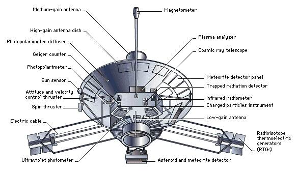
Even as the United States and the USSR raced to explore the Moon, both countries were also readying missions to travel farther afield. Earth’s closest neighbors, Venus and Mars, became the first planets to be visited by spacecraft in the mid-1960s. By the close of the 20th century, spacecraft had visited every planet in the solar system, except for the outermost planet—tiny, frigid Pluto.
Only one spacecraft has visited the solar system’s innermost planet, Mercury. The U.S. probe Mariner 10 flew past Mercury on March 29, 1974, and sent back close-up pictures of a heavily cratered world resembling Earth’s Moon. Mariner 10’s flyby also helped scientists refine measurements of the planet’s size and density. It revealed that Mercury has a weak magnetic field but lacks an atmosphere. After the first flyby, Mariner 10’s orbit brought it past Mercury for two more encounters, in September 1974 and March 1975, which added to the craft’s harvest of data. In its three flybys, Mariner 10 photographed 57 percent of the planet’s surface.
The U.S. Mariner 2 probe became the first successful interplanetary spacecraft when it flew past Venus on December 14, 1962. Mariner 2 carried no cameras, but it did send back valuable data regarding conditions beneath Venus’s thick, cloudy atmosphere. From measurements by Mariner 2’s sensors, scientists estimated the surface temperature to be 400°C (800°F—hot enough to melt lead), dispelling any notions that Venus might be very similar to Earth. In 1973 NASA launched Mariner 10 toward a double encounter with Venus and Mercury. As it flew past Venus on February 5, 1974, Mariner 10’s cameras took the first close-up images of Venus’s clouds, including views in ultraviolet light that recorded distinct patterns in the circulation of Venus’s atmosphere. The USSR explored Venus with their Venera series of probes. Venera 7 made the first successful planetary landing on December 15, 1970, and radioed 23 minutes of data from the Venusian surface, indicating a temperature of nearly 480°C (900°F) and an atmospheric pressure 90 times that on Earth. More Venera successes followed, and on October 22, 1975, Venera 9 landed and sent back black and white images of a rock-strewn plain—the first pictures of a planetary surface beyond Earth. Venera 10 sent back its own surface pictures three days later. Beginning in 1978, a series of spacecraft examined Venus from orbit around the planet. These probes were equipped with radar that pierced the dense, cloudy atmosphere that hides Venus’s surface, giving scientists a comprehensive, detailed look at the terrain beneath. The first of this series, the U.S. Pioneer Venus Orbiter (see Pioneer (spacecraft)), arrived in December 1978 and operated for almost 14 years. The spacecraft’s radar data were compiled into images that showed 93 percent of the planet’s large-scale topographic features. The Soviet Venera 15 and 16 orbiters reached Venus in October 1983, each equipped with radar systems that produced high-resolution images. In eight months of mapping operations, two spacecraft mapped much of Venus’s northern hemisphere, sending back images of mountains, plains, craters, and what appeared to be volcanoes. After being released from the space shuttle Atlantis, NASA’s radar-equipped Magellan orbiter traveled through space and reached Venus in August 1990. During the next four years Magellan mapped Venus at very high resolution, providing detailed images of volcanoes and lava flows, craters, fractures, mountains, and other features. Magellan showed scientists that the surface of Venus is extremely well preserved and relatively young. It also revealed a history of planetwide volcanic activity that may be continuing today.
On July 14, 1965, the U.S. Mariner 4 flew past Mars and took pictures of a small portion of its surface, giving scientists their first close-up look at the red planet. To the disappointment of some who expected a more Earthlike world, Mariner’s pictures showed cratered terrain resembling the Moon’s surface. In August 1969 Mariner 6 and 7 sent back more detailed views of craters and the planet’s icy polar caps. On the whole, these pictures seemed to confirm the impression of a moonlike Mars. NASA’s Mariner 9 went into orbit around Mars in November 1971, providing scientists with the first close-up views of the entire planet. Mariner 9’s pictures revealed giant volcanoes up to five times as high as Mount Everest, a system of canyons that would stretch the length of the continental United States, and—most intriguing of all—winding channels that resemble dry river valleys of Earth. Scientists realized that Mars’s evolution had been more complex and fascinating than they had suspected and that the planet was moonlike in some ways, but surprisingly Earthlike in others. The USSR’s Mars probes were stymied by technical malfunctions. In November 1971 the Mars 2 spacecraft (see Mars (space program)) went into orbit around the planet and released a landing capsule that crashed without returning any data. Mars 2 became the first artificial object to reach the Martian surface. In December 1971 a lander released by the Mars 3 orbiter reached the surface successfully. However, it sent back only 20 seconds of video signals that included no data. In 1973 two more landing missions also failed. In 1988 the USSR made two unsuccessful attempts to explore the Martian moon Phobos. Contact with the spacecraft Phobos 1 (see Phobos (space program)) was lost due to an error by mission controllers when the spacecraft was on its way to Mars. Phobos 2 reached Martian orbit in January 1989 and sent back images of the planet, but failed before its planned rendezvous with Phobos. The U.S. Viking probes made the first successful Mars landings in 1976. Two Viking spacecraft, each consisting of an orbiter and lander, left Earth in August and September 1975. Viking 1 went into orbit around Mars in June 1976, and after a lengthy search for a relatively smooth landing site, the Viking 1 lander touched down safely on Mars’s Chryse Planitia (Plain of Gold) on July 20, 1976. The Viking 2 lander reached Mars’s Utopia Planitia (Utopia Plain) on September 3, 1976. Each lander sent back close-up pictures of a dusty surface littered with rocks, under a surprisingly bright sky (due to sunlight reflecting off of airborne dust). The landers also recorded changes in atmospheric conditions at the surface. They searched, without success, for conclusive evidence of microbial life. The landers continued to send back data for several years, while the orbiters took thousands of high-resolution photographs of the planet. On July 4, 1996, 20 years after Viking 1 arrived, NASA’s Mars Pathfinder spacecraft landed in Mars's Ares Vallis (Mars Valley). Pathfinder used a new landing system featuring pressurized airbags to cushion its impact. The next day, Pathfinder released a 10-kg (22-lb) rover called Sojourner, which became the first wheeled vehicle to operate on another planetary surface. While Pathfinder sent back images, atmospheric measurements, and other data, Sojourner examined rocks and soil with a camera and an Alpha Proton X-ray Spectrometer, which provided data on chemical compositions by measuring how radiation bounced back from rocks and dust. The mission ended when the spacecraft ceased responding to commands from Earth in October 1997. NASA’s Mars Global Surveyor went into orbit around Mars in September 1997. Designed as a replacement for NASA’s Mars Observer probe, which failed before reaching Mars in 1993, Mars Global Surveyor is equipped with a high-resolution camera and instruments to study the planet’s atmosphere, topography and gravity, surface composition, and magnetic field. Global Surveyor reached orbit around Mars in the fall of 1997, but a problem with an unstable solar panel delayed the start of its mission—mapping the entire planet—for about a year. (In the meantime, Mars Global Surveyor began relaying high-resolution images of select areas in early 1998.) Its mapping operation, slated to last for one Martian year (about two Earth years), began in March 1999. Unlike previous Mars probes, Mars Global Surveyor adjusted its orbit using a technique called aerobraking, which relies on friction with the planet’s upper atmosphere—rather than rocket engines—to slow the spacecraft to bring it into a proper mapping orbit. Mars Pathfinder and Mars Global Surveyor were part of a series of spacecraft that NASA plans to send to Mars about every 18 months. The next two spacecraft in the series, Mars Climate Orbiter and Mars Polar Lander, began their journeys to Mars in December 1998 and January 1999, respectively. Both probes reached Mars in late 1999, but Mars Climate Orbiter crashed into the planet due to a navigational error, and software defects led to the crash landing of Mars Polar Lander. Japan launched the spacecraft Nozomi (Japanese for “hope”), destined for Mars, on July 4, 1998. Nozomi contains equipment developed by scientists from around the world, including Canadian space scientists. This is the first time Canada has participated in a mission to another planet. Nozomi is scheduled to reach Mars in 2003.
Date: 2015-04-20; view: 1036
|