CATEGORIES:
BiologyChemistryConstructionCultureEcologyEconomyElectronicsFinanceGeographyHistoryInformaticsLawMathematicsMechanicsMedicineOtherPedagogyPhilosophyPhysicsPolicyPsychologySociologySportTourism
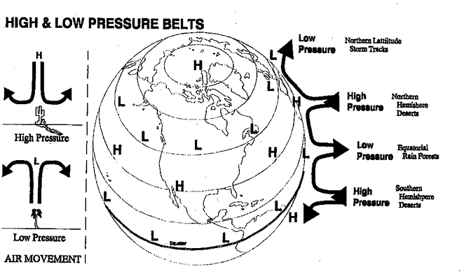
Glacial Till and MorainesThe scoured material carried by the glaciers were deposited in a variety of ways. This material is known as "glacial till." The largest depositional features are moraines which define the edges of a glacier. Long Island (NY) and Nantucket and Martha's Vineyard islands (Mass.) are terminal or end moraines that marked the end of massive glaciers. They are both composed of material carried by glaciers from the interior of the continent. Estuary Bays Because large amounts of the earth's surface water was stored in ice during the glacial advances, sea levels were about 450 feet below their current levels. Much of the North American continental shelf was exposed and a land bridge existed to Asia. Because rivers seek to erode until they reach sea level, the lower sea levels allowed rivers to cut deeper valleys, especially in coastal areas. When sea levels rose, these valleys were filled in, creating Chesapeake Bay (Susquehanna River), Delaware Bay (Delaware River), and New York Harbor (Hudson River). Bays that are created by the filling in of river valleys are called "estuaries." Factors in Weather and Climate Weather refers to the day-to-day changes in the atmosphere of a place. Climate, on the other hand, refers to the annual pattern of atmospheric conditions in a place. Climate classifications are primarily based on (1) the seasonal variations in temperature and (2) the annual rainfall amount and seasonality. The major factors which influence climate are (1) latitude, (2) continentality, (3) air masses, and (4) surface physiography. Latitude Because the earth moves around the sun on a tilted axis, the northern hemisphere is closest to the sun in June and farthest from the sun in December. These extremes become most pronounced as one gets closer to the poles. North of the Arctic Circle, Alaska's summer days have 24 hours of sun, while winter days have 24 hours of cold darkness. At the other extreme, the length of Florida's days stays about the same all year round, and average winter temperatures are only 10 degrees F less than average summer temperatures. Higher latitudes (closer to the poles), therefore, have greater annual temperature extremes and especially cold winters. Continentality and Maritime Climates Land (rocks and dirt) heats and cools faster than does water. Climatically, this means that the large continents of the world are warmer than the oceans in their summer months and colder than the oceans in their winter months. This further contributes to the intense winter cold experienced by the interior of the North American continent. Conversely, summer temperatures are as much as 50 degrees F hotter in the interior of the continent than in coastal areas. Along the edges of the continent, the moderating influence of the oceans keeps summer temperatures down and winter temperatures relatively high. The onshore ocean winds hitting San Francisco, for example, give it almost the same temperature all year round. The maritime climate of San Francisco is the opposite of the continentality of the interior US. High and Low Pressure Air Masses Large movements of air over the surface of the earth generally have either rising or falling patterns. Air that is rising from the earth's surface forms low pressure air masses. When the rising air falls, it forms a high pressure air mass (because the air is pushing down on the earth's surface). Rings of predominantly high and low pressure encircle the earth. Low pressure on the equator brings year-round rainfall, creating tropical rain forests. Descending dry air creates high pressure north and south of the equator. These are where the large deserts of the world (including the Mojave and Sonoran Deserts of the US) are located. Humid low pressure systems ring the globe north of here, creating cool weather rain forests on the coasts of Washington and British Columbia. Finally, a dry high pressure system is situated over the North and South Poles, turning the north coast of Alaska into a frozen desert. High and Low Air Pressure Belts (Diagram)
Date: 2015-02-16; view: 1821
|